Runcton Holme / Rungton Holme / Holme-next-Runcton
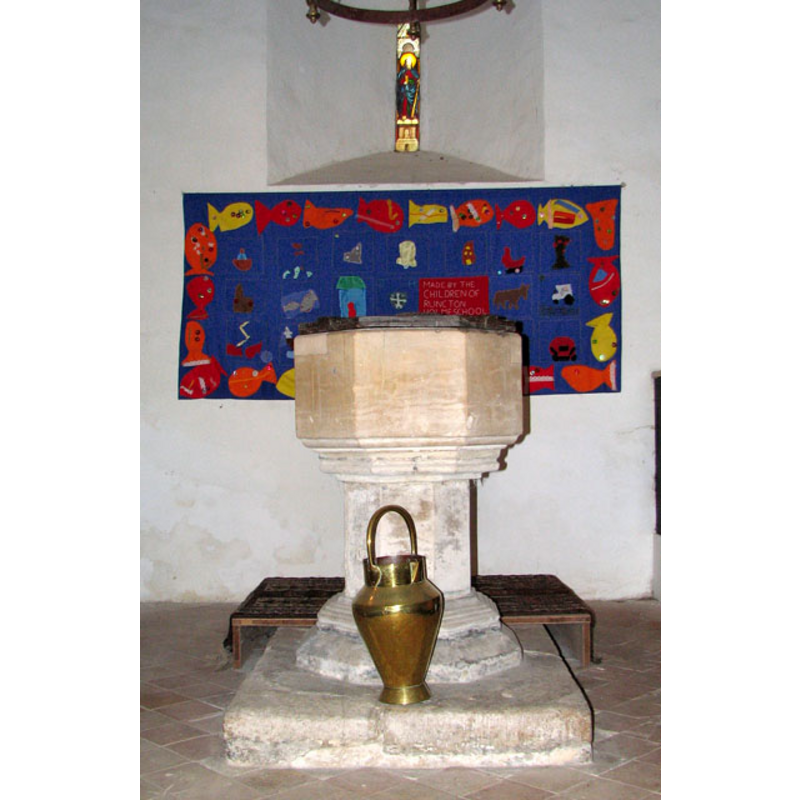
Image copyright © Evelyn Simak, 2010
CC-BY-SA-3.0
Results: 10 records
view of font
Scene Description: [cf. FontNotes]
Copyright Statement: Image copyright © Evelyn Simak, 2010
Image Source: digital photograph taken 6 May 2010 by Evelyn Simak [www.geograph.org.uk/photo/1847357] [accessed 22 August 2013]
Copyright Instructions: CC-BY-SA-3.0
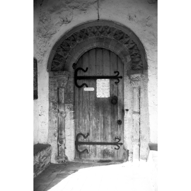
view of church exterior - south portal
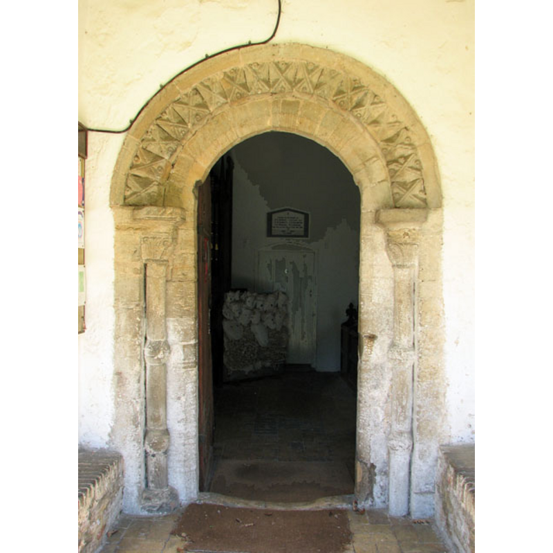
Copyright Statement: Image copyright © Evelyn Simak, 2010
Image Source: digital photograph taken 6 May 2010 by Evelyn Simak [www.geograph.org.uk/photo/1847311] [accessed 22 August 2013]
Copyright Instructions: CC-BY-SA-3.0
view of church exterior - south view
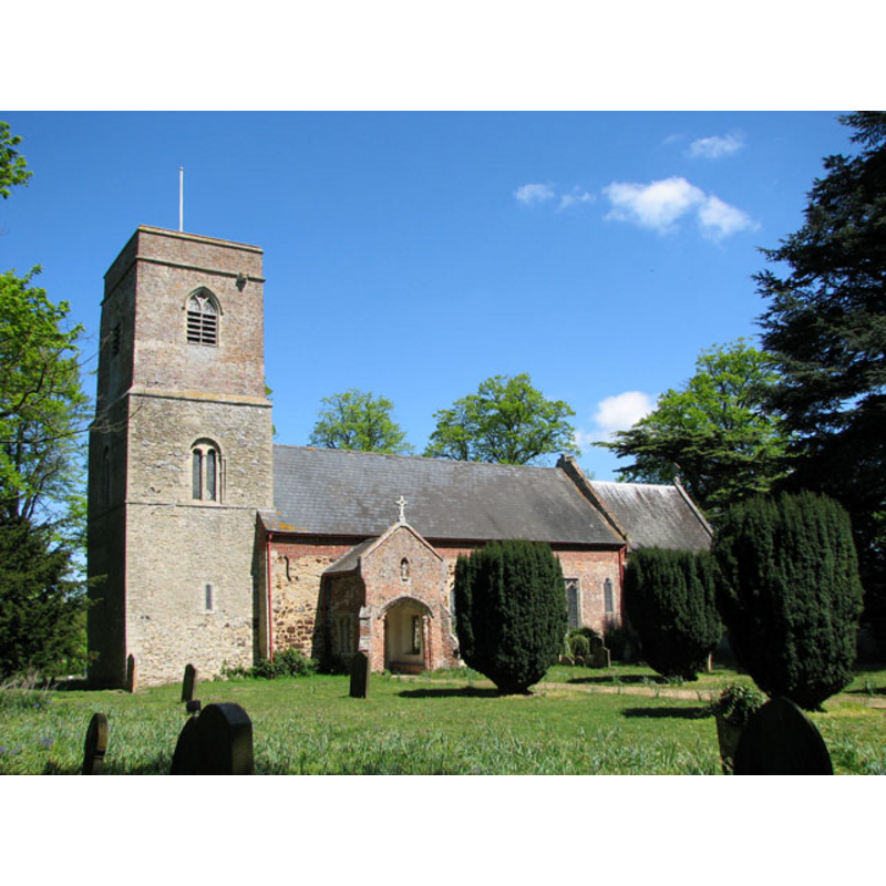
Copyright Statement: Image copyright © Evelyn Simak, 2010
Image Source: digital photograph taken 6 May 2010 by Evelyn Simak [www.geograph.org.uk/photo/1847285] [accessed 22 August 2013]
Copyright Instructions: CC-BY-SA-3.0
view of church exterior - south portal - detail
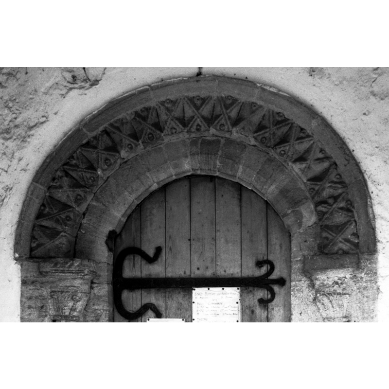
Copyright Statement: Image copyright © George Plunkett, 2013
Image Source: detail of a B&W photograph taken 11 September 1975 by George Plunkett [www.georgeplunkett.co.uk/Norfolk/R/Runcton Holme St James' Norman S door [5473] 1975-09-11.jpg] [accessed 22 August 2013]
Copyright Instructions: Standing permission by Jonathan Plunkett
view of church exterior - south portal
Copyright Statement: Image copyright © George Plunkett, 2013
Image Source: B&W photograph taken 11 September 1975 by George Plunkett [www.georgeplunkett.co.uk/Norfolk/R/Runcton Holme St James' Norman S door [5473] 1975-09-11.jpg] [accessed 22 August 2013]
Copyright Instructions: Standing permission by Jonathan Plunkett
view of church exterior - southwest end
![in 1975 EXT SW END B&W photograph taken 11 September 1975 by George Plunkett [www.georgeplunkett.co.uk/Norfolk/R/Runcton Holme St James' church tower [5474] 1975-09-11.jpg] [accessed 22 August 2013]
S DOOR B&W photograph taken 11 September 1975 by George Plunkett [www.georgeplunkett.co.uk/Norfolk/R/Runcton Holme St James' Norman S door [5473] 1975-09-11.jpg] [accessed 22 August 2013]
EXT S digital photograph taken 6 May 2010 by Evelyn Simak [www.geograph.org.uk/photo/1847285] [accessed 22 August 2013]
EXT S PORTAL digital photograph taken 6 May 2010 by Evelyn Simak [www.geograph.org.uk/photo/1847311] [accessed 22 August 2013]
INT E digital photograph taken 6 May 2010 by Evelyn Simak [www.geograph.org.uk/photo/1847318] [accessed 22 August 2013]
INT W digital photograph taken 6 May 2010 by Evelyn Simak [www.geograph.org.uk/photo/1847346] [accessed 22 August 2013]
FONT digital photograph taken 6 May 2010 by Evelyn Simak [www.geograph.org.uk/photo/1847357] [accessed 22 August 2013]](/static-50478a99ec6f36a15d6234548c59f63da52304e5/compressed/1130825064_compressed.png)
Scene Description: in 1975 EXT SW END B&W photograph taken 11 September 1975 by George Plunkett [www.georgeplunkett.co.uk/Norfolk/R/Runcton Holme St James' church tower [5474] 1975-09-11.jpg] [accessed 22 August 2013]
S DOOR B&W photograph taken 11 September 1975 by George Plunkett [www.georgeplunkett.co.uk/Norfolk/R/Runcton Holme St James' Norman S door [5473] 1975-09-11.jpg] [accessed 22 August 2013]
EXT S digital photograph taken 6 May 2010 by Evelyn Simak [www.geograph.org.uk/photo/1847285] [accessed 22 August 2013]
EXT S PORTAL digital photograph taken 6 May 2010 by Evelyn Simak [www.geograph.org.uk/photo/1847311] [accessed 22 August 2013]
INT E digital photograph taken 6 May 2010 by Evelyn Simak [www.geograph.org.uk/photo/1847318] [accessed 22 August 2013]
INT W digital photograph taken 6 May 2010 by Evelyn Simak [www.geograph.org.uk/photo/1847346] [accessed 22 August 2013]
FONT digital photograph taken 6 May 2010 by Evelyn Simak [www.geograph.org.uk/photo/1847357] [accessed 22 August 2013]
Copyright Statement: Image copyright © George Plunkett, 2013
Image Source: B&W photograph taken 11 September 1975 by George Plunkett [www.georgeplunkett.co.uk/Norfolk/R/Runcton Holme St James' church tower [5474] 1975-09-11.jpg] [accessed 22 August 2013]
Copyright Instructions: Standing permission by Jonathan Plunkett
view of church interior - nave - looking west
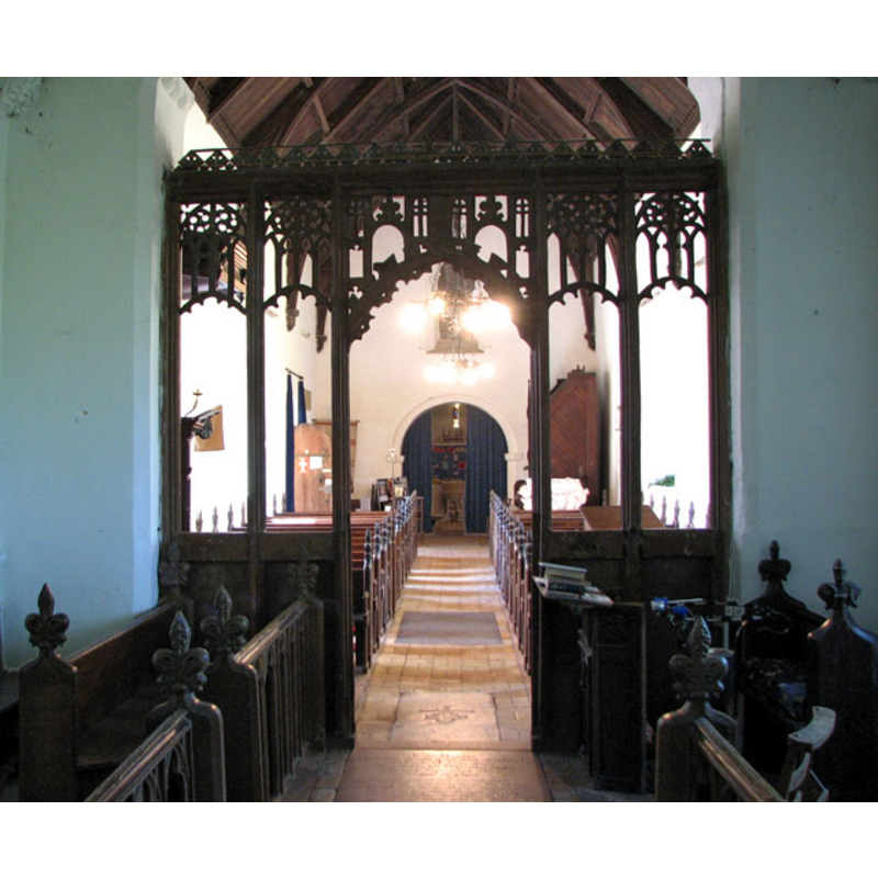
Copyright Statement: Image copyright © Evelyn Simak, 2010
Image Source: digital photograph taken 6 May 2010 by Evelyn Simak [www.geograph.org.uk/photo/1847346] [accessed 22 August 2013]
Copyright Instructions: CC-BY-SA-3.0
view of church interior - nave - looking east
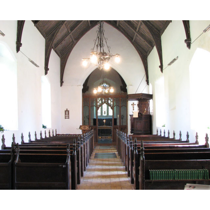
Copyright Statement: Image copyright © Evelyn Simak, 2010
Image Source: digital photograph taken 6 May 2010 by Evelyn Simak [www.geograph.org.uk/photo/1847318] [accessed 22 August 2013]
Copyright Instructions: CC-BY-SA-3.0
view of font and cover

Scene Description: date unknown
Copyright Statement: Image copyright © Our Past History, 2009
Image Source: detail of an old postcard in Our Past History [http://ourpasthistory.com/Gallery/album419/Untitled_Scanned_21_004?full=1] [accessed 20 August 2009]
Copyright Instructions: PERMISSION NOT AVAILABLE -- IMAGE NOT FOR PUBLIC USE
view of church interior - nave - looking west
Scene Description: date unknown
Copyright Statement: Image copyright © Our Past History, 2009
Image Source: old postcard in Our Past History [http://ourpasthistory.com/Gallery/album419/Untitled_Scanned_21_004?full=1] [accessed 20 August 2009]
Copyright Instructions: PERMISSION NOT AVAILABLE -- IMAGE NOT FOR PUBLIC USE
INFORMATION
Font ID: 15164RUN
Object Type: Baptismal Font1
Font Century and Period/Style: 15th century, Perpendicular
Church / Chapel Name: Church of St. James
Font Location in Church: Inside the church, at the W end of the nave
Church Patron Saint(s): St. James
Church Notes: church originally early-12thC
Church Address: Church Lane, Runcton Holme, Norfolk PE33 0AP
Site Location: Norfolk, East Anglia, England, United Kingdom
Directions to Site: Located 6 km N of Downham
Ecclesiastic Region: Diocese of Ely
Historical Region: Hundred and helf of Clackclose
Additional Comments: disappeared font? (the one from the early-12thC church here?) -- restored font (the present 15thC one)
Font Notes:
Click to view
Blomefield (1805-1810) writes; "The chapel of Holme is dedicated to St. James, and is an old building, having a nave and a chancel built of rag stone, and covered with reed; at the east end of the nave, which is about 52 feet in length, lies a marble grave-stone, [...] at the west end is a four-square tower, the lower part of rag stone, and quoins of free stone, the upper part (where it has decayed) is of brick and embattled, in which hang three bells. The chancel is separated from the nave by an old screen, and is about 24 feet in length, and 15 in breadth [...] This, as has been observed, is a chapel in the parish of Rungton, but had anciently the privilege of burial and baptism." The Our Past History site [http://ourpasthistory.com/Gallery/album419/Untitled_Scanned_21_004] [accessed 20 August 2009] has an old undated postcard showing a font at the west end of the nave, beneath the tower; the font consists of a plain octagonal basin, raised on a pedestal base and plinth; the only decoration on it appear to be the graded mouldings on the underbowl and lower base. [NB: the font appears to be from the 15th century, probably from the major re-building at the time].
COORDINATES
UTM: 31U 323469 5837567
Latitude & Longitude (Decimal): 52.659282, 0.389806
Latitude & Longitude (DMS): 52° 39′ 33.41″ N, 0° 23′ 23.3″ E
MEDIUM AND MEASUREMENTS
Material: stone
Font Shape: oval
Basin Interior Shape: round
Basin Exterior Shape: octagonal
LID INFORMATION
Date: 19th century?
Material: wood, oak?
Apparatus: no
Notes: octagonal, plain and flat
REFERENCES
- Blomefield, Francis, An essay towards a topographical history of Norfolk, 1805-1810, vol. 7: 403-408 / [www.british-history.ac.uk/report.aspx?compid=78371] [accessed 22 August 2013]