Mintlyn / Meltinga / Mintling / Mintlynn / Mintlinghe
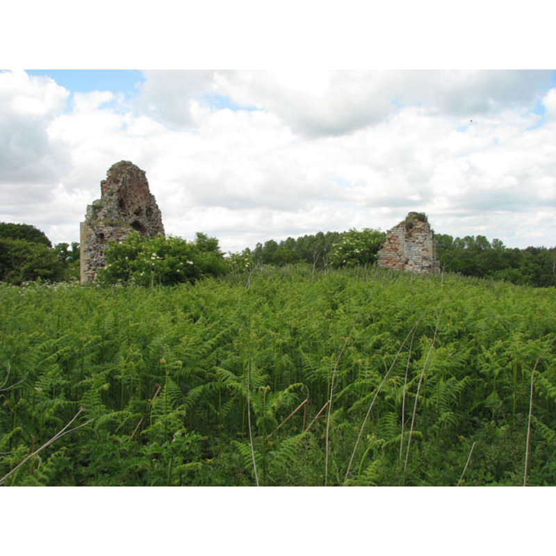
Image copyright © Evelyn Simak, 2009
CC-BY-SA-3.0
Results: 4 records
view of church exterior - southeast view
Copyright Statement: Image copyright © Evelyn Simak, 2009
Image Source: digital photograph taken 26 May 2009 by Evelyn Simak [www.geograph.org.uk/photo/1322477][accessed 14 November 2013]
Copyright Instructions: CC-BY-SA-3.0
view of church exterior - southwest end

Copyright Statement: Image copyright © Evelyn Simak, 2009
Image Source: digital photograph taken 26 May 2009 by Evelyn Simak [www.geograph.org.uk/photo/1322477][accessed 14 November 2013]
Copyright Instructions: CC-BY-SA-3.0
view of church exterior - detail
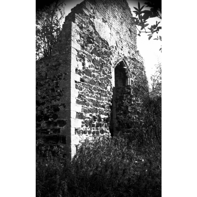
Scene Description: Photo caption: "Fragmentary ruins. The Norman doorway mentioned by Claude Messent being here in 1931 has disappeared"
Copyright Statement: Image copyright © George Plunkett, 2013
Image Source: EXT B&W photograph taken 21 August 1976 by George Plunkett [www.georgeplunkett.co.uk/Norfolk/M/Mintlyn St Michael's church ruin gable [5671] 1976-08-21.jpg] [accessed 14 November 2013]
Copyright Instructions: Standing permission by Jonathan Plunkett
view of church exterior - south portal
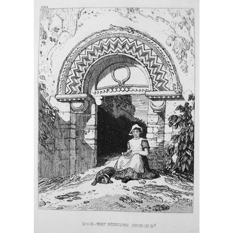
Scene Description: the disappeared Norman doorway as recorded ca. 1817
Copyright Statement: Image copyright © [in the public domain]
Image Source: etching ca. 1817 by John Sell Cotman (1782-1842) [probably 1836 issue], in trentprints [www.ebay.co.uk/usr/trentprints][accessed 14 November 2013]
Copyright Instructions: PD
INFORMATION
Font ID: 15129MIN
Object Type: Baptismal Font1
Font Century and Period/Style: 12th century, Norman
Church / Chapel Name: Parish Church of St. Michael [in ruins]
Font Location in Church: [cf. FontNotes]
Church Wikidata: https://www.wikidata.org/wiki/Q17555589
Church Patron Saint(s): St. Michael
Church Notes: White's Directory of 1845 reported that the church of St. Michael "has long been in ruins".
Church Address: [Ruins of Church of St Michael at TF 657 192] Bawsey, Norfolk PE32 1HA
Site Location: Norfolk, East Anglia, England, United Kingdom
Directions to Site: Located just S of Bawsey Church, 4 km ENE of King's Lynn [the remains of the old church are located just N of the dismantled railway line, S of Chaple Plantation, OS TF 661 186]
Ecclesiastic Region: [Diocese of Norwich]
Historical Region: Hundred and half of Freebridge
Additional Comments: base lost?
Font Notes:
Click to view
The Domesday survey entry for "Meltinga" [http://domesdaymap.co.uk/place/TF6519/mintlyn/][accessed 14 November 2013] mentions neither church nor cleric in it. Blomefield (1895-1810) writes: "The Church is dedicated to St. Michael [...] Bishop Herbert gave this church to the monks of Norwich, residing at Lynn, and it was appropriated by John de Grey Bishop of Norwich, about 1205, saving to himself and successours all episcopal and parochial rights." This "Bishop Herbert" must be Herbert de Losinga (1054?-1119), a Norman, bishop of Thetford ca, 1090, and first bishop of Norwich [source: Dictionary of National Biography (1885-1900, v. 34 [http://en.wikisource.org/wiki/Losinga,_Herbert_de_(DNB029), therefore it can be safely assumed that Mintlyn St. Michael's was a functioning parish church by 1119. White's Directory of 1845 notes: "Its small [church], dedicated to St. Michael, has long been in ruins, but the gables and side walls are still standing. Mintlynn is now a sort of extra-parochial liberty, having neither church nor pastor." White's Directory for 1883 repeats the text of the 1845 edition [www.origins.org.uk/genuki/NFK/places/m/mintlyn/white1883.shtml] [accessed 14 November 2013] and adds "The south doorway is of fine proportions, and rich in the characteristic features of the best period of the Norman style." [NB: we have not been able to establish the present whereabouts of the Norman font here]. Pevsner & Wilson (1999) note: "The font is a plain circular C12 bowl in the garden of Whitehouse Farmhouse", about 1 km to the southeast [OS map: Tf 661 186]. Evelyn Simak [www.geograph.org.uk/photo/1322478][accessed 14 November 2013] notes on the ruins of St. Michael: "The fenced-off ruins of St Michael's church are situated on an elevation, surrounded by fields on all sides. Only sections of the nave walls survive, revealing that the building materials used were carstone, stone, brick and fragments of metal working debris. Remains of a C11/C12 arch are now in King's Lynn Museum and the font is in a nearby garden. The church once stood within a now deserted village the exact extent of which is not known. Several villages are documented to have existed in this area until at least up to the 16th century. It was during that period that the then landowner - Thomas Thursby and his son - evicted their tenants by pulling down their dwellings and depriving them of their commons in order to turn the area into farmland that was converted to sheep pasture in numerous villages (four of which now lost), reminiscent of the Clearances in Scotland. Two churches have survived, albeit as ruins: St James' is situated north of the B1145 and St Michael's to the south of the road. This land is private and was accessed with kind permission of the owner." The English Heritage listing of 20-Jun-1988, list entry no.: 1077666 with National Grid Reference: TF6612218630 [http://list.english-heritage.org.uk/resultsingle.aspx?uid=1077666][accessed 14 November 2013] reads: "Font against south facade of Whitehouse Farmhouse TF 6613 1862 II Font from remains of Church of St. Michael Mintlyn q.v. 5/3. C12. Plain round stemless limestone tub."
COORDINATES
Latitude & Longitude (Decimal): 52.7450, 0.4533
Latitude & Longitude (DMS): 52° 44' 44" N, 0° 27' 12" E
MEDIUM AND MEASUREMENTS
Material: stone
Font Shape: tub-shaped
Basin Interior Shape: round
Basin Exterior Shape: round
REFERENCES
- Blomefield, Francis, An essay towards a topographical history of Norfolk, 1805-1810, vol. 425-439 / [www.british-history.ac.uk/report.aspx?compid=78487] [accessed 14 November 2013]
- Pevsner, Nikolaus, Norfolk 2: North-West and South (2nd ed.), London: Penguin, 1999, p. 544
- White, William, History, gazetteer, and directory of Norfolk and the city and County of the city of Norwich [...], Sheffield: Robert Leader, 1845, [transcribed in www.origins.org.uk/genuki/NFK/places/m/mintlyn/white1845.shtml [accessed 14 November 2013]]