Gressenhall / Garsighnehael / Gressenhale / Gressenhalle / Gressinghale
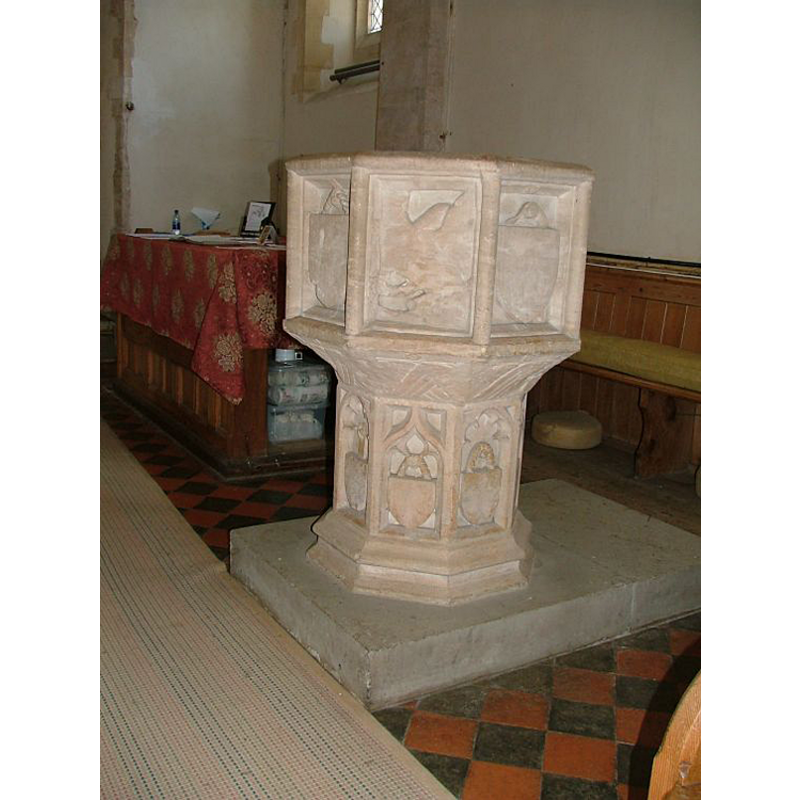
Image copyright © Simon Knott, 2006
Standing permission
Results: 10 records
view of font
Copyright Statement: Image copyright © Simon Knott, 2006
Image Source: digital photograph taken 25 July 2006 by Simon Knott [www.norfolkchurches.co.uk/gressenhall/gressenhall.htm] [accessed 4 August 2009]
Copyright Instructions: Standing permission
symbol - unidentified - 4
Scene Description: [cf. Font notes]
Copyright Statement: Image copyright © Simon Knott, 2006
Image Source: digital photograph taken 25 July 2006 by Simon Knott [www.norfolkchurches.co.uk/gressenhall/gressenhall.htm] [accessed 4 August 2009]
Copyright Instructions: Standing permission
symbol - shield - hanging shield - blank - 4
Copyright Statement: Image copyright © Simon Knott, 2006
Image Source: digital photograph taken 25 July 2006 by Simon Knott [www.norfolkchurches.co.uk/gressenhall/gressenhall.htm] [accessed 4 August 2009]
Copyright Instructions: Standing permission
angel - head - 8
Scene Description: all destroyed [cf. Font notes]
Copyright Statement: Image copyright © Simon Knott, 2006
Image Source: digital photograph taken 25 July 2006 by Simon Knott [www.norfolkchurches.co.uk/gressenhall/gressenhall.htm] [accessed 4 August 2009]
Copyright Instructions: Standing permission
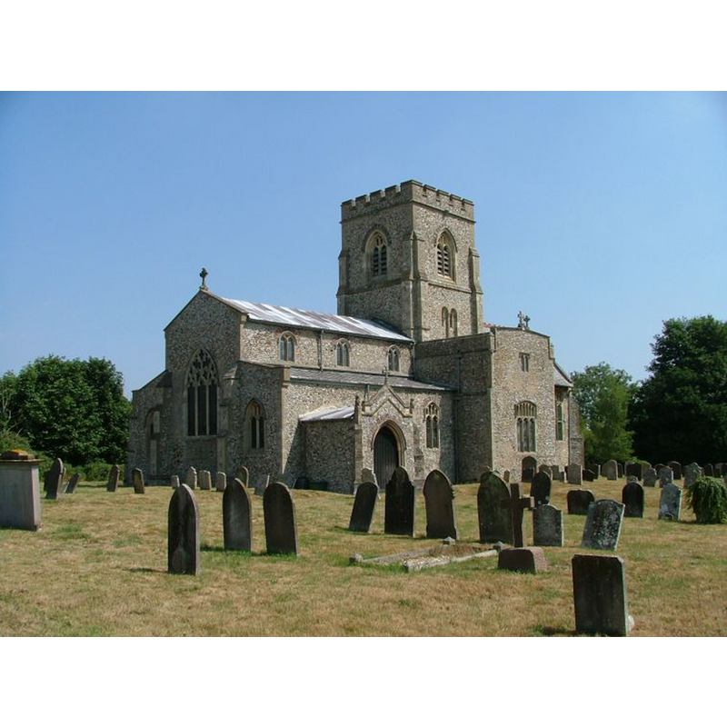
view of church exterior - southwest view
Copyright Statement: Image copyright © Simon Knott, 2006
Image Source: digital photograph taken 25 July 2006 by Simon Knott [www.norfolkchurches.co.uk/gressenhall/gressenhall.htm] [accessed 10 February 2014]
Copyright Instructions: Standing permission
view of church exterior - southeast view

Scene Description: Photo caption: "First two stages of central tower are Norman"
Copyright Statement: Image copyright © George Plunkett, 2014
Image Source: B&W photograph taken 31 May 1976 by George Plunkett [www.georgeplunkett.co.uk/Norfolk/G/Gressenhall St Mary's church from SE [5544] 1976-05-31.jpg] [accessed 10 February 2014]
Copyright Instructions: Standing permission by Jonathan Plunkett
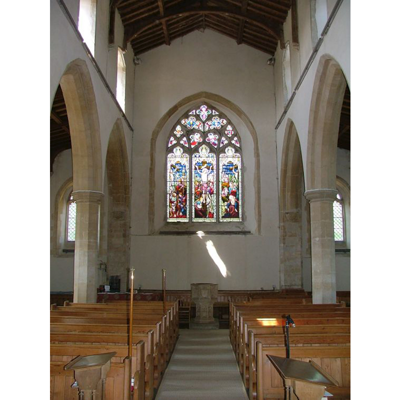
view of church interior - nave - looking west
Copyright Statement: Image copyright © Simon Knott, 2006
Image Source: digital photograph taken 25 July 2006 by Simon Knott [www.norfolkchurches.co.uk/gressenhall/gressenhall.htm] [accessed 10 February 2014]
Copyright Instructions: Standing permission
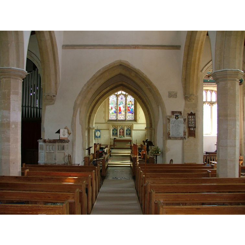
view of church interior - nave - looking east
Copyright Statement: Image copyright © Simon Knott, 2006
Image Source: digital photograph taken 25 July 2006 by Simon Knott [www.norfolkchurches.co.uk/gressenhall/gressenhall.htm] [accessed 10 February 2014]
Copyright Instructions: Standing permission
symbol - shield - hanging shield - blank - in a traceried panel - 8
Copyright Statement: Image copyright © Simon Knott, 2006
Image Source: digital photograph taken 25 July 2006 by Simon Knott [www.norfolkchurches.co.uk/gressenhall/gressenhall.htm] [accessed 4 August 2009]
Copyright Instructions: Standing permission
design element - motifs - moulding
Copyright Statement: Image copyright © Simon Knott, 2006
Image Source: digital photograph taken 25 July 2006 by Simon Knott [www.norfolkchurches.co.uk/gressenhall/gressenhall.htm] [accessed 4 August 2009]
Copyright Instructions: Standing permission
INFORMATION
Font ID: 15079GRE
Object Type: Baptismal Font1
Font Century and Period/Style: 15th century, Perpendicular
Workshop/Group/Artisan: Evangelists' font? / heraldic font
Church / Chapel Name: Parish Church of the Assumption of the Blessed Virgin [aka St. Mary's]
Font Location in Church: Inside the church, at the W end of the nave
Church Patron Saint(s): The Assumption of St. Mary
Church Address: Church Lane, Gressenhall, Norfolk, NR19 2QH
Site Location: Norfolk, East Anglia, England, United Kingdom
Directions to Site: Located 5 km NW of East Dereham
Ecclesiastic Region: Diocese of Norwich
Historical Region: Hundred of Launditch
Additional Comments: altered font / damaged font / vandalised font (the present one) -- disappeared font? (the one from the mid-14thC church (or Norman?) here)
Font Notes:
Click to view
There is an entry for Gressenhall in the Domesady survey [http://domesdaymap.co.uk/place/TF9515/gressenhall/] [accessed 10 February 2014], but it mentions neither church nor cleric in it. Blomefield (1805-1810) writes: "The Church of Gressenhale is a large pile, built in a cathedral manner, with a north and south transept, and a tower in the middle, as you enter the chancel, which tower decaying, license was granted January 28, 1698, to take down the spire on the top of it. This tower had been repaired in 1491 [...] The church is dedicated to the assumption of the Blessed Virgin [...] In 1344, John de Rothing occurs rector." Blomefield (ibid.) writes also of a chapel here dedicated to St. Nicholas: "founded in a place called Rougholm in Gressinghale, by William de Stutevil, lord of the town, in the reign of Henry III [i.e., 1216-1272] [...] It was a long narrow building, with a north and south transept, and a chancel, which, with the north transept, is in ruins, the rest still standing, and now an house"; it appears it had a chaplain but did not have parochial functions; presumably a parish church would have existed in Gressenhall before the building of this chapel, but the earliets mention of a parish church here is 1344, the date of the first-recorded rector of St. Mary's; the lower stages of the tower are said to be Norman. The present font here is described in Pevsner & Wilson (1999): "Octagonal, Perp[endicular]. Eight shields against the stem; four shields against the bowl; the other four sides defaced. Noted and illustrated in Knott (2006): "The 15th century font has been enthusiastically vandalised; most of the panels feature hanging shields, but on one panel in particular the iconoclasts really went to town. I wonder what it depicted." [NB: it is quite possible that the four vandalised sides had the symbols of the four Evangelists [one of the sides appears to have the outline of a bird; eagle of St. John?]; the underbowl chamfer has had the angel heads chiselled off, and now only the wings can be discerned on the sides; the octagonal stem has the same type of blank hanging shields on the panels, here surmounted by tracery patterns; on a moulded lower base.
Credit and Acknowledgements: We are grateful to Simon Knott, of www.norfolkchurches.co.uk, for the photographs of this church and font; we are also grateful to Jonathan Plunkett for the photograph of this church taken by his father, George Plunkett, in May 1976
COORDINATES
UTM: 31U 357946 5841144
Latitude & Longitude (Decimal): 52.701543, 0.897628
Latitude & Longitude (DMS): 52° 42′ 5.56″ N, 0° 53′ 51.46″ E
MEDIUM AND MEASUREMENTS
Material: stone
Font Shape: octagonal, mounted
Basin Interior Shape: round
Basin Exterior Shape: octagonal
REFERENCES
- Blomefield, Francis, An essay towards a topographical history of Norfolk, 1805-1810, vol. 9: 510-520 / [www.british-history.ac.uk/report.aspx?compid=78608] [accessed 10 February 2014]
- Knott, Simon, The Norfolk Churches Site, Simon Knott, 2004. [standing permission to reproduce images received from Simon (February 2005]. URL: www.norfolkchurches.co.uk.
- Pevsner, Nikolaus, Norfolk 2: North-West and South (2nd ed.), London: Penguin, 1999, p. 370