Great Melton / Meletuna / Melftunana / Melton Magna / Meltuna / Middleton
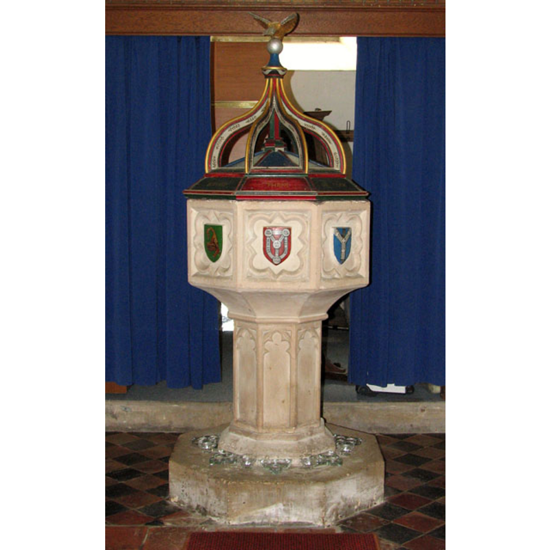
Image copyright © Evelyn Simak, 2010
CC-BY-SA-3.0
Results: 10 records
view of font and cover
Scene Description: [cf. Font notes]
Copyright Statement: Image copyright © Evelyn Simak, 2010
Image Source: digital photograph taken 7 June 2010 by Evelyn Simak [www.geograph.org.uk/photo/1902947] [accessed 20 Marcg 2013]
Copyright Instructions: CC-BY-SA-3.0
symbol - shield - coat of arms - in a panel - cusped panel - 8
![[cf. Font notes]](/static-50478a99ec6f36a15d6234548c59f63da52304e5/compressed/1130329056_compressed.png)
Scene Description: [cf. Font notes]
Copyright Statement: Image copyright © Evelyn Simak, 2010
Image Source: digital photograph taken 7 June 2010 by Evelyn Simak [www.geograph.org.uk/photo/1902953] [accessed 20 Marcg 2013]
Copyright Instructions: CC-BY-SA-3.0
design element - architectural - arch or window - cinquefoiled - 8
Scene Description: [cf. Font notes]
Copyright Statement: Image copyright © Evelyn Simak, 2010
Image Source: digital photograph taken 7 June 2010 by Evelyn Simak [www.geograph.org.uk/photo/1902947] [accessed 20 Marcg 2013]
Copyright Instructions: CC-BY-SA-3.0
view of church exterior - west tower
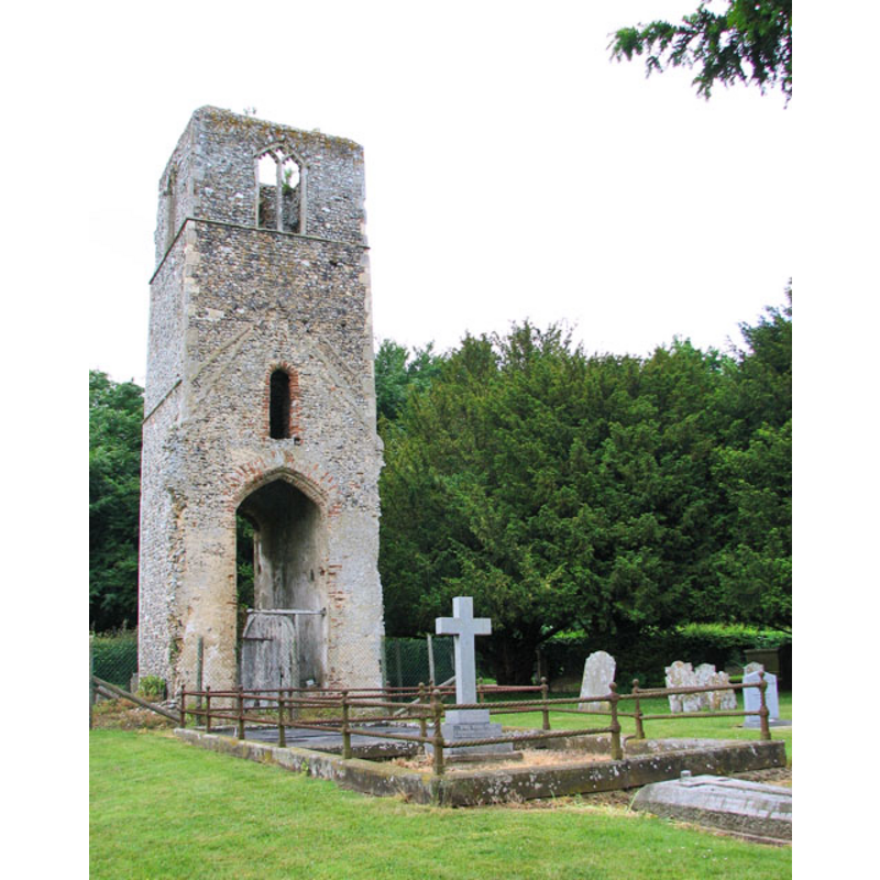
Scene Description: the ruins of St. Mary's church
Copyright Statement: Image copyright © Evelyn Simak, 2010
Image Source: digital photograph taken 7 June 2010 by Evelyn Simak [www.geograph.org.uk/photo/1902885] [accessed 20 March 2013]
Copyright Instructions: CC-BY-SA-3.0
view of church exterior
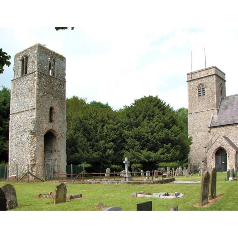
Scene Description: the two chures side by side: St. Mary on the left, All Saints on the right
Copyright Statement: Image copyright © Evelyn Simak, 2010
Image Source: digital photograph taken 7 June 2010 by Evelyn Simak [www.geograph.org.uk/photo/1902891] [accessed 20 March 2013]
Copyright Instructions: CC-BY-SA-3.0
view of church exterior - south view
![the present church of All Saints
EXT SE AllSaints digital photograph taken 7 June 2010 by Evelyn Simak [www.geograph.org.uk/photo/1902893] [accessed 20 Marcg 2013]
EXT BOTH Churches digital photograph taken 7 June 2010 by Evelyn Simak [www.geograph.org.uk/photo/1902891] [accessed 20 March 2013]
EXT MARY RUIN digital photograph taken 7 June 2010 by Evelyn Simak [www.geograph.org.uk/photo/1902885] [accessed 20 March 2013]
INT E AllSaints digital photograph taken 7 June 2010 by Evelyn Simak [www.geograph.org.uk/photo/1902915] [accessed 20 Marcg 2013]
INT W AllSaints digital photograph taken 7 June 2010 by Evelyn Simak [www.geograph.org.uk/photo/1902945] [accessed 20 Marcg 2013]
FONT AllSaints digital photograph taken 7 June 2010 by Evelyn Simak [www.geograph.org.uk/photo/1902947] [accessed 20 Marcg 2013]
FONTCOVER AllSaints digital photograph taken 7 June 2010 by Evelyn Simak [www.geograph.org.uk/photo/1902953] [accessed 20 Marcg 2013]](/static-50478a99ec6f36a15d6234548c59f63da52304e5/compressed/1130329050_compressed.png)
Scene Description: the present church of All Saints
EXT SE AllSaints digital photograph taken 7 June 2010 by Evelyn Simak [www.geograph.org.uk/photo/1902893] [accessed 20 Marcg 2013]
EXT BOTH Churches digital photograph taken 7 June 2010 by Evelyn Simak [www.geograph.org.uk/photo/1902891] [accessed 20 March 2013]
EXT MARY RUIN digital photograph taken 7 June 2010 by Evelyn Simak [www.geograph.org.uk/photo/1902885] [accessed 20 March 2013]
INT E AllSaints digital photograph taken 7 June 2010 by Evelyn Simak [www.geograph.org.uk/photo/1902915] [accessed 20 Marcg 2013]
INT W AllSaints digital photograph taken 7 June 2010 by Evelyn Simak [www.geograph.org.uk/photo/1902945] [accessed 20 Marcg 2013]
FONT AllSaints digital photograph taken 7 June 2010 by Evelyn Simak [www.geograph.org.uk/photo/1902947] [accessed 20 Marcg 2013]
FONTCOVER AllSaints digital photograph taken 7 June 2010 by Evelyn Simak [www.geograph.org.uk/photo/1902953] [accessed 20 Marcg 2013]
Copyright Statement: Image copyright © Evelyn Simak, 2010
Image Source: digital photograph taken 7 June 2010 by Evelyn Simak [www.geograph.org.uk/photo/1902893] [accessed 20 Marcg 2013]
Copyright Instructions: CC-BY-SA-3.0
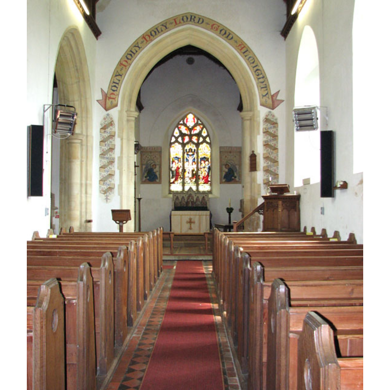
view of church interior - nave - looking west
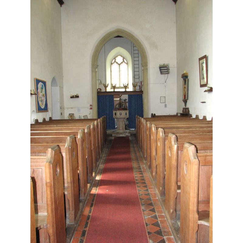
Scene Description: the interior of All Saints' showing the font and cover at the west end, centre aisle
Copyright Statement: Image copyright © Evelyn Simak, 2010
Image Source: digital photograph taken 7 June 2010 by Evelyn Simak [www.geograph.org.uk/photo/1902945] [accessed 20 Marcg 2013]
Copyright Instructions: CC-BY-SA-3.0
view of church interior - nave - looking east
Scene Description: the interior of All Saints'
Copyright Statement: Image copyright © Evelyn Simak, 2010
Image Source: digital photograph taken 7 June 2010 by Evelyn Simak [www.geograph.org.uk/photo/1902915] [accessed 20 Marcg 2013]
Copyright Instructions: CC-BY-SA-3.0
view of font cover
Copyright Statement: Image copyright © Evelyn Simak, 2010
Image Source: digital photograph taken 7 June 2010 by Evelyn Simak [www.geograph.org.uk/photo/1902953] [accessed 20 Marcg 2013]
Copyright Instructions: CC-BY-SA-3.0
view of font and cover

Copyright Statement: Image copyright © Peter Stephens, 2005
Image Source: digital photograph taken by Peter Stephens [www.norfolkchurches.co.uk/greatmelton/greatmelton.htm] [accessed 31 July 2009]
Copyright Instructions: PERMISSION NOT AVAILABLE -- IMAGE NOT FOR PUBLIC USE
INFORMATION
Font ID: 15063MEL
Object Type: Baptismal Font1
Font Century and Period/Style: 15th century / 19th century, Perpendicular? / Victorian?
Workshop/Group/Artisan: heraldic font
Church / Chapel Name: Parish Church of All Saints [cf. ChurchNotes]
Font Location in Church: Inside the church, at the W end of the nave
Church Patron Saint(s): All Saints [cf. Church Notes]
Church Notes: NB: the standing church here ca.1805 was St. Mary's, while All Saint's was in ruins. This same description is appears in Wilson's Gazetteer of 1870-1872 [cf. FontNotes]; the curch in ruins now is St. Mary's. Was the dedication changed at a later date?
Church Address: Market Lane, Great Melton, Norfolk NR9 3BH
Site Location: Norfolk, East Anglia, England, United Kingdom
Directions to Site: Located 10 km WSW of Norwich
Ecclesiastic Region: Diocese of Norwich
Historical Region: Hundred of Humble-Yard
Additional Comments: white-washed font / painted font: the shields on the basin sides -- disappeared fonts? (the fonts from the two 12thC-13thC churches here)
Font Notes:
Click to view
Blomefield (1805-1810) writes: "G[reat Melton], Or Middle-ton, had two churches standing very near one another in the same churchyard; that dedicated to St. Mary the Virgin is now standing, and in use; it belonged to the manor of Hacon's or Hakun's in this town, and when Norwich Domesday was made, Ric. Hakun was patron of it [...] The tower was built in 1440, and hath three bells in it; the church hath only one isle, which is thatched, as is the south porch; the chancel is tiled." Blomefield (ibid.) names "William de Melton" as patron and first recorded rector of Melton St. Mary's, in 1199; the "Hacun" or "Hakun" noted above were the family that bought the manor in 1205, "Ric. Hakun" being owner between 1205 and 1209. The other church noted in Blomefield's entry for Great Melton was All Saints': "This church [...] is ruinated; the steeple is square, the nave is 20 yards long, and the chancel 9, it had a south porch, but no isles", its first recorded rector, "Remigius Skileman", in 1301. Of the three entries in Domesday cited by Blomefield (ibid.) (fol. 167, 206: 'Meltuna'; fol. 306: 'Meletuna') none mentions either church or priest in them. Wilson's Gazetteer of 1870-1872) informs: "The present parish comprises two ancient parishes, M.St. Mary and M. All Saints, consolidated in the time of Queen Anne. [...] The church of St. Mary is later English; and consists of nave and chancel, with S porch and small tower. The church of All Saints is a ruin, and has a fine ivy-clad tower." The entry for this parish in Kelly's Directory of 1883, however, reads: "Great Melton consists of two distinct parishes, St. Mary and All Saints, consolidated in the reign of Queen Anne. All Saints church was suffered to go to decay in accordance with Act of Parliament in 1710, since which the church of St. Mary has been in use, but in consequence of its recent dilapidated condition it has been demolished and All Saints church rebuilt, and a new north transept and vestry added: the present edifice is built of flints with stone dressings and is in the Decorated style (sufficient indications having existed showing that to be the original architecture during probably the middle of the 13th century), except the new south porch, which was known as Perpendicular and of the date 1455: the present church consists of chancel, nave, north transept, south porch and square tower, which alone remained of the original structure, this has been thoroughly restored and contains 3 bells: the chancel contains an Early English window removed from the church of St. Mary". The present font here is illustrated in Knott (2005). Baptismal font with shields-in-barbed-quatrefoil motifs, these somewhat similar to those on the font at Great Ellingham, but brightly painted; the font itself is not like the latter; instead is a typical 15th-century design, the octagonal stem with cinquefoil-headed arches or windows. The font appears too sharp to be 15th-century, and may be a 19th-century rendition of the traditional design, from the time of the 1883 renovation of this church. Being white-washed does not help in the dating, but it is probably of the later date. The wooden cover with raised ribs and dove finial is also 19th-century, most likely. Two of the emblems on the shields appear to be those of the Trinity. [NB: we have no information on the fonts from the two ca.1200 churches noted in Blomefield [cf. supra]].
COORDINATES
UTM: 31U 375367 5830534
Latitude & Longitude (Decimal): 52.610496, 1.159301
Latitude & Longitude (DMS): 52° 36′ 37.79″ N, 1° 9′ 33.49″ E
MEDIUM AND MEASUREMENTS
Material: stone
Font Shape: octagonal, mounted
Basin Interior Shape: round
Basin Exterior Shape: octagonal
LID INFORMATION
Date: 19th-century?
Material: wood
Apparatus: no
Notes: [cf. FontNotes]
REFERENCES
- Blomefield, Francis, An essay towards a topographical history of Norfolk, 1805-1810, vol. 5: 12-22 / [www.british-history.ac.uk/report.aspx?compid=78145] [accessed 20 March 2013]
- Kelly, Kelly's Directory for Cambridge, Norfolk & Suffolk, London: Kelly's Directories Ltd., 1883, p. 393-394
- Knott, Simon, The Norfolk Churches Site, Simon Knott, 2004. [standing permission to reproduce images received from Simon (February 2005]. URL: www.norfolkchurches.co.uk.
- Wilson, John Marius, Imperial Gazetteer of England and Wales: embracing recent changes in counties, dioceses, parishes, and boroughs [...], Edinburgh: A. Fullarton & Co., 1870-1872, [cited in www.visionofbritain.org.uk/place/place_page.jsp?p_id=2295 [accessed 20 March 2013]]