Egmere / Edgamer / Edgamera {Domesday] / Egemere [Domesday] / Eggemere / Estgamera [disappeared?]
![Main image for Egmere / Edgamer / Edgamera {Domesday] / Egemere [Domesday] / Eggemere / Estgamera [disappeared?]](/static-50478a99ec6f36a15d6234548c59f63da52304e5/compressed/1131215031_compressed.png)
Image copyright © Simon Knott, 2005
Standing permission
Results: 5 records
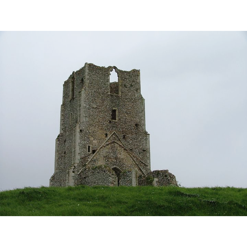
view of church exterior - north view
Scene Description: showing the remains of the tower and the little part of the north wall of the nave with the north entranceway
Copyright Statement: Image copyright © Simon Knott, 2005
Image Source: digital photograph May 2005 taken by Simon Knott [www.norfolkchurches.co.uk/egmere/egmere.htm] [accessed 11 December 2013]
Copyright Instructions: Standing permission
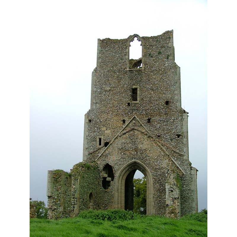
view of church exterior - southeast view
Scene Description: the chancel and most of the nave are now gone
Copyright Statement: Image copyright © Simon Knott, 2005
Image Source: digital photograph May 2005 taken by Simon Knott [www.norfolkchurches.co.uk/egmere/egmere.htm] [accessed 11 December 2013]
Copyright Instructions: Standing permission
view of church exterior - south view
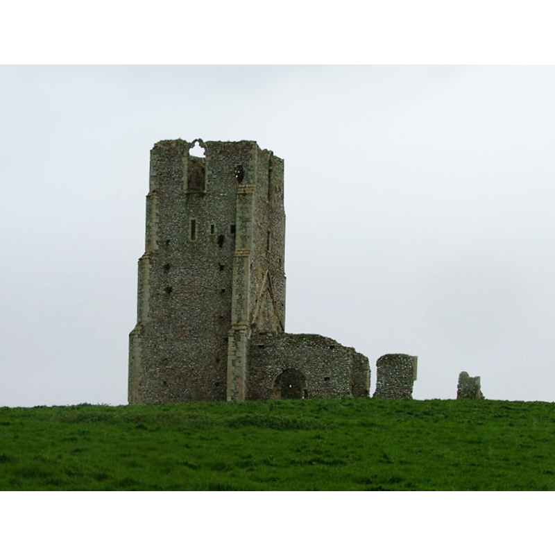
Scene Description: only part of the west tower and a little of the south wall of the nave remain
Copyright Statement: Image copyright © Simon Knott, 2005
Image Source: digital photograph May 2005 taken by Simon Knott [www.norfolkchurches.co.uk/egmere/egmere.htm] [accessed 11 December 2013]
Copyright Instructions: Standing permission
view of church exterior in context
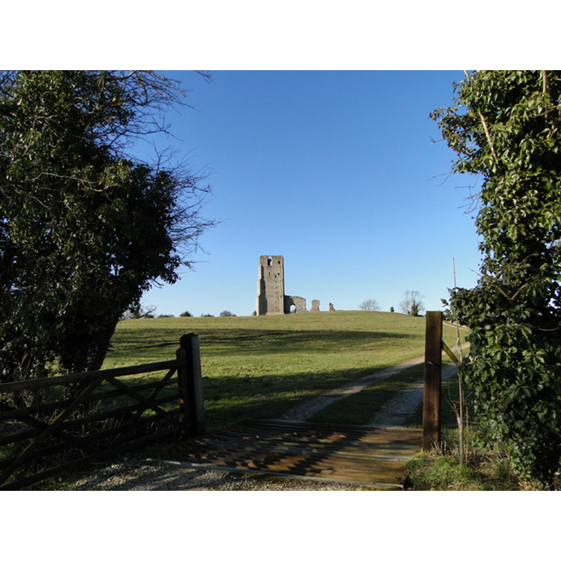
Scene Description: The village of Egmere disappeared in the 16th century
Copyright Statement: Image copyright © Adrian S Pye, 2010
Image Source: digital photograph taken 2 March 2010 by Adrian S Pye [www.geograph.org.uk/photo/2231758] [accessed 11 December 2013]
Copyright Instructions: CC-BY-SA-3.0
view of church interior - nave - looking west
Scene Description: the tower arch below the outline of the roof of the nave; on the left the south entranceway in the small part of the south wall that remains
Copyright Statement: Image copyright © Simon Knott, 2005
Image Source: digital photograph May 2005 taken by Simon Knott [www.norfolkchurches.co.uk/egmere/egmere.htm] [accessed 11 December 2013]
Copyright Instructions: Standing permission
INFORMATION
Font ID: 15041EGM
Object Type: Baptismal Font1?
Font Century and Period/Style: 13th century, Medieval
Church / Chapel Name: Parish Church of St. Edmund [in ruins]
Font Location in Church: [disappeared?]
Church Patron Saint(s): St. Edmund the Martyr [aka Edmund of East Anglia]
Church Address: [Egmere] Walsingham, Norfolk NR22 6BT
Site Location: Norfolk, East Anglia, England, United Kingdom
Directions to Site: The village of Egmere disappeared in the 16thC; the ruins of the church are located near North Barsham and Waterden, off (W) the Fakenham to Wells road, 5 km W of Walsingham
Ecclesiastic Region: [Diocese of Norwich]
Historical Region: Hundred of North Greehow
Additional Comments: disappeared font? (the one from the 13thC church here)
Font Notes:
Click to view
There are three entries for Egmere [variant spellings in the Domesday survey [http://domesdaymap.co.uk/place/TF8937/egmere/] [accessed 11 December 2013], but there is no mention of a church or cleric in any of them. Blomefield (1805-1810) reports on a transaction related to a 'moiety' of this church in 1277, and at the head of the list of rectors here, adds: "In 1299, Roger de Snetesham was instituted to a mediety, presented by the Bishop of Norwich". The church was already in ruins by Blomefield's time: "The Church is a rectory [...] and is now demolished, and the inhabitants go to the church of Waterden, and are there buried, &c. Sir Nicholas Bacon is said to have profaned it, and turned it into a barn. Here were anciently two medieties". [NB: we have no information on the font of the medieval church here].
COORDINATES
UTM: 31U 353241 5863370
Latitude & Longitude (Decimal): 52.899946, 0.81806
Latitude & Longitude (DMS): 52° 53′ 59.81″ N, 0° 49′ 5.02″ E
REFERENCES
- Blomefield, Francis, An essay towards a topographical history of Norfolk, 1805-1810, vol. 9: 223-226 / [www.british-history.ac.uk/report.aspx?compid=78532] [accessed 11 December 2013]
- Knott, Simon, The Norfolk Churches Site, Simon Knott, 2004. [standing permission to reproduce images received from Simon (February 2005]. URL: www.norfolkchurches.co.uk.