Denton nr. Harleston / / Dentuna
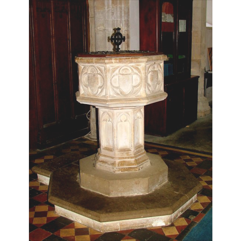
Image copyright © Simon Knott, 2009
Standing permission
Results: 8 records
R01: design element - motifs - moulding
Copyright Statement: Image copyright © Simon Knott, 2009
Image Source: digital photograph taken March 2006 by Simon Knott [http://www.norfolkchurches.co.uk/denton/denton.htm] [accessed 21 July 2009]
Copyright Instructions: Standing permission
UB01: design element - architectural - arch or window - trefoiled - 8
Copyright Statement: Image copyright © Simon Knott, 2009
Image Source: digital photograph taken March 2006 by Simon Knott [http://www.norfolkchurches.co.uk/denton/denton.htm] [accessed 21 July 2009]
Copyright Instructions: Standing permission
view of font and cover
Copyright Statement: Image copyright © Simon Knott, 2009
Image Source: digital photograph taken March 2006 by Simon Knott [http://www.norfolkchurches.co.uk/denton/denton.htm] [accessed 21 July 2009]
Copyright Instructions: Standing permission
symbol - shield - blank - in a quatrefoil - 8
Copyright Statement: Image copyright © Simon Knott, 2009
Image Source: digital photograph taken March 2006 by Simon Knott [http://www.norfolkchurches.co.uk/denton/denton.htm] [accessed 21 July 2009]
Copyright Instructions: Standing permission
design element - motifs - moulding
Copyright Statement: Image copyright © Simon Knott, 2009
Image Source: digital photograph taken March 2006 by Simon Knott [http://www.norfolkchurches.co.uk/denton/denton.htm] [accessed 21 July 2009]
Copyright Instructions: Standing permission
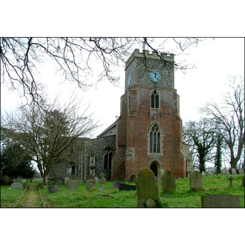
view of church exterior - northwest view
Copyright Statement: Image copyright © Simon Knott, 2009
Image Source: digital photograph taken March 2006 by Simon Knott [http://www.norfolkchurches.co.uk/denton/denton.htm] [accessed 21 July 2009]
Copyright Instructions: Standing permission
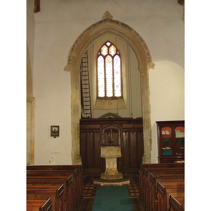
view of church interior - nave - looking west
Copyright Statement: Image copyright © Simon Knott, 2009
Image Source: digital photograph taken March 2006 by Simon Knott [http://www.norfolkchurches.co.uk/denton/denton.htm] [accessed 21 July 2009]
Copyright Instructions: Standing permission
design element - motifs - moulding - graded
Copyright Statement: Image copyright © Simon Knott, 2009
Image Source: digital photograph taken March 2006 by Simon Knott [http://www.norfolkchurches.co.uk/denton/denton.htm] [accessed 21 July 2009]
Copyright Instructions: Standing permission
INFORMATION
Font ID: 15019DEN
Object Type: Baptismal Font1
Font Century and Period/Style: 15th century, Perpendicular
Workshop/Group/Artisan: heraldic font
Church / Chapel Name: Parish Church of St. Mary
Font Location in Church: Inside the church, at the W end of the nave
Church Patron Saint(s): St. Mary the Virgin
Church Address: Denton Road, Denton, Norfolk IP20 0AA
Site Location: Norfolk, East Anglia, England, United Kingdom
Directions to Site: Located 6 km ENE of Harleston
Ecclesiastic Region: Diocese of Norwich
Historical Region: Hundred of Earsham
Additional Comments: disappeared font? (the one of the Domesday-time church here)
Font Notes:
Click to view
There are three entries for this Denton in the Domesday survey [http://domesdaymap.co.uk/place/TM2788/denton/] [accessed 23 July 2014], but neither mentions a church or cleric in it. Blomefield (1805-1810) writes: "This church is dedicated to the Virgin Mary, who had her image in the chancel, with a light burning before it. Domesday of Norwich tells us, that it was valued at 36 marks, that the rector had a house and carucate of land [...] The Church, chancel, two isles, and north porch, are leaded; the north vestry is down. At the west end stands a low square brick tower, in which there are three bells". Blomefield (ibid.) names as first recorded rector here "Will. de Brehull, chaplain to King Edw. I. who granted a prohibition in the 31st year of his reign, that no one should molest him for non-residence" [the 31st year of Edward I's reign would be 1303]. The present font is noted in Pevsner & Wilson (1999): "Octagonal, with shields in quatrefoils". Illustrated in Knott (2006). The basin has thick round mouldings at the upper rim and lower side; the octagonal stem has trefoiled arches or windows on the sides; the lower base is moulded. Two-step plinth, part of which is modern. The wooden font cover is octagonal and flat, with metal decoration and and cross finial; 19th-century? [NB: we have no information on the font of the Domesday-time church here].
Credit and Acknowledgements: We are grateful to Simon Knott, of www.norfolkchurches.co.uk, for his photographs of church and font
COORDINATES
UTM: 31U 388662 5810885
Latitude & Longitude (Decimal): 52.436811, 1.362146
Latitude & Longitude (DMS): 52° 26′ 12.52″ N, 1° 21′ 43.73″ E
MEDIUM AND MEASUREMENTS
Material: stone
Font Shape: octagonal, mounted
Basin Interior Shape: round
Basin Exterior Shape: octagonal
LID INFORMATION
Date: 19th-century?
Material: wood, oak?
Apparatus: no
Notes: [cf. FontNotes]
REFERENCES
- Blomefield, Francis, An essay towards a topographical history of Norfolk, 1805-1810, vol. 5: 405-416 / [www.british-history.ac.uk/report.aspx?compid=78198] [accessed 17 April 2013]
- Knott, Simon, The Norfolk Churches Site, Simon Knott, 2004. [standing permission to reproduce images received from Simon (February 2005]. URL: www.norfolkchurches.co.uk.
- Pevsner, Nikolaus, Norfolk 2: North-West and South (2nd ed.), London: Penguin, 1999, p. 278