Burston nr. Diss
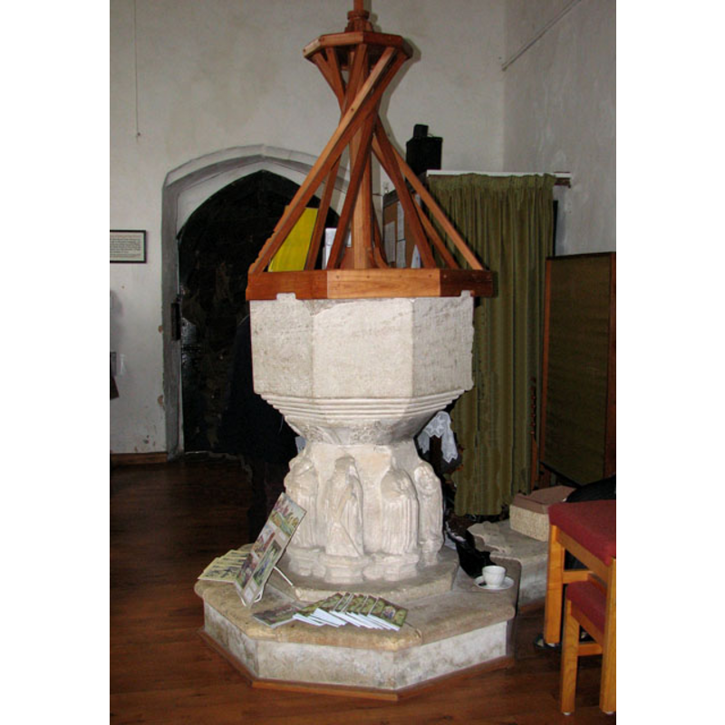
Image copyright © Evelyn Simak, 2010
CC-BY-SA-3.0
Results: 7 records
view of font and cover
Copyright Statement: Image copyright © Evelyn Simak, 2010
Image Source: digital photograph taken 27 March 2010 by Evelyn Simak [www.geograph.org.uk/photo/1773331] [accessed 12 February 2013]
Copyright Instructions: CC-BY-SA-3.0
design element - motifs - floral - 8
Copyright Statement: Image copyright © Evelyn Simak, 2010
Image Source: detail of a digital photograph taken 27 March 2010 by Evelyn Simak [www.geograph.org.uk/photo/1773331] [accessed 12 February 2013]
Copyright Instructions: CC-BY-SA-3.0
design element - motifs - moulding - graded
Copyright Statement: Image copyright © Evelyn Simak, 2010
Image Source: detail of a digital photograph taken 27 March 2010 by Evelyn Simak [www.geograph.org.uk/photo/1773331] [accessed 12 February 2013]
Copyright Instructions: CC-BY-SA-3.0
view of church exterior - northeast view
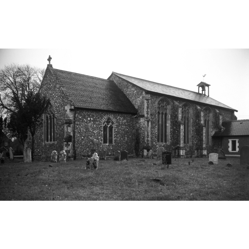
Scene Description: Photo caption: "The Norman round tower fell in 1753"
Copyright Statement: Image copyright © George Plunkett, 2014
Image Source: B&W photograph taken 26 November 1995 by George Plunkett [www.georgeplunkett.co.uk/Norfolk/B/Burston St Mary's church from NE [7296] 1995-11-26.jpg] [accessed 22 January 2014]
Copyright Instructions: Standing permission by Jonathan Plunkett
view of church exterior - southwest view
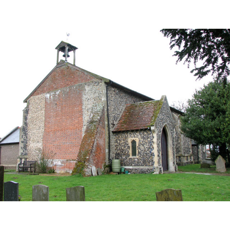
Copyright Statement: Image copyright © Evelyn Simak, 2010
Image Source: digital photograph taken 27 March 2010 by Evelyn Simak [www.geograph.org.uk/photo/1773291] [accessed 12 February 2013]
Copyright Instructions: CC-BY-SA-3.0
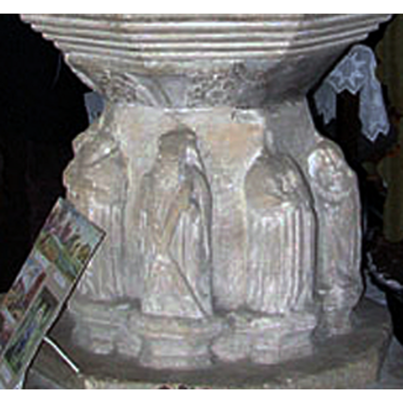
Apostle or saint - saints? - 8
Scene Description: [Including Andrew holding a saltire cross [cf. FontNotes]
Copyright Statement: Image copyright © Evelyn Simak, 2010
Image Source: detail of a digital photograph taken 27 March 2010 by Evelyn Simak [www.geograph.org.uk/photo/1773331] [accessed 12 February 2013]
Copyright Instructions: CC-BY-SA-3.0
view of church interior - nave - looking northwest

Copyright Statement: Image copyright © ACRE, 2007
Image Source: digital photograph in ACRE [www.acre.org.uk/communityassets_churches_casestudies.html] [accessed 20 July 2009] -- Image copyright © ACRE, 2007
Copyright Instructions: PERMISSION NOT AVAILABLE -- IMAGE NOT FOR PUBLIC USE
INFORMATION
Font ID: 15011BUR
Object Type: Baptismal Font1
Font Century and Period/Style: 15th century, Perpendicular
Church / Chapel Name: Parish Church of St. Mary [aka The Blessed Virgin]
Font Location in Church: Inside the church, at the W end of the nave
Church Patron Saint(s): St. Mary the Virgin
Church Notes: round-tower church
Church Address: Diss Rd., Burston and Shimpling, Norfolk IP22 5TP
Site Location: Norfolk, East Anglia, England, United Kingdom
Directions to Site: Located 5 km NNE of Diss
Ecclesiastic Region: Diocese of Norwich
Historical Region: Hundred of Diss
Additional Comments: disappeared font? (the one from the original 12thC church here)
Font Notes:
Click to view
Blomefield (1805-1810) reports a church "dedicated to the Blessed Virgin [...] a rectory [...] appropriated by John of Oxford, Bishop of Norwich, to Butley priory", with a rector name Wybart before 1299; the said rectory, adds Blomefield (ibid.), "being given them by King Henry I at their founder's request, before he gave the manor to the Fitz-Walters." [NB: Henry I reigned 1100-1135]. Described in Pevsner & Wilson (1999): "C15. Round the stem, not in niches, eight figures, quite good." Illustrated in ACRE [www.acre.org.uk/communityassets_churches_casestudies.html] [accessed 20 July 2009]. The octagonal basin appears plain [has it been re-cut?] but has floral motifs on the underbowl; the carving of protruding figures here is a rare case in fonts of the area; the eight figures, raised on little polygonal pedestals, have had their heads broken off; one of the figures is easily identified as Andrew, the Apostle, by the saltire cross he holds; the font is raised on an octagonal plinth. The wooden cover is a modern abstract rendering of the Jacobean traditional desing; strange.
COORDINATES
UTM: 31U 373484 5807718
Latitude & Longitude (Decimal): 52.405056, 1.14018
Latitude & Longitude (DMS): 52° 24′ 18.2″ N, 1° 8′ 24.65″ E
MEDIUM AND MEASUREMENTS
Material: stone
Font Shape: octagonal, mounted
Basin Interior Shape: round
Basin Exterior Shape: octagonal
LID INFORMATION
Date: modern
Material: wood
Apparatus: no
Notes: [cf. FontNotes]
REFERENCES
- Blomefield, Francis, An essay towards a topographical history of Norfolk, 1805-1810, vol. 1: 125-130 / [www.british-history.ac.uk/report.aspx?compid=77100] [accessed 12 February 2013]
- Pevsner, Nikolaus, Norfolk 2: North-West and South (2nd ed.), London: Penguin, 1999, p. 236