Twyford nr. Fakenham
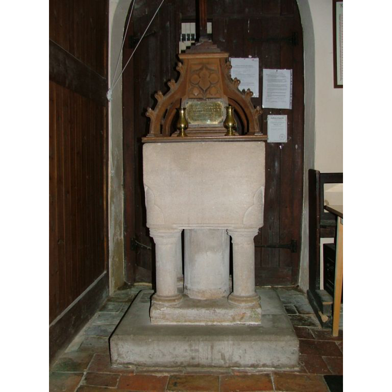
Image copyright © Simon Knott, 2006
Standing permission
Results: 3 records
view of font and cover
Scene Description: the modern font and cover
Copyright Statement: Image copyright © Simon Knott, 2006
Image Source: digital photograph July 2006 taken by Simon Knott [www.norfolkchurches.co.uk/twyford/twyford.htm] [accessed 31 October 2013]
Copyright Instructions: Standing permission
view of church exterior - southwest view
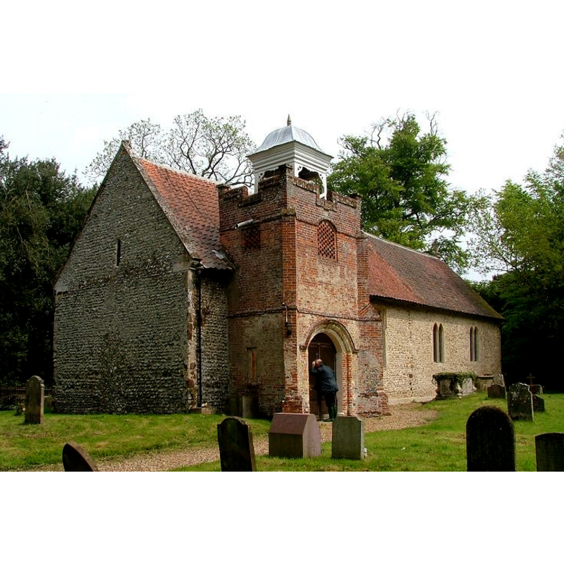
Copyright Statement: Image copyright © Simon Knott, 2006
Image Source: digital photograph July 2006 taken by Simon Knott [www.norfolkchurches.co.uk/twyford/twyford.htm] [accessed 31 October 2013]
Copyright Instructions: Standing permission
view of church exterior - southwest view
![Photo caption: "The west wall of the nave has a Norman slit. The brick south porch tower is dated 1757. It has a wooden cupola"
PHOTOS digital photograph July 2006 taken by Simon Knott [www.norfolkchurches.co.uk/twyford/twyford.htm] [accessed 31 October 2013]](/static-50478a99ec6f36a15d6234548c59f63da52304e5/compressed/1131103061_compressed.png)
Scene Description: Photo caption: "The west wall of the nave has a Norman slit. The brick south porch tower is dated 1757. It has a wooden cupola"
PHOTOS digital photograph July 2006 taken by Simon Knott [www.norfolkchurches.co.uk/twyford/twyford.htm] [accessed 31 October 2013]
Copyright Statement: Image copyright © George Plunkett, 2013
Image Source: B&W photograph taken 19 September 1992 by George Plunkett [www.georgeplunkett.co.uk/Norfolk/T/Twyford St Nicholas' church from SW [6910] 1992-09-19.jpg] [accessed 31 October 2013]
Copyright Instructions: Standing permission by Jonathan Plunkett
INFORMATION
Font ID: 14950TWY
Object Type: Baptismal Font1?
Font Century and Period/Style: 12th - 13th century, Medieval
Church / Chapel Name: Parish Church of St. Nicholas
Church Patron Saint(s): St. Nicholas of Myra
Church Address: Twyford, Norfolk NR20 5LY
Site Location: Norfolk, East Anglia, England, United Kingdom
Directions to Site: Located on the A1067, 12 km SE of Fakenham, 30 km NW of Norwich
Ecclesiastic Region: Diocese of Norwich
Historical Region: Hundred of Eynford
Additional Comments: disappeared font?
Font Notes:
Click to view
Blomefield (1805-1810) notes: "This town is not mentioned in Domesday Book, being accounted for under the lordship of Walter Giffard Earl of Bucks, in Bintre, and under the lordship of Swanton in Folsham"; the church, described as "a single pile without a steeple, but there is a shed in the churchyard for 3 bells", is documented by 1309 with the first recorded recotor, "John de Byntre, by Robert, son of Bartholomew de Byntre". It may well have existed in earlier times but Blomefield (ibid.) gives no earlier evidence. Bell (1927) lists an 1839 water-colour drawing of this font by Miles Edmund Cotman in the Bulwer Collection. The present baptismal font may hark back at a Norman style, but the manufacture is 19th-century; it consists of a square block basin, plain but for a threfoil at each lower angle; raised on a central shaft and four detached angle columns, all round, a square lower base and a square plinth. The wooden cover has a aquare base with raised scroll ribs with crockets; probably contemporary with the Victorian font. [NB: we have no information on the earlier font(s) of the medieval church, nor have we been able to see the 1839 water-colour by Cotman]
COORDINATES
UTM: 31U 364361 5849797
Latitude & Longitude (Decimal): 52.78093, 0.98892
Latitude & Longitude (DMS): 52° 46′ 51.35″ N, 0° 59′ 20.11″ E
LID INFORMATION
Date: 19th-century?
Material: wood
Notes: [cf. FontNotes]
REFERENCES
- Bell, C.F., Miles Edmund Cotman (1810-1858): with a catalogue of fifty drawings by him, selected from the Bulwer Collection, London: Walker's Galleries, [1927?], p. 34
- Blomefield, Francis, An essay towards a topographical history of Norfolk, 1805-1810, vol. 8: 282-285 / [www.british-history.ac.uk/report.aspx?compid=78467] [accessed 31 October 2013]
- Knott, Simon, The Norfolk Churches Site, Simon Knott, 2004. [standing permission to reproduce images received from Simon (February 2005]. URL: www.norfolkchurches.co.uk.