Tunstall nr. Yarmouth / Tunestall / Tunestalle / Tunestaneten / Tunstal
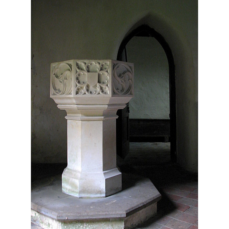
Image copyright © Evelyn Simak, 2008
CC-BY-SA-3.0
Results: 7 records
view of font
Scene Description: Photo caption: "The 15th century font has been recut. The doorway seen at right leads into the vestry"
Copyright Statement: Image copyright © Evelyn Simak, 2008
Image Source: digital photograph taken 28 May 2008 by Evelyn Simak [www.geograph.org.uk/photo/820743] [accessed 14 May 2014]
Copyright Instructions: CC-BY-SA-3.0
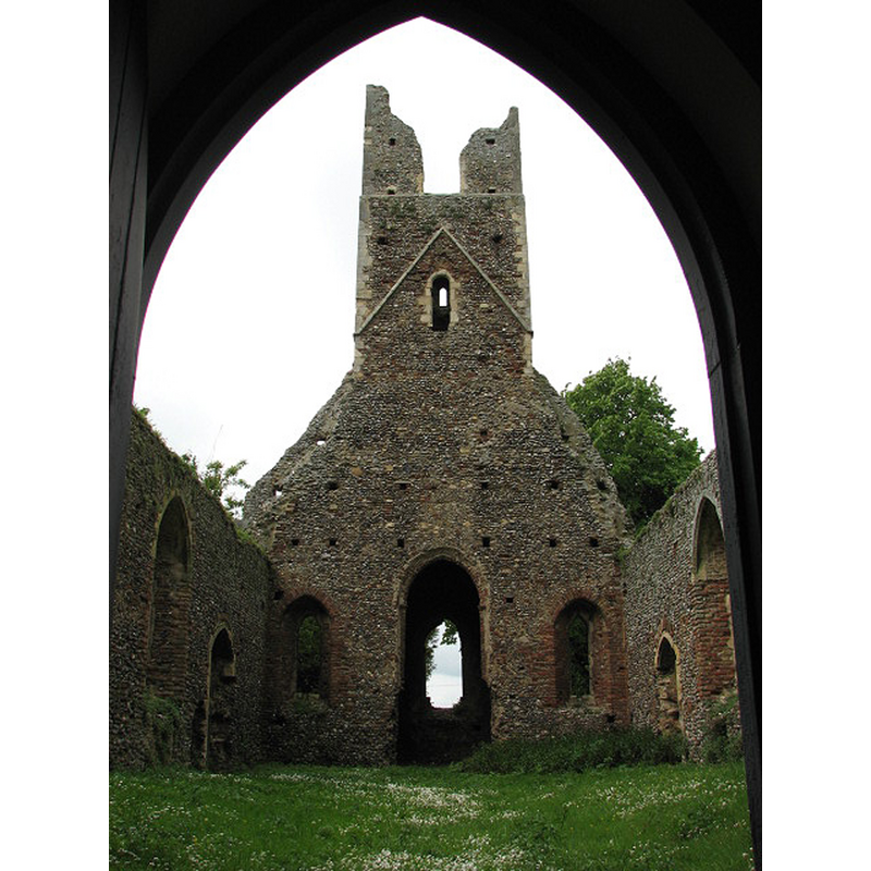
view of church exterior - west end
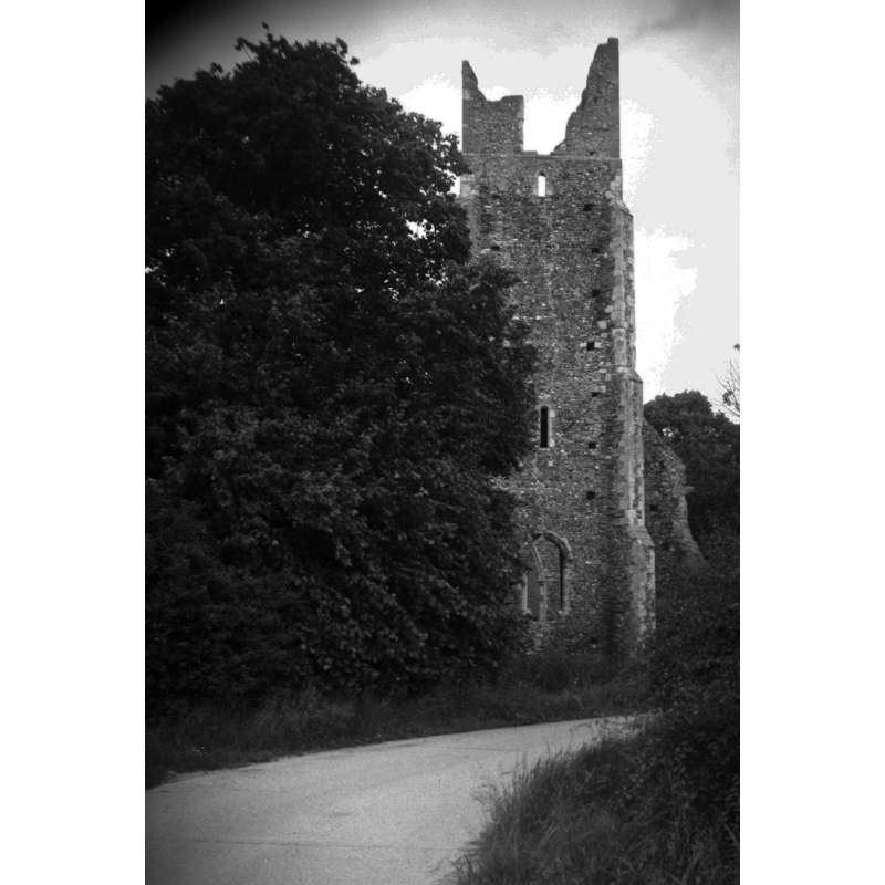
Scene Description: Photo caption: "Ruin from the west"
Copyright Statement: Image copyright © George Plunkett, 2014
Image Source: B&W photograph taken 26 June 1993 by George Plunkett [www.georgeplunkett.co.uk/Norfolk/T/Tunstall Ss Peter and Paul church tower [7018] 1993-06-26.jpg] [accessed 14 May 2014]
Copyright Instructions: Standing permission by Jonathan Plunkett
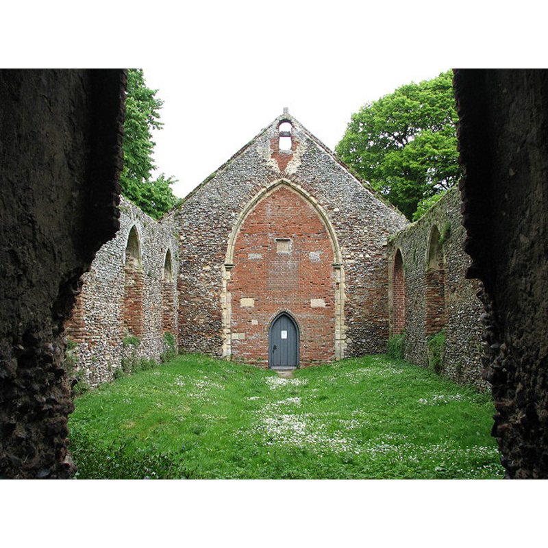
view of church exterior - southeast view
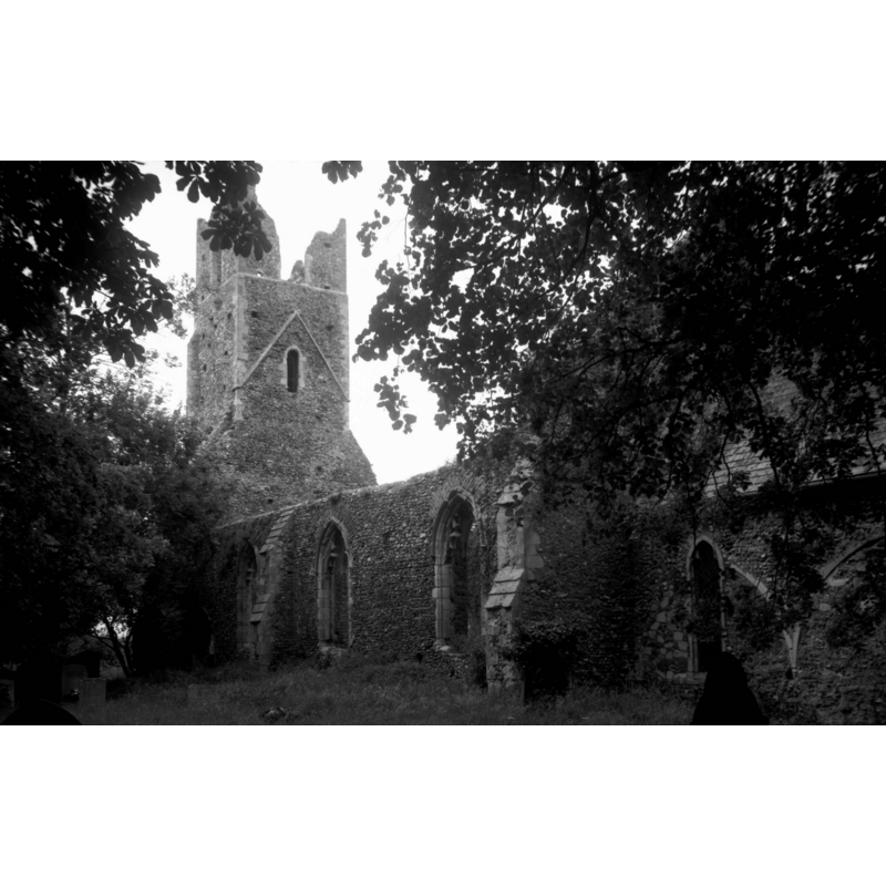
Scene Description: Photo caption: "All in ruin except the chancel which remains in use. The chancel arch blocked in 1705. 14c windows to nave"
Copyright Statement: Image copyright © George Plunkett, 2014
Image Source: B&W photograph taken 26 June 1993 by George Plunkett [www.georgeplunkett.co.uk/Norfolk/T/Tunstall Ss Peter and Paul church from SE [7017] 1993-06-26.jpg] [accessed 14 May 2014]
Copyright Instructions: Standing permission by Jonathan Plunkett
view of church interior - chancel - looking west
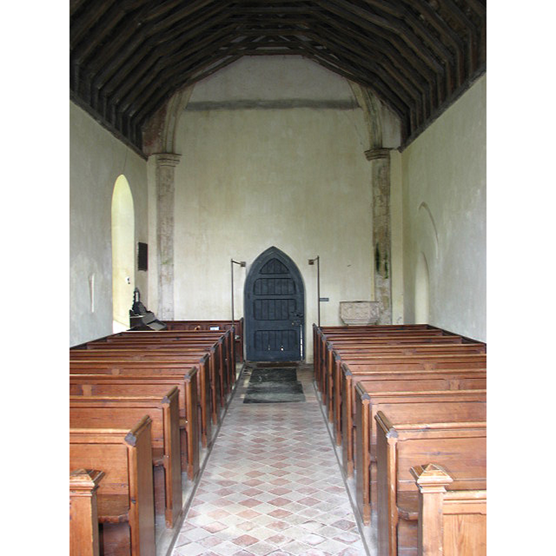
Scene Description: the chancel now serves as nave of the reduced church
Copyright Statement: Image copyright © Evelyn Simak, 2008
Image Source: digital photograph taken 28 May 2008 by Evelyn Simak [www.geograph.org.uk/photo/820762] [accessed 14 May 2014]
Copyright Instructions: CC-BY-SA-3.0
view of church interior - chancel - looking east
Scene Description: the chancel now serves as nave of the reduced church
Copyright Statement: Image copyright © Evelyn Simak, 2008
Image Source: Idigital photograph taken 28 May 2008 by Evelyn Simak [www.geograph.org.uk/photo/820732] [accessed 14 May 2014]
Copyright Instructions: CC-BY-SA-3.0
view of church interior - nave - looking west
Scene Description: Photo caption: "Looking west across nave towards the ruined tower, from chancel doorway"
Copyright Statement: Image copyright © Evelyn Simak, 2008
Image Source: digital photograph taken 28 May 2008 by Evelyn Simak [www.geograph.org.uk/photo/820777] [accessed 14 May 2014]
Copyright Instructions: CC-BY-SA-3.0
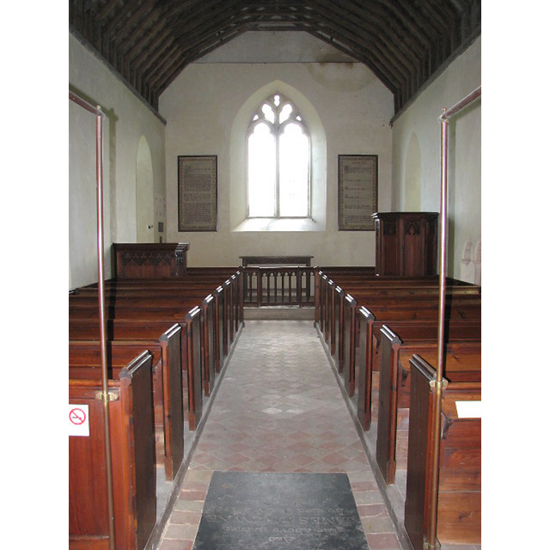
view of church interior - nave - looking east
Scene Description: Photo caption: "Looking east across nave towards bricked up chancel arch and doorway leading into chancel
Copyright Statement: Image copyright © Evelyn Simak, 2008
Image Source: digital photograph taken 28 May 2008 by Evelyn Simak [www.geograph.org.uk/photo/820783] [accessed 14 May 2014]
Copyright Instructions: CC-BY-SA-3.0
INFORMATION
Font ID: 14947TUN
Object Type: Baptismal Font1
Font Century and Period/Style: 14th - 15th century [re-cut?] / 19th century, Medieval? / Victorian?
Church / Chapel Name: Parish Church of St. Peter and St. Paul
Font Location in Church: Inside the semi-ruinous church, at the W end of the nave, N side
Church Patron Saint(s): St. Peter & St. Paul
Church Notes: church fell into disrepair ca. 1700; repaired in 1850s; declared redundant in 1980
Church Address: Low Farm Road, Halvergate, Norfolk NR13 3PS
Site Location: Norfolk, East Anglia, England, United Kingdom
Directions to Site: Located 6 km N of Reedham, 13 km W of Yarmouth
Ecclesiastic Region: Diocese of Norwich
Historical Region: Hundred of Walsham
Additional Comments: altered font? (the 14th-15thC font re-cut?) -- disappeared font? (the one from the Domesday-time church here)
Font Notes:
Click to view
There are four entries for this Tunstall [variant spelling] in the Domesday survey [http://domesdaymap.co.uk/place/TG4108/tunstall/] [accessed 14 May 2014], the part under the lordship of Eudo the stewart in 1086 reporting a church and churchlands in it. Blomefield (1805-1810) transcribes the Domesday entry related to the church: "a church with 8 acres of glebe"; of the church Blomefield (ibid.) writes: "The Church is dedicated to St. Peter and St. Paul, and was rectory [...] and granted about the reign of Richard I [i.e., 1189-1199] to the abbey of Sibton in Suffolk, by Robert Fitz Roger, [...] and after a vicarage was settled on its being appropriated". Pevsner & Wilson (1997) write: "Octagonal, with simple tracery patterns, including a wheel of three mouchettes, either 1853 or completely redone." The present font looks totally new from the outside [closer inspection not available to us now], so we are unable to establish whether it has been totally re-cut and re-carved, or it is a modern font. [NB: we have no information on the font of the Domesday-time church here].
Credit and Acknowledgements: We are grateful to Jonathan Plunkett for the photographs of this church taken by his father, George Plunkett, in June 1993
COORDINATES
UTM: 31U 403112 5830580
Latitude & Longitude (Decimal): 52.61657, 1.568902
Latitude & Longitude (DMS): 52° 36′ 59.65″ N, 1° 34′ 8.05″ E
MEDIUM AND MEASUREMENTS
Material: stone
Font Shape: octagonal, mounted
Basin Interior Shape: round
Basin Exterior Shape: octagonal
REFERENCES
- Blomefield, Francis, An essay towards a topographical history of Norfolk, 1805-1810, vol. 11: 117-121 / [www.british-history.ac.uk/report.aspx?compid=78764] [accessed 14 May 2014]
- Knott, Simon, The Norfolk Churches Site, Simon Knott, 2004. [standing permission to reproduce images received from Simon (February 2005]. URL: www.norfolkchurches.co.uk.
- Pevsner, Nikolaus, Norfolk 1: Norwich and North-East [2nd ed.], Harmondsworth: Penguin Books, 1997, p. 702