Haveringland / Heveringalanda / Heverland
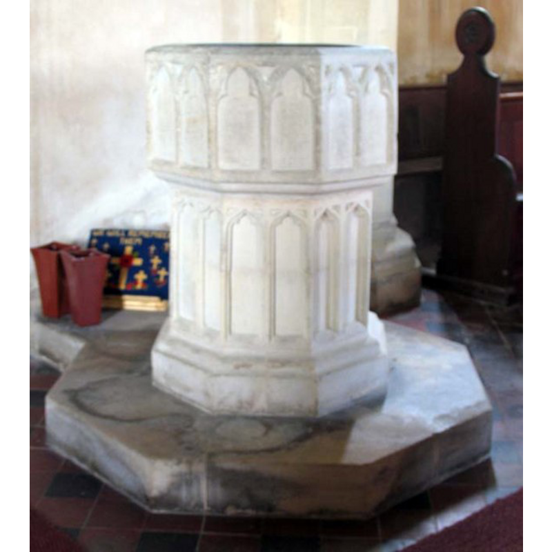
Image copyright © John Salmon, 2007
CC-BY-SA-3.0
Results: 5 records
design element - architectural - arcade - blind - trefoiled arches - 16 arches
Copyright Statement: Image copyright © John Salmon, 2007
Image Source: digital photograph taken 4 June 2007 by John Salmon [www.geograph.org.uk/photo/475001] [accessed 4 October 2013]
Copyright Instructions: CC-BY-SA-3.0
view of church exterior - southwest end
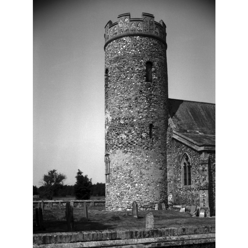
Scene Description: Photo caption: "The round tower is Norman, the rest was rebuilt in 1845"
Copyright Statement: Image copyright © George Plunkett, 2013
Image Source: B&W photograph taken 21 June 1992 by George Plunkett [www.georgeplunkett.co.uk/Norfolk/H/Haveringland St Peter's church tower [6851] 1992-06-21.jpg] [accessed 4 October 2013]
Copyright Instructions: Standing permission by Jonathan Plunkett
view of church exterior - southeast view
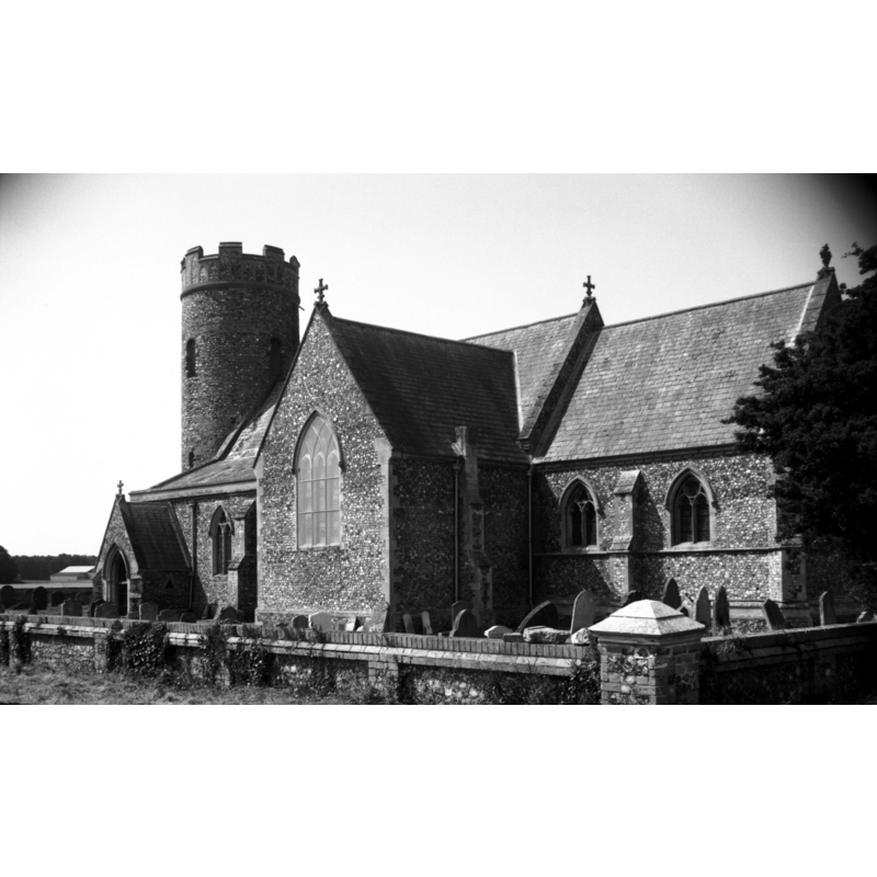
Scene Description: Photo caption: "In a desolate position, more or less on an abandoned airfield"
Copyright Statement: Image copyright © George Plunkett, 2013
Image Source: B&W photograph taken 21 June 1992 by George Plunkett [www.georgeplunkett.co.uk/Norfolk/H/Haveringland St Peter's church from SE [6852] 1992-06-21.jpg] [accessed 4 October 2013]
Copyright Instructions: Standing permission by Jonathan Plunkett
view of church interior - nave - looking east
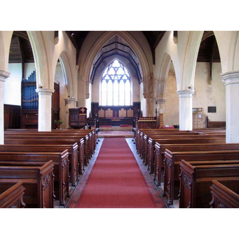
Copyright Statement: Image copyright © John Salmon, 2007
Image Source: digital photograph taken 4 June 2007 by John Salmon [www.geograph.org.uk/photo/475012] [accessed 4 October 2013]
Copyright Instructions: CC-BY-SA-3.0
design element - architectural - arcade - blind - trefoiled arches - 16 arches
Scene Description: on the 19th-century base
Copyright Statement: Image copyright © John Salmon, 2007
Image Source: digital photograph taken 4 June 2007 by John Salmon [www.geograph.org.uk/photo/475001] [accessed 4 October 2013]
Copyright Instructions: CC-BY-SA-3.0
INFORMATION
Font ID: 14884HAV
Object Type: Baptismal Font1
Font Century and Period/Style: 13th century [basin only] [composite font], Medieval [composite]
Church / Chapel Name: Parish Church of St. Peter
Font Location in Church: Inside the church, at the W end of the nave
Church Patron Saint(s): St. Peter
Church Notes: round-tower church
Church Address: Haveringland, Norfolk NR10 4PW
Site Location: Norfolk, East Anglia, England, United Kingdom
Directions to Site: Located near Aylsham, 13 km NW of Norwich, within Haveribgland Estate/Hall Park
Ecclesiastic Region: Diocese of Norwich
Historical Region: Hundred of Eynford
Additional Comments: composite font (the present one: 13thC basin on a 19thC base) -- disappeared font? (the one from the pre-Conquest church here)
Font Notes:
Click to view
Blomefield (1805-1810) writes: "Heverland. Called in Domesday Book, Heveringalanda, was the lordship of Goodwin Earl of Kent, (though styled a freeman only,) and father of King Harold: in the reign of the Confessor, [...] a church belonged to it with 10 acres, and was granted by King William I. to Rainald, son of Ivo, lord at the survey." Blomefield (ibid.) adds: "The Church is dedicated to St. Peter," This author (ibid.) further reports the existence of "Mountjoy Priory Manor and Priory [...] founded by William de Gyney, lord of Heverland, in a place there called Thweyt, about the reign of King Richard I [i.e., 1199-1216] [...] Newcourt says that the brethren or fraternity of Mountjoy was an order of knighthood established at Jerusalem, by Pope Alexander III. and confirmed in 1185, under St. Basil's rule: [...] but this priory is generally said to have been for canons of the order of St. Austin, and the patronage was always in the lords of this manor. [...] It was suppressed in 1528, before the general dissolution, by a bull of Pope Clement [...] The priory was dedicated to the Virgin Mary, St. Michael and St. Laurence, and stood about a mile south-west of the parish church." The present font of the parish church here is noted in Pevsner & Wilson (1997): "Octagonal C13 bowl with flat cusped arches; C19 stem." Illustrated in Knott (2005). The basin has a pair of blank trefoiled arches on each side; the replacement base, also octagonal, was made to replicate the design of the basin. On an octagonal plinth with kneeling extension. [NB: we have no information on the font from the pre-Conquest church here].
Credit and Acknowledgements: We are grateful to Jonathan Plunkett for the photographs of this church taken by his father, George Plunkett, in June 1992
COORDINATES
UTM: 31U 377552 5845252
Latitude & Longitude (Decimal): 52.743239, 1.186091
Latitude & Longitude (DMS): 52° 44′ 35.66″ N, 1° 11′ 9.93″ E
MEDIUM AND MEASUREMENTS
Material: stone
Font Shape: octagonal, mounted
Basin Interior Shape: round
Basin Exterior Shape: octagonal
REFERENCES
- Blomefield, Francis, An essay towards a topographical history of Norfolk, 1805-1810, vol. 8: 226-234 / [www.british-history.ac.uk/report.aspx?compid=78454] [accessed 4 October 2013]
- Knott, Simon, The Norfolk Churches Site, Simon Knott, 2004. [standing permission to reproduce images received from Simon (February 2005]. URL: www.norfolkchurches.co.uk.
- Pevsner, Nikolaus, Norfolk 1: Norwich and North-East [2nd ed.], Harmondsworth: Penguin Books, 1997, p. 543