Long Sutton nr. Farnham / Launge Sutton / Sheep Sutton / Sudtune
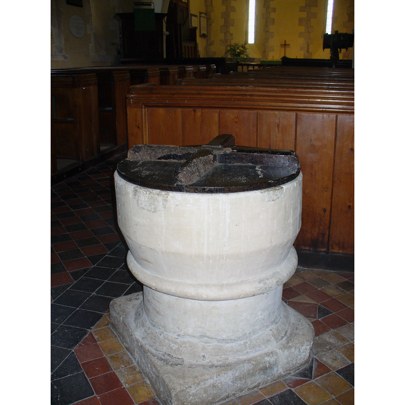
Image copyright © Colin Smith, 2010
CC-BY-SA-2.0
Results: 5 records
view of font and cover - southwest side
Scene Description: there are two repairs visible at the upper rim
Copyright Statement: Image copyright © Colin Smith, 2010
Image Source: digital photograph taken 20 June 2010 by Colin Smith [www.geograph.org.uk/photo/1926315] [accessed 31 July 2018]
Copyright Instructions: CC-BY-SA-2.0
view of font and cover - northwest side
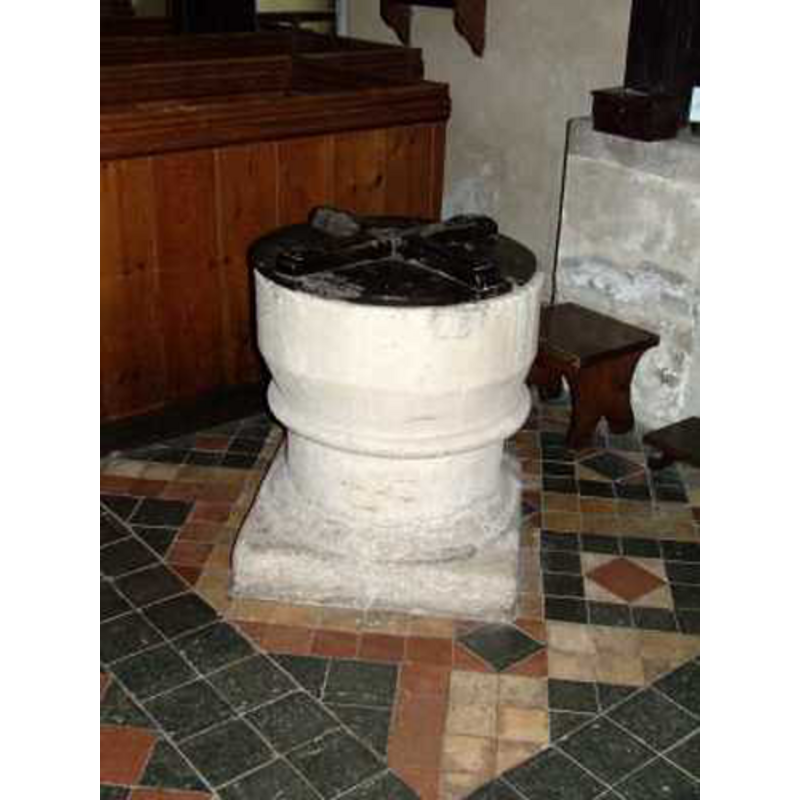
Copyright Statement: Image copyright © Chris Hayley, 2009
Image Source: digital photograph taken by Chris Hayley
Copyright Instructions: Standing permission
design element - motifs - roll moulding
Copyright Statement: Image copyright © Colin Smith, 2010
Image Source: digital photograph taken 20 June 2010 by Colin Smith [www.geograph.org.uk/photo/1926315] [accessed 31 July 2018]
Copyright Instructions: CC-BY-SA-2.0
view of church exterior - north view
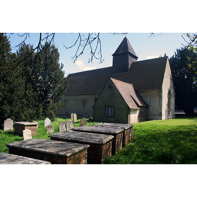
Copyright Statement: Image copyright © Brendan and Ruth McCartney, 2005
Image Source: digital photograph taken 18 April 2005 by Brendan and Ruth McCartney [www.geograph.org.uk/photo/4464] [accessed 31 July 2018]
Copyright Instructions: CC-BY-SA-2.0
view of church interior - chancel
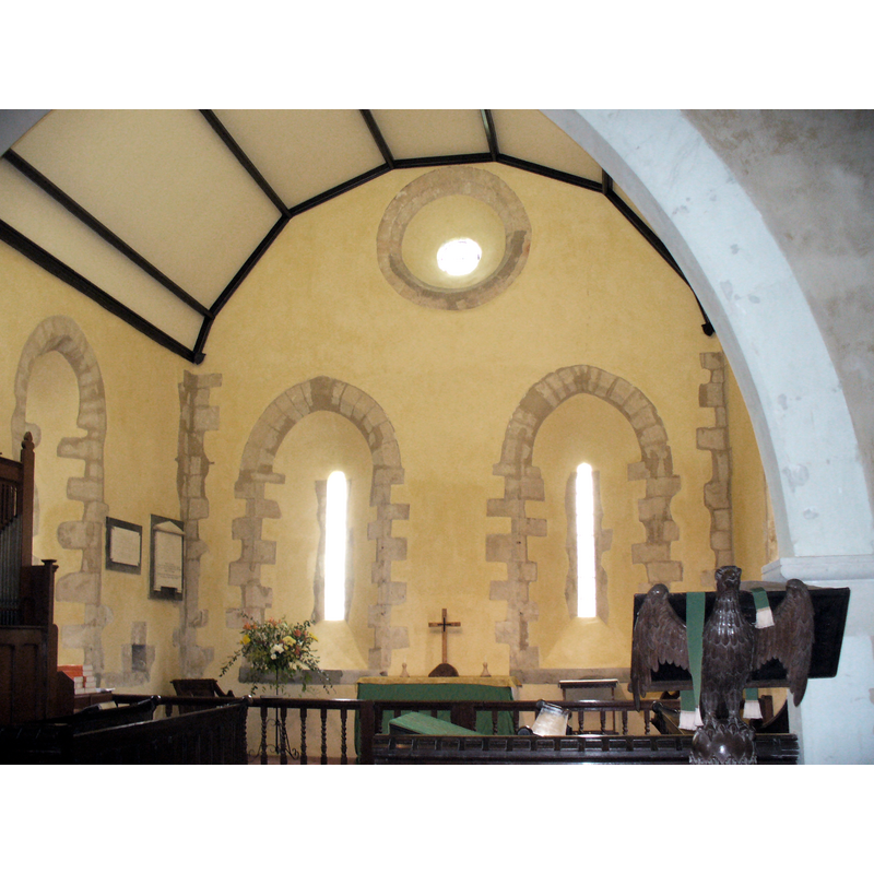
Scene Description: Source caption: "Inside All Saints, Long Sutton. View towards the Norman windows on the east wall of the village's 13th century church."
Copyright Statement: Image copyright © Brendan and Ruth McCartney, 2005
Image Source: digital photograph taken 20 June 2010 by Colin Smith [www.geograph.org.uk/photo/1926325] [accessed 31 July 2018]
Copyright Instructions: CC-BY-SA-2.0
INFORMATION
Font ID: 14756SUT
Object Type: Baptismal Font1
Font Century and Period/Style: 12th century, Late Norman
Church / Chapel Name: Parish Church of All Saints
Font Location in Church: Inside the church, at the W end, S side
Church Patron Saint(s): All Saints
Church Address: The Street, Long Sutton RG29 1ST, UK -- Tel.: 01256 861758
Site Location: Hampshire, South East, England, United Kingdom
Directions to Site: Located off (E) the B3349, 5 km S of Odiham, 7-8 km W of Farnham
Ecclesiastic Region: Diocese of Winchester [Guildford?]
Historical Region: Hundred of Crondall
Additional Comments: altered font (the present font: scraped, white-washed) -- disappeared font? (the one from the Domesday-time church here)
Font Notes:
Click to view
There is an entry for this [Long] Sutton [variant spelling] in the Domesday survey [http://opendomesday.org/place/SU7347/long-sutton/] [accessed 31 July 2018]; it reports a church in it. The Victoria County History (Hampshire, vol. 4, 1911) notes: "A chapel probably existed at Long Sutton at an early date and was served from Crondall Church. The exact date at which a perpetual curate was appointed by the hospital of St. Cross, Winchester, is uncertain [...] The nave and chancel, in one range without any structural division, the chancel arch being entirely modern, are of early 13th-century date, and the south chapel was added towards the end of the same century [...] The font is circular with a plain bowl cut down and scraped, and a heavy circular stem. It is perhaps of 12th-century date." The entry for this church in Historic England [Listing NGR: SU7391647347] reports a font in it; no further details given. There is a roll moulding at the centre ring position, where the underbowl chamfer meets the stem.
Credit and Acknowledgements: We are grateful to Chris Hayley, of www.southernlife.org.uk, for his photograph of this font
COORDINATES
UTM: 30U 643621 5676400
Latitude & Longitude (Decimal): 51.2209, -0.943362
Latitude & Longitude (DMS): 51° 13′ 15.24″ N, 0° 56′ 36.1″ W
MEDIUM AND MEASUREMENTS
Material: stone
Font Shape: cylindrical, mounted
Basin Interior Shape: round
Basin Exterior Shape: round
LID INFORMATION
Material: wood
Apparatus: no
Notes: round and flat, with flat cross on top
REFERENCES
- Victoria County History [online], University of London, 1993-. URL: https://www.british-history.ac.uk.