Yaverland / Awerlond / Everelant / Everlond / Evreland / Ewerelande / Ewrlaund / Yoverlond
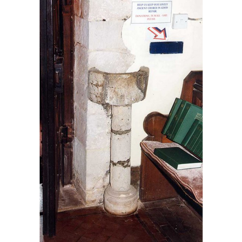
Image copyright © John Salmon, 2009
CC-BY-SA-3.0
Results: 1 records
view of stoup
Copyright Statement: Image copyright © John Salmon, 2009
Image Source: digital photograph taken 9 August 1999 by John Salmon [http://www.geograph.org.uk/photo/1154834] [accessed 11 May 2009]
Copyright Instructions: CC-BY-SA-3.0
INFORMATION
Font ID: 14626YAV
Object Type: Stoup
Font Century and Period/Style: 15th century, Perpendicular
Cognate Fonts: similar to the one at St. Lawrence, also on Isle of Wight
Church / Chapel Name: Parish Church of St. John the Baptist
Font Location in Church: [cf. FontNotes]
Church Patron Saint(s): St. John the Baptist
Church Address: Yaverland Rd, Yaverland, Isle of Wight PO36 8QW, UK
Site Location: Isle of Wight, South East, England, United Kingdom
Directions to Site: Located just N of Sandown
Ecclesiastic Region: Diocese of Portsmouth
Historical Region: Hundred of East Medine / Hundred of Bowcombe [in Domesday] -- formerly Hampshire
Additional Comments: disused stoup / restored stoup -- disappeared font? (the one from the 12thC church here)
Font Notes:
Click to view
There are two entries for Yaverland [variant spellings] in the Domesday survey [https://opendomesday.org/place/SZ6185/yaverland/] [accessed 18 February 2020] neither of which mentions cleric or church in it. Cox (1911) mentions a major restoration of this church in 1887-1889 and notes: "During the restoration an interesting object was brought to light, namely a detached holy-water stoup, after the fashion of a small font; it much resembles the one at St. Laurence's, save that the shaft is circular instead of octagonal, and was intended to stand against a wall." The Victoria County History (Hampshire, vol. 5, 1912) notes: "The church of St. Jon Baptist was one of the memorial chapel type, an aiseless nave and chancel separated by an arch of good Romanesque detail. It was built in the 12th century, probably by one of the de Aula family, and is primarily all of one date, circa 1150." There is no mention of a font in the VCH entry. [NB: we have no information on the original font of this church]
COORDINATES
UTM: 30U 631946 5614761
Latitude & Longitude (Decimal): 50.669722, -1.132778
Latitude & Longitude (DMS): 50° 40′ 11″ N, 1° 7′ 58″ W
MEDIUM AND MEASUREMENTS
Material: stone
Font Shape: cylindrical, wall-mounted with pedestal
Basin Interior Shape: round
Basin Exterior Shape: round
REFERENCES
- Victoria County History [online], University of London, 1993-. URL: https://www.british-history.ac.uk.
- Cox, John Charles, Isle of Wight: its churches and religious houses, London: G. Allen & Sons, 1911, p. 176 / [http://www.archive.org/stream/isleofwightitsch00coxjuoft/isleofwightitsch00coxjuoft_djvu.txt] [accessed 11 May 2009]