Mentmore / Mantemore / Mentemor / Mentemore
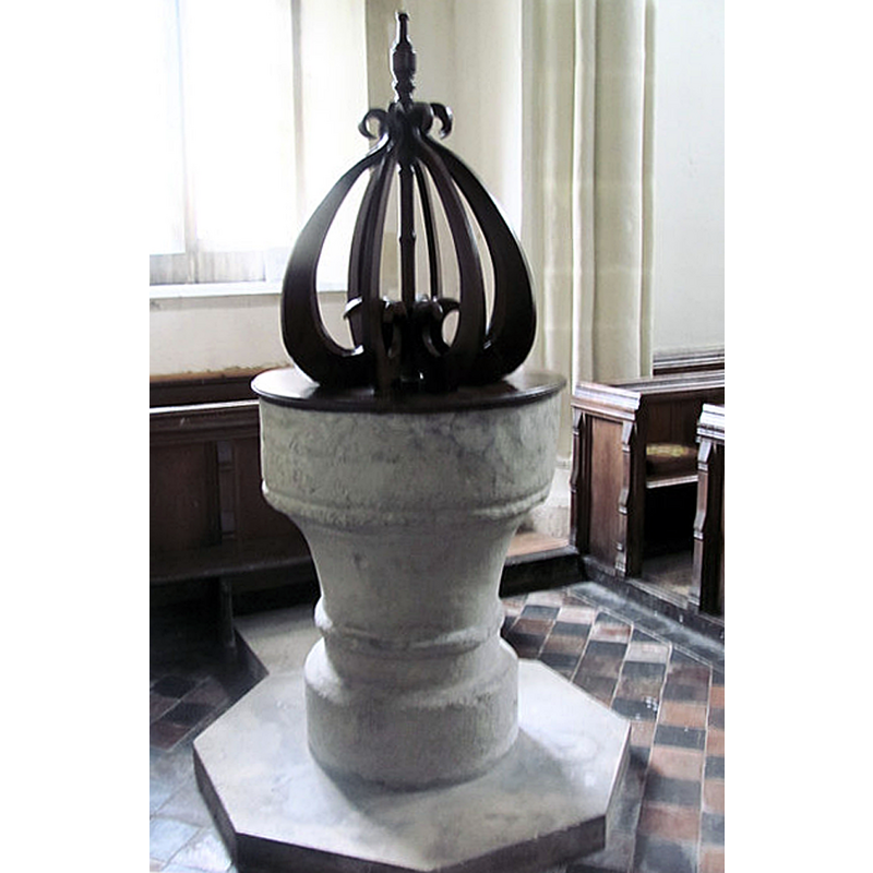
Image copyright © Chris Reynolds, 2012
CC-BY-SA-2.0
Results: 6 records
view of font and cover
Scene Description: Source caption: "The Font, St Mary the Virgin, Mentmore. The font is believed to be 13th century, The lid follows the design of a Jacobean lid, using some of the original wood."
Copyright Statement: Image copyright © Chris Reynolds, 2012
Image Source: digital photograph taken 30 March 2012 by Chris Reynolds [www.geograph.org.uk/photo/2874011] [accessed 20 November 2015]
Copyright Instructions: CC-BY-SA-2.0
design element - motifs - roll moulding
Copyright Statement: Image copyright © Chris Reynolds, 2012
Image Source: digital photograph taken 30 March 2012 by Chris Reynolds [www.geograph.org.uk/photo/2874011] [accessed 20 November 2015]
Copyright Instructions: CC-BY-SA-2.0
view of church exterior - southwest view
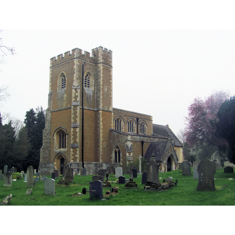
Scene Description: Source caption: "This church was originally in the centre of the village of Mentmore and surviving details date back to the early 13th century. Over the centuries other changes were made until the mid-Victorian period. Then Baron Mayer de Rothschild purchased the Manor of Mentmore, and relocated the village away from the church so he could build his magnificent house, Mentmore Towers, on the site of the village. The church underwent a major restoration and partial rebuild in 1858, carried out by George Stokes."
Copyright Statement: Image copyright © Chris Reynolds, 2012
Image Source: digital photograph taken 30 March 2012 by Chris Reynolds [www.geograph.org.uk/photo/2873939] [accessed 20 November 2015]
Copyright Instructions: CC-BY-SA-2.0
view of church interior - nave - looking west
![Source caption: "The Nave, St Mary the Virgin, Mentmore. In 1490 the Nave arcades were rebuilt, with the old pillars being reused. The Hatchment [...] is Victorian. The mezzanine floor in the Tower is modern."](/static-50478a99ec6f36a15d6234548c59f63da52304e5/compressed/1151121022_compressed.png)
Scene Description: Source caption: "The Nave, St Mary the Virgin, Mentmore. In 1490 the Nave arcades were rebuilt, with the old pillars being reused. The Hatchment [...] is Victorian. The mezzanine floor in the Tower is modern."
Copyright Statement: Image copyright © Chris Reynolds, 2012
Image Source: digital photograph taken 30 March 2012 by Chris Reynolds [www.geograph.org.uk/photo/2874034] [accessed 20 November 2015]
Copyright Instructions: CC-BY-SA-2.0
view of church interior - nave - looking east
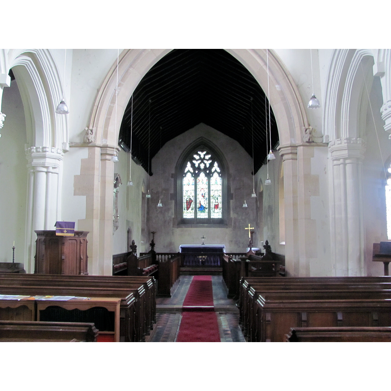
Scene Description: Source caption: "Looking towards the Chancel, St Mary the Virgin, Mentmore. The pulpit dates from the time of James 1st. The Chancel is a rebuild in 1858 of an earlier Chancel."
Copyright Statement: Image copyright © Chris Reynolds, 2012
Image Source: digital photograph taken 30 March 2012 by Chris Reynolds [www.geograph.org.uk/photo/2873990] [accessed 20 November 2015]
Copyright Instructions: CC-BY-SA-2.0
design element - motifs - roll moulding
Copyright Statement: Image copyright © Chris Reynolds, 2012
Image Source: digital photograph taken 30 March 2012 by Chris Reynolds [www.geograph.org.uk/photo/2874011] [accessed 20 November 2015]
Copyright Instructions: CC-BY-SA-2.0
INFORMATION
Font ID: 14451MEN
Object Type: Baptismal Font1
Font Century and Period/Style: 13th century, Early English
Church / Chapel Name: Parish Church of St. Mary the Virgin
Font Location in Church: Inside the church, in the tower [cf. FontNotes]
Church Patron Saint(s): St. Mary the Virgin
Church Address: Mentmore, Buckinghamshire LU7 0QQ
Site Location: Buckinghamshire, South East, England, United Kingdom
Directions to Site: Located off (W) the B488, 6 km SW of Leighton Buzzard, 13 km NE of Aylesbury
Ecclesiastic Region: Diocese of Oxford
Historical Region: Hundred of Cottesloe [in Domesday]
Additional Comments: disused font? (reported disused in 1925) -- disappeared font? (the one from the 12thC church here)
Font Notes:
Click to view
There is an entry for Mentmore [variant spelling] in the Domesday survey [http://opendomesday.org/place/SP9019/mentmore/] [accessed 20 November 2015], but it mentions neither cleric nor church in it. Described in Parker (1850): "Font circular, has a stem and base, with annular moulding." Sheahan (1862) notes: "the font is new and of Caen stone". The Victoria County History (Buckingham, vol. 3, 1925) notes: "A church probably consisting of a chancel and nave existed here in the 12th century. The aisles which were added to the nave in the 13th century were apparently rebuilt at the close of the 14th century, the south aisle being a few years later than the north. At the end of the 15th century the nave arcades were rebuilt [...] while at the same time the present tower was constructed. In 1858 the whole building was completely restored [...] There are two fonts, one modern and the other, probably of 13th-century date, now in the tower and disused, with a circular bowl and a tapering pedestal." The font cover is a rather stylised version of the Jacobean design of scroll ribs around a centre pivot; said to have been recunstructed using some wood from the original cover.
COORDINATES
UTM: 30U 659044 5748944
Latitude & Longitude (Decimal): 51.868578, -0.689897
Latitude & Longitude (DMS): 51° 52′ 6.88″ N, 0° 41′ 23.63″ W
MEDIUM AND MEASUREMENTS
Material: stone
Font Shape: cylindrical, mounted
Basin Interior Shape: round
Basin Exterior Shape: round
LID INFORMATION
Material: wood, oak
Apparatus: no
Notes: [cf. FontNotes]
REFERENCES
- Victoria County History [online], University of London, 1993-. URL: https://www.british-history.ac.uk.
- Parker, John Henry, The Ecclesiastical and architectural topography of England: Oxfordshire, Oxford, London: Published under the sanction of the Central Commitee of the Archaeological Institute of Great Britain and Ireland [by] John Henry Parker, 1850, [entry no.] 83
- Sheahan, James Joseph, History and topography of Buckinghamshire, comprising a general survey of the county, preceded by an epitome of the early history of Great Britain, London; Pontefract: Longman, Green, Longman, and Roberts; William Edward Bonas [...], 1862, p. 718