Shirburn / Sureburne
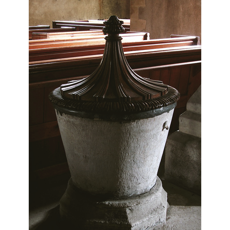
Image copyright © John Ward, 2007
Standing permission
Results: 4 records
view of font and cover
Copyright Statement: Image copyright © John Ward, 2007
Image Source: digital photograph taken 23 April 2007 by John Ward
Copyright Instructions: Standing permission
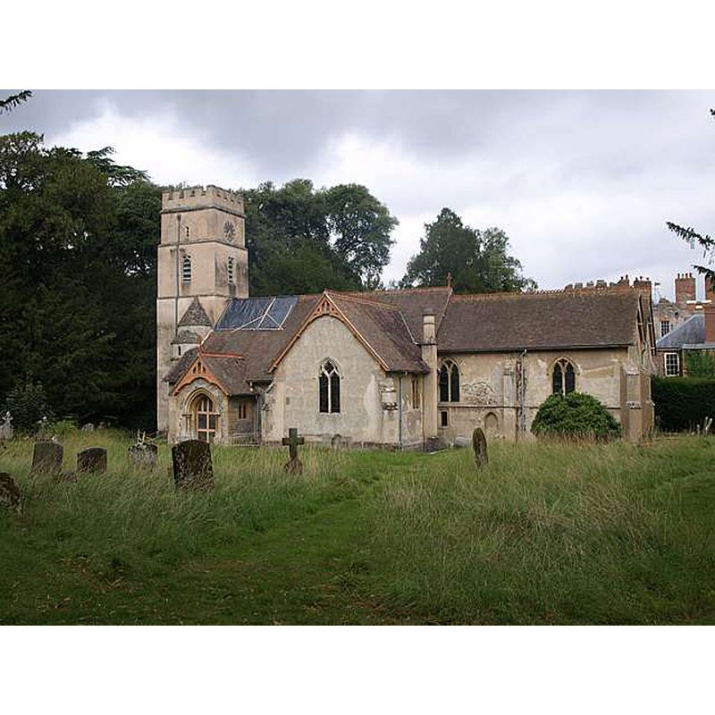
view of church exterior - tower - west side - detail
![Source caption: "Cletic [sic] knotwork tympanum at the ewest side of the tower" [NB: the CRSBI entry [www.crsbi.ac.uk/site/749/] [accessed 1 November 2017] has: "The tympanum is reused as an external lintel over the late medieval window in the ground stage of the W wall of the tower. It is covered with three-strand figure-of-eight knot pattern, bordered by a roll-moulding and by a band of guilloche with the fields enclosing small stars."](/static-50478a99ec6f36a15d6234548c59f63da52304e5/compressed/1171101018_compressed.png)
Scene Description: Source caption: "Cletic [sic] knotwork tympanum at the ewest side of the tower" [NB: the CRSBI entry [www.crsbi.ac.uk/site/749/] [accessed 1 November 2017] has: "The tympanum is reused as an external lintel over the late medieval window in the ground stage of the W wall of the tower. It is covered with three-strand figure-of-eight knot pattern, bordered by a roll-moulding and by a band of guilloche with the fields enclosing small stars."
Copyright Statement: Image copyright © Abaroth, 2017
Image Source: digital photograph by Abaroth [http://abarothsworld.com/Places/Shirburn Church.htm#nogo] [accessed 1 November 2017]
Copyright Instructions: "Permission is given to reproduce for non-profit purposes only"
view of church exterior - southeast view
Copyright Statement: Image copyright © Abaroth, 2017
Image Source: digital photograph by Abaroth [http://abarothsworld.com/Places/Shirburn Church.htm#nogo] [accessed 1 November 2017]
Copyright Instructions: "Permission is given to reproduce for non-profit purposes only"
view of font and cover in context
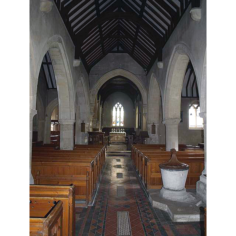
Scene Description: in the nave, looking east
Copyright Statement: Image copyright © Abaroth, 2017
Image Source: digital photograph by Abaroth [http://abarothsworld.com/Places/Shirburn Church.htm#nogo] [accessed 1 November 2017]
Copyright Instructions: "Permission is given to reproduce for non-profit purposes only"
INFORMATION
Font ID: 14346SHI
Object Type: Baptismal Font1
Font Century and Period/Style: 13th century, Early English
Church / Chapel Name: Parish Church of All Saints [redundant]
Font Location in Church: Inside the church
Church Patron Saint(s): All Saints
Church Notes: redundant church in the care of the Churches Conservation Trust
Church Address: Castle Road, Oxford, Oxfordshire, OX49 5DL, UK
Site Location: Oxfordshire, South East, England, United Kingdom
Directions to Site: Located off the B4009, 4 km SW of Lewknor
Ecclesiastic Region: Diocese of Oxford
Historical Region: Hundred of Pyrton
Additional Comments: disappeared font? (the one from the mid-12thC church here)
Font Notes:
Click to view
There are two entries for Shirburn [variant spelling] in the Domesday survey [http://opendomesday.org/place/SU6995/shirburn/] [accessed 1 November 2017], neither of which mentions priest or church in it. The Victoria County History (Oxford, vol. 8, 1964) notes: "Between 1146 and 1163 Roger Fitz Alfred, apparently the tenant of the D'Oilly manor, seems to have given the church to Dorchester Abbey [...] The tub font is medieval and has a Georgian pyramidal cover of carved oak." Noted in Sherwood & Pevsner (1974): "Font. Plain, C13?, with a Georgian cover."
Credit and Acknowledgements: We are grateful to John Ward, of Oxfordshire Churches [http://homepage.mac.com/john.ward/oxfordshirechurches], for his photograph of this font
COORDINATES
UTM: 30U 638713 5724872
Latitude & Longitude (Decimal): 51.6577, -0.9946
Latitude & Longitude (DMS): 51° 39′ 27.72″ N, 0° 59′ 40.56″ W
MEDIUM AND MEASUREMENTS
Material: stone, limestone?
Font Shape: bucket-shaped, mounted
Basin Interior Shape: round
Basin Exterior Shape: round
Drainage System: centre hole in basin
Drainage Notes: lead-lined
LID INFORMATION
Date: 18th-century? / Georgian?
Material: wood, oak
Apparatus: no
Notes: [cf. FontNotes]
REFERENCES
- Victoria County History [online], University of London, 1993-. URL: https://www.british-history.ac.uk.
- Pevsner, Nikolaus, Oxfordshire, Harmondsworth: Penguin Books, 1974, p. 761