Slapton nr. Dartmouth / Sladone
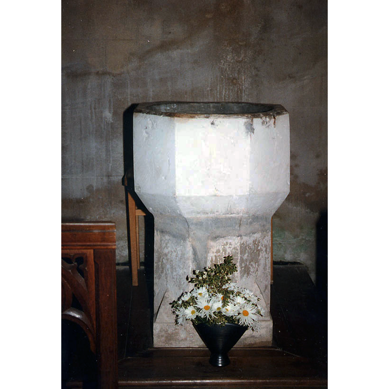
Image copyright © John Salmon, 2010
CC-BY-SA-2.0
Results: 4 records
view of font
Copyright Statement: Image copyright © John Salmon, 2010
Image Source: photograph taken August 1996 by John Salmon [www.geograph.org.uk/photo/1738222] [accessed 23 November 2015]
Copyright Instructions: CC-BY-SA-2.0
view of church exterior - northeast view
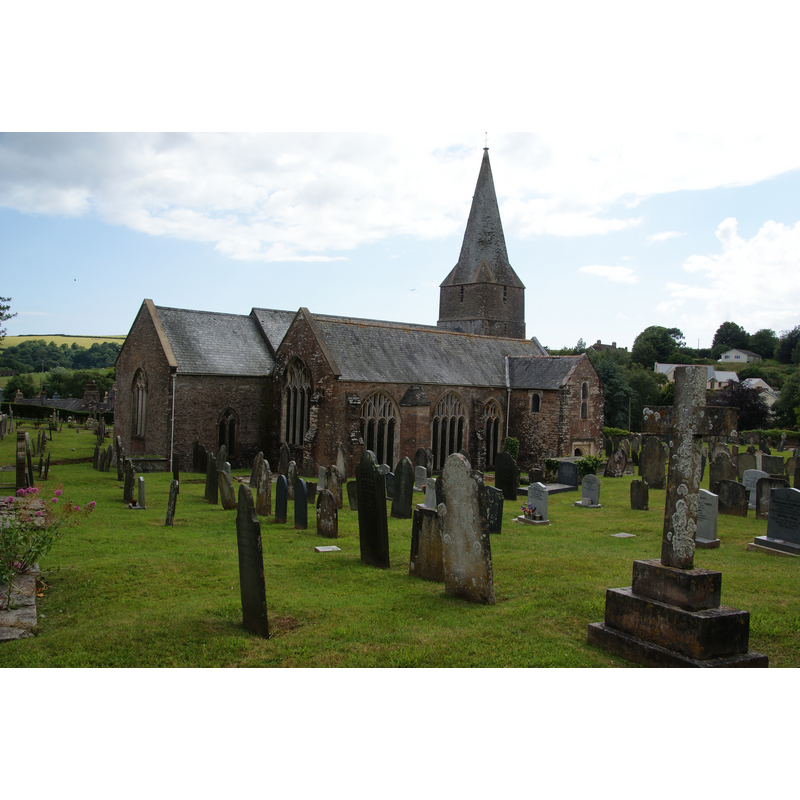
Copyright Statement: Image copyright © Bil Boaden, 2011
Image Source: digital photograph taken 23 June 2011 by Bill Boaden [ww.geograph.org.uk/photo/2505696] [accessed 23 November 2015]
Copyright Instructions: CC-BY-SA-2.0
view of church exterior - southeast view
![Source caption: "Church of St James. Begun in the late 13th or early 14th C. the church has additionions in each successive century before being 'restored' in 1905."
EXT NE digital photograph taken 23 June 2011 by Bill Boaden [ww.geograph.org.uk/photo/2505696] [accessed 23 November 2015]
INT photograph taken August 1996 by John Salmon [www.geograph.org.uk/photo/1738219] [accessed 23 November 2015] Copyright 2010
FONT photograph taken August 1996 by John Salmon [www.geograph.org.uk/photo/1738222] [accessed 23 November 2015] Copyright 2010](/static-50478a99ec6f36a15d6234548c59f63da52304e5/compressed/1151125002_compressed.png)
Scene Description: Source caption: "Church of St James. Begun in the late 13th or early 14th C. the church has additionions in each successive century before being 'restored' in 1905."
EXT NE digital photograph taken 23 June 2011 by Bill Boaden [ww.geograph.org.uk/photo/2505696] [accessed 23 November 2015]
INT photograph taken August 1996 by John Salmon [www.geograph.org.uk/photo/1738219] [accessed 23 November 2015] Copyright 2010
FONT photograph taken August 1996 by John Salmon [www.geograph.org.uk/photo/1738222] [accessed 23 November 2015] Copyright 2010
Copyright Statement: Image copyright © Stuart Logan, 2013
Image Source: digital photograph taken 4 October 2013 by Stuart Logan [www.geograph.org.uk/photo/3889332] [accessed 23 November 2015]
Copyright Instructions: CC-BY-SA-2.0
view of church interior - nave - looking east
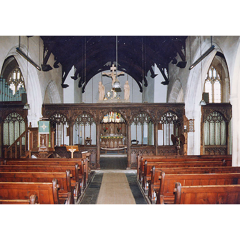
Copyright Statement: Image copyright © John Salmon, 2010
Image Source: photograph taken August 1996 by John Salmon [www.geograph.org.uk/photo/1738219] [accessed 23 November 2015]
Copyright Instructions: CC-BY-SA-2.0
INFORMATION
Font ID: 14322SLA
Object Type: Baptismal Font1
Font Date: ca. 1370?
Font Century and Period/Style: 14th century, Decorated
Church / Chapel Name: Parish Church of St. James the Great
Font Location in Church: Inside the church
Church Patron Saint(s): St. James the Greater [aka James the Great, James the Elder]
Church Address: 2 Brook Street, Slapton, Devon TQ7 2PW
Site Location: Devon, South West, England, United Kingdom
Directions to Site: Located on the A379, 12 km SW of Dartmouth
Ecclesiastic Region: Diocese of Exeter
Historical Region: Hundred of Chillington [in Domesday]
Additional Comments: altered font? [cf. FontNotes]
Font Notes:
Click to view
There is an entry for this Slapton [variant spelling] in the Domesday survey [http://opendomesday.org/place/SX8244/slapton/] [accessed 23 November 2015], but it mentions neither cleric nor church in it. Oliver (1841) reports a collegiate church founded at Slapton ca. 1370. English Heritage [Listing NGR: SX8213244989] (1967) cites: "Davidson states (1842) that the old font "recently reduced in size"." The font, at present, consists of an octagonal basin with plain re-tooled sides and a chamfered underbowl, also plain; raised on an octagonal pedestal base with broach stops that make it square at the bottom; the innner basin is lead-lined.
COORDINATES
UTM: 30U 453245 5571451
Latitude & Longitude (Decimal): 50.293324, -3.656403
Latitude & Longitude (DMS): 50° 17′ 35.96″ N, 3° 39′ 23.05″ W
MEDIUM AND MEASUREMENTS
Material: stone
Font Shape: octagonal, mounted
Basin Interior Shape: round
Basin Exterior Shape: octagonal
Drainage Notes: lead-lined
LID INFORMATION
Date: 18th century?
Material: wood, oak
REFERENCES
- Oliver, George, Historic collections relating to the monasteries of Devon, Exeter: P. A. Hannaford, 1841, p. 130