Pishill
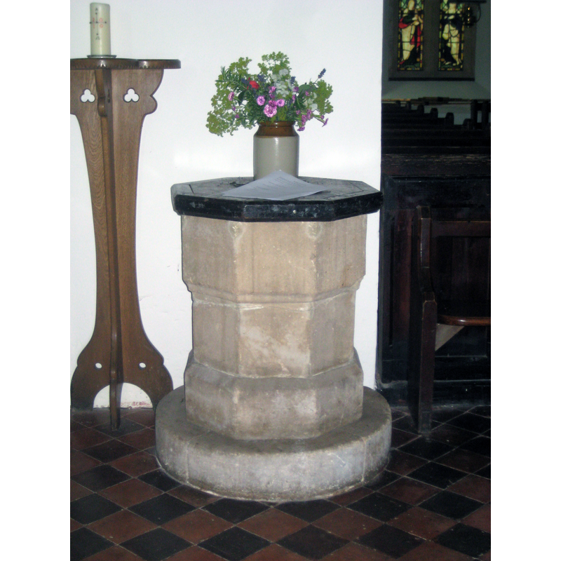
Image copyright © Norfolk12, 2010
No known copyright restriction / Fair Dealing
Results: 2 records
view of font and cover
Copyright Statement: Image copyright © Norfolk12, 2010
Image Source: digital photograph 14 July 2010 by Norfolk12 [www.waymarking.com/waymarks/WM98MB_Font_The_Parish_Church_Pishill_Oxon] [accessed 1 November 2017]
Copyright Instructions: No known copyright restriction / Fair Dealing
view of church exterior - southwest view
![Source caption: "The church, Pishill. A [N]orman and late 13th century church, largely rebuilt in 1854."](/static-50478a99ec6f36a15d6234548c59f63da52304e5/compressed/1171101009_compressed.png)
Scene Description: Source caption: "The church, Pishill. A [N]orman and late 13th century church, largely rebuilt in 1854."
Copyright Statement: Image copyright © Andrew Smith, 2008
Image Source: digital photograph taken 30 March 2008 by Andrew Smith [www.geograph.org.uk/photo/755087] [accessed 1 November 2017]
Copyright Instructions: CC-BY-SA-2.0
INFORMATION
Font ID: 14318PIS
Object Type: Baptismal Font1
Font Century and Period/Style: 14th century [re-cycled], Decorated [altered]
Church / Chapel Name: Parish Church
Font Location in Church: Inside the church
Church Address: Church Hill, Pishill, Oxfordshire, RG9 6HJ, UK
Site Location: Oxfordshire, South East, England, United Kingdom
Directions to Site: Located off (S) the B480, SE of Watlington, 8 km N of Henley-on-Thames, SE of Oxford
Ecclesiastic Region: Diocese of Oxford
Historical Region: Hundred of Pyrton
Additional Comments: re-cycled column? (present font) -- disappeared font? (the one from the mid-12thC church here)
Font Notes:
Click to view
No entry found for Pishill in the Domesday survey. The Victoria County History (Oxford, vol. 8, 1964) informs: "Pishill church was first mentioned in a papal confirmation of a grant to Dorchester Abbey, made between 1146 and 1163, by Stephen of Pishill, the lord of Pishill Napper manor [...] If, as seems likely, Pishill Napper was once in the parish of Watlington [...] the creation of the parish of Pishill and the building of its church must surely have taken place before 1129 when Oseney was founded", but does not mention a font. Sherwood & Pevsner (1974) write: "Font. Probably part of a C14 octagonal pier re-used." The entry for this church in British Listed Buildings [Listing NGR: SU7263689849] reports: "C14 octagonal font with mid C19 cover. "
COORDINATES
UTM: 30U 641789 5718859
Latitude & Longitude (Decimal): 51.6029, -0.9526
Latitude & Longitude (DMS): 51° 36′ 10.44″ N, 0° 57′ 9.36″ W
MEDIUM AND MEASUREMENTS
Material: stone
Font Shape: octagonal, mounted
Basin Interior Shape: round
Basin Exterior Shape: octagonal
LID INFORMATION
Material: wood, oak?
Apparatus: no
Notes: octagonal, flat and plain
REFERENCES
- Victoria County History [online], University of London, 1993-. URL: https://www.british-history.ac.uk.
- Pevsner, Nikolaus, Oxfordshire, Harmondsworth: Penguin Books, 1974, p. 732