Ardley / Ardulueslie
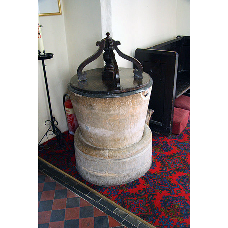
Image copyright © Richard Croft, 2010
CC-BY-SA-2.0
Results: 4 records
view of font and cover
Copyright Statement: Image copyright © Richard Croft, 2010
Image Source: digital photograph taken 27 July 2010 by Richard Croft [www.geograph.org.uk/photo/1997246] [accessed 5 December 2016]
Copyright Instructions: CC-BY-SA-2.0
view of font and cover
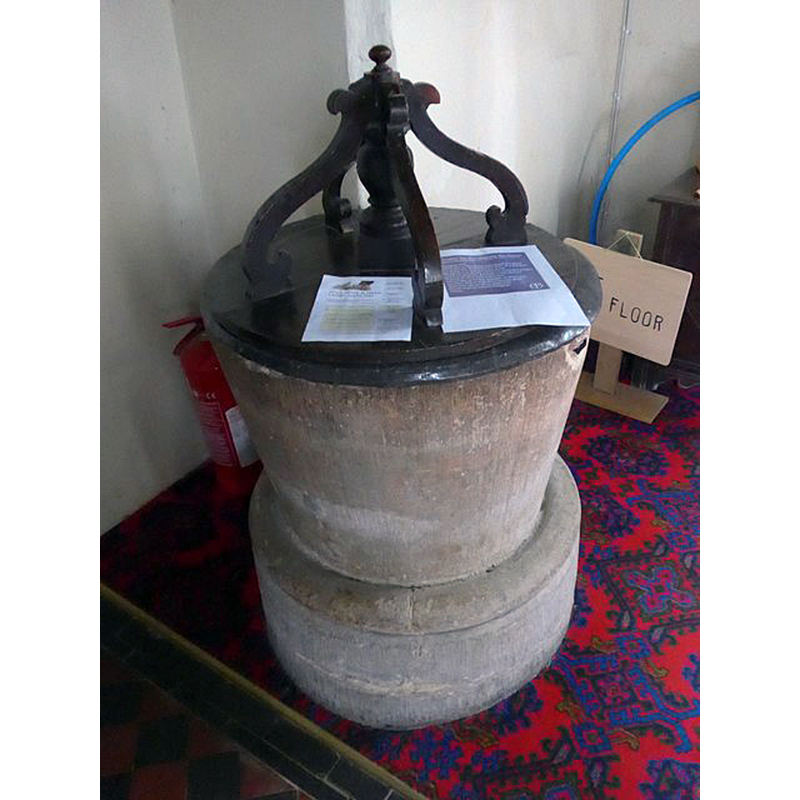
Copyright Statement: Image copyright © Basher Eyre, 2015
Image Source: digital photograph taken 21 September 2015 by Basher Eyre [www.geograph.org.uk/photo/4787623] [accessed 5 December 2016]
Copyright Instructions: CC-BY-SA-2.0
view of church exterior - south view
![EXT digital photograph taken 23 January 2006 by Colin Bates [www.geograph.org.uk/photo/114065] [accessed 5 December 2016]
INT W digital photograph taken 21 September 2015 by Basher Eyre [www.geograph.org.uk/photo/4787618] [accessed 5 December 2016]
FONT digital photograph taken 21 September 2015 by Basher Eyre [www.geograph.org.uk/photo/4787623] [accessed 5 December 2016]
FONT_COVER digital photograph taken 27 July 2010 by Richard Croft [www.geograph.org.uk/photo/1997246] [accessed 5 December 2016]](/static-50478a99ec6f36a15d6234548c59f63da52304e5/compressed/1161206007_compressed.png)
Scene Description: EXT digital photograph taken 23 January 2006 by Colin Bates [www.geograph.org.uk/photo/114065] [accessed 5 December 2016]
INT W digital photograph taken 21 September 2015 by Basher Eyre [www.geograph.org.uk/photo/4787618] [accessed 5 December 2016]
FONT digital photograph taken 21 September 2015 by Basher Eyre [www.geograph.org.uk/photo/4787623] [accessed 5 December 2016]
FONT_COVER digital photograph taken 27 July 2010 by Richard Croft [www.geograph.org.uk/photo/1997246] [accessed 5 December 2016]
Copyright Statement: Image copyright © Colin Bates, 2006
Image Source: digital photograph taken 23 January 2006 by Colin Bates [www.geograph.org.uk/photo/114065] [accessed 5 December 2016]
Copyright Instructions: CC-BY-SA-2.0
view of church interior - nave - looking west
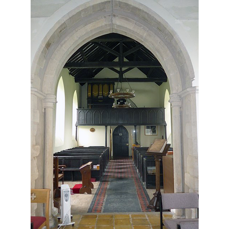
Copyright Statement: Image copyright © Basher Eyre, 2015
Image Source: digital photograph taken 21 September 2015 by Basher Eyre [www.geograph.org.uk/photo/4787618] [accessed 5 December 2016]
Copyright Instructions: CC-BY-SA-2.0
INFORMATION
Font ID: 14199ARD
Object Type: Baptismal Font1
Font Century and Period/Style: 13th century, Early English
Church / Chapel Name: Parish Church of St. Mary
Font Location in Church: Inside the church, at the W end of the nave, N side of the doorway
Church Patron Saint(s): St. Mary the Virgin
Church Address: B430 [Somerton Road], Ardley, Oxfordshire OX6 9NS, UK
Site Location: Oxfordshire, South East, England, United Kingdom
Directions to Site: Located on the B4030, just W of the M40, 6-7 km NNW of Bicester
Ecclesiastic Region: Diocese of Oxford
Historical Region: Hundred of Kirtlington [in Domesday] -- Hundred of Ploughley
Additional Comments: disappeared font? (the one from the ca. 1074 church here)
Font Notes:
Click to view
There is an entry for Ardley [variant spelling] in the Domesday survey [http://opendomesday.org/place/SP5427/ardley/] [accessed 5 December 2016], but it mentions neither cleric nor church in it. The Victoria County History (Oxford, vol. 6, 1959) notes: "There was a church in Ardley by 1074 [...] largely rebuilt at the end of the 18th century [...] The circular font is probably 13th century". The VCH makes reference to a drawing of this font, by Buckler [ca. 1823?] in MS. Top. Oxon. b 220. a 65, f. 43 [in the Bodleian Library]. Not mentioned in Sherwood & Pevsner (1974).
COORDINATES
UTM: 30U 622837 5756048
Latitude & Longitude (Decimal): 51.94157, -1.212946
Latitude & Longitude (DMS): 51° 56′ 29.65″ N, 1° 12′ 46.61″ W
MEDIUM AND MEASUREMENTS
Material: stone
Font Shape: bucket-shaped, mounted
Basin Interior Shape: round
Basin Exterior Shape: round
LID INFORMATION
Material: wood, oak?
Apparatus: no
Notes: round flat platform with four vertical scroll ribs around a turned pivot
REFERENCES
- Victoria County History [online], University of London, 1993-. URL: https://www.british-history.ac.uk.