Bream / Breem
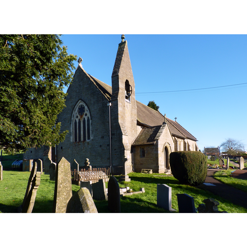
Image copyright © Ruth Sharville, 2014
CC-BY-SA-2.0
Results: 2 records
view of church exterior - southwest view
Scene Description: the 19thC re-building of Bream St James'
Copyright Statement: Image copyright © Ruth Sharville, 2014
Image Source: digital photograph taken 11 January 2014 by Ruth Sharville [www.geograph.org.uk/photo/3810073] [accessed 12 December 2018]
Copyright Instructions: CC-BY-SA-2.0
view of font and cover in context
![[NB: although the entry for this church in the VCH notes the 1824 re-building of a chapel at Bream, in which "The font has an octagonal bowl on a slender pillar and apparently dates from the 17th century", this font looks modern].](/static-50478a99ec6f36a15d6234548c59f63da52304e5/compressed/1181216009_compressed.png)
Scene Description: [NB: although the entry for this church in the VCH notes the 1824 re-building of a chapel at Bream, in which "The font has an octagonal bowl on a slender pillar and apparently dates from the 17th century", this font looks modern].
Copyright Statement: Image copyright © Bream Parish Church, 2014
Image Source: digital photograph tane 5 October 2014, in Bream Church [www.breamchurch.org.uk] [accessed 12 December 2018]
Copyright Instructions: No known copyright restriction / Fair Dealing
INFORMATION
Font ID: 14099BRE
Object Type: Baptismal Font1
Font Century and Period/Style: 17th century, Restoration
Church / Chapel Name: Parish Church of St. James
Church Patron Saint(s): St. James
Church Address: Coleford Rd, Bream, Lydney GL15 6ES, UK -- Tel.: +44 1594 562985
Site Location: Gloucestershire, South West, England, United Kingdom
Directions to Site: Located off (N) the B4231, 10 km NW of Berkeley
Ecclesiastic Region: Diocese of Gloucester
Historical Region: Hundred of Bledsloe and Hundred of St. Briavels
Additional Comments: disappeared font? (the one from the 15thC(?) church here)
Font Notes:
Click to view
No individual entry found for Bream / Breem in the Domesday survey. A manuscript written by the Revd' Ernest Eales in 1902 [https://web.archive.org/web/20100901234646/http://www.breamvillage.co.uk/4.html#] [accessed 12 December 2018] notes: "The Piscina in the North wall of the Chancel is pre-reformation (15th century). In 1618 The ancient chapel of St. James, Bream, was apparently in the hands of the Crown before this date, and was by letters patent of 16 James 1viz. June 30th 1618". The entry for the parish of Newland in the Victoria County History (Gloucester, vol. 5, 1996) notes the 1824 re-building of a chapel at Bream, in which "The font has an octagonal bowl on a slender pillar and apparently dates from the 17th century."
COORDINATES
UTM: 30U 529012 5732947
Latitude & Longitude (Decimal): 51.74668, -2.57977
Latitude & Longitude (DMS): 51° 44′ 48.05″ N, 2° 34′ 47.17″ W
REFERENCES
- Victoria County History [online], University of London, 1993-. URL: https://www.british-history.ac.uk.