Shipton Sollars / Scipetune / Shipton Solers / Shipton Sollers
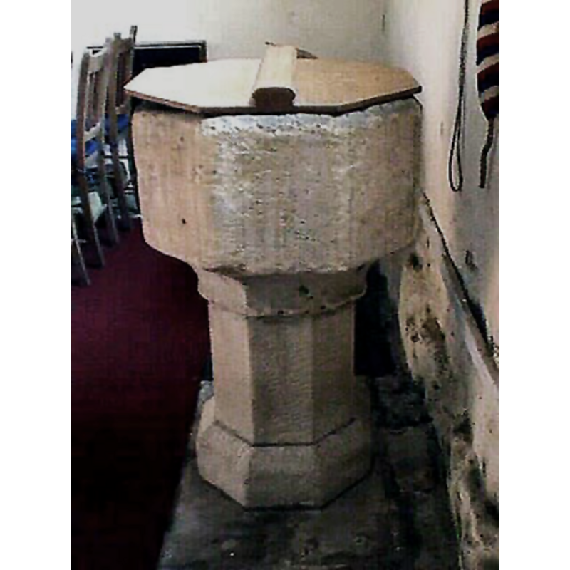
Image copyright © John Wilkes, 2008
Standing permission
Results: 6 records
view of font and cover
Copyright Statement: Image copyright © John Wilkes, 2008
Image Source: digital photograph by John Wilkes [www.allthecotswolds.com]
Copyright Instructions: Standing permission
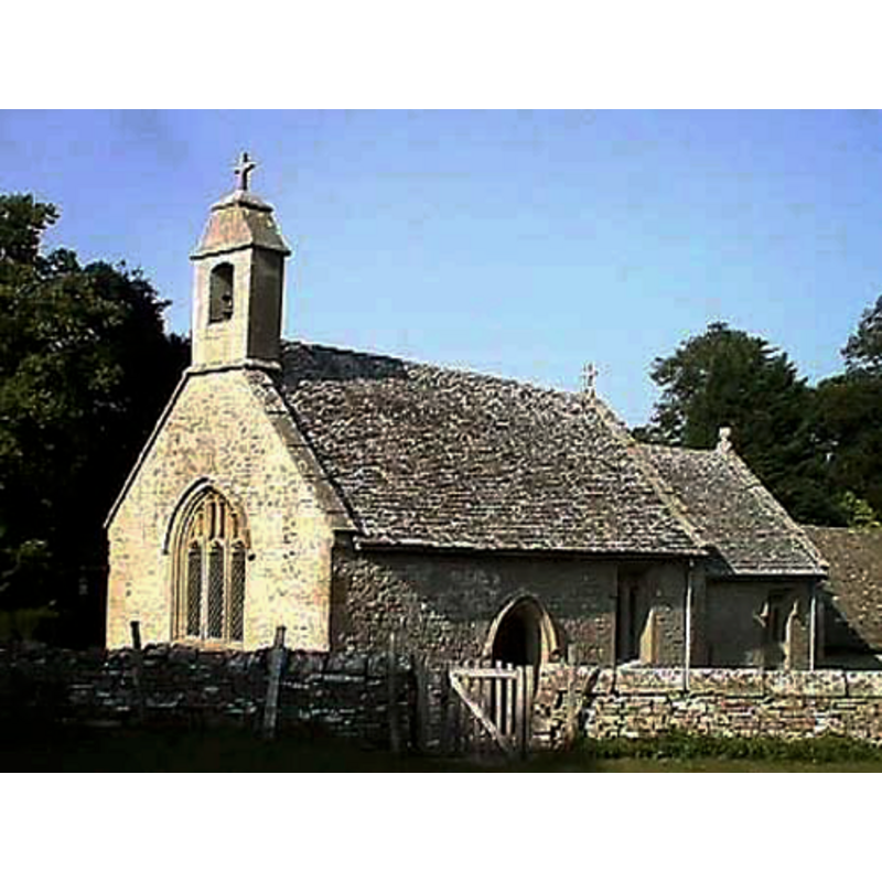
view of church exterior - southeast view

Scene Description: Source caption: "Shipton Solers (or Sollars) church is dedicated to St Mary. The church dates from the 13th century which has been restored a couple of times, in 1884-5 for Mr. E. Fieldhouse of Shipton Sollars Manor and again in 1930 by Messrs. R.L. Boulton".
view of church exterior - southwest view
Copyright Statement: Image copyright © John Wilkes, 2008
Image Source: digital photograph by John Wilkes [www.allthecotswolds.com]
Copyright Instructions: Standing permission
view of church interior - nave - north wall - painting
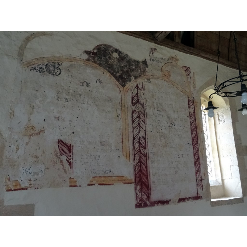
Copyright Statement: Image copyright © Philip Halling, 2018
Image Source: digital photograph taken 28 July 2018 by Philip Halling [www.geograph.org.uk/photo/5863228] [accessed 7 February 2019]
Copyright Instructions: CC-BY-SA-2.0
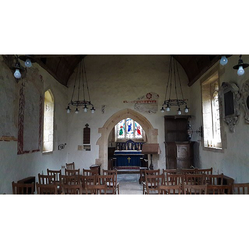
view of church interior - looking west
![the font is visible at the far [west] end, beneath the window](/static-50478a99ec6f36a15d6234548c59f63da52304e5/compressed/1190207012_compressed.png)
Scene Description: the font is visible at the far [west] end, beneath the window
Copyright Statement: Image copyright © Chris Brown, 2017
Image Source: digital photograph taken 23 December 2017 by Chris Brown [www.geograph.org.uk/photo/5661982] [accessed 7 February 2019]
Copyright Instructions: CC-BY-SA-2.0
view of church interior - nave - looking east
Copyright Statement: Image copyright © Chris Brown, 2017
Image Source: digital photograph taken 23 December 2017 by Chris Brown [www.geograph.org.uk/photo/5633906] [accessed 7 February 2019]
Copyright Instructions: CC-BY-SA-2.0
INFORMATION
Font ID: 14071SHI
Object Type: Baptismal Font1
Font Century and Period/Style: 15th century, Perpendicular
Church / Chapel Name: Parish Church of St. Mary [redundant]
Font Location in Church: Inside the church [cf. FontNotes]
Church Patron Saint(s): St. Mary the Virgin
Church Notes: "The church continued in occasional use during the 20th century, but was declared redundant in 2005, and vested in the Churches Conservation Trust on 15 July of that year." [http://en.wikipedia.org/wiki/St_Mary%27s_Church,_Shipton_Solars] [accessed 25 July 2012]
Church Address: Shipton Sollars, Gloucestershire GL54 4HU, UK
Site Location: Gloucestershire, South West, England, United Kingdom
Directions to Site: Located off (NE) the A40-A436 crossroads
Ecclesiastic Region: Diocese of Gloucester
Historical Region: Hundred of Bradley -- Hundred of Wacrescumbe [in Domesday]
Additional Comments: disappeared font? (the one from the ca. 1236 church here)
Font Notes:
Click to view
There is an entry for Shipton [Solers] [variant spelling] in the Domesday survey [https://opendomesday.org/place/SP0318/shipton-solers/] [accessed 7 February 2019] but it mentions neither cleric nor church in it. Verey & Brooks (1999-2002) note: "Font. C15. Unadorned octagonal bowl and base." The entry for the two parishes of Shipton Oliffe and Solers in the Victoria County History (Gloucester, vol. 9, 2001) notes: "Shipton Solers church [...] in 1236 was a chapel dedicated to St. Mary [...] The 15th-century font has a plain octagonal bowl on an octagonal stem", text footnoted: "According to Bigland, Glos. iii, no. 234, the Shipton Solers font was removed to Shipton Oliffe ch. in the mid 19th cent." The Churches Conservation Trust [www.visitchurches.org.uk/content.php?nID=11&churchID=253] [accessed 4 December 2008] reports a 15th-century font in this church. The font consists of an octagonal basin with plain vertical sides and a plain concave underbowl; it is very worn, and all it appears to be all in one piece down to the 'neck' below the underbowl; it is raised on a plain octagonal stem and lower base, both of which might be a later addition [unless they were not as exposed to the elements as the basin must have been for a long period of time]. Plain wooden cover, octagonal and flat; modern.
Credit and Acknowledgements: We are grateful to John Wilkes, of www.allthecotswolds.com, for his photographs of church and font
COORDINATES
UTM: 30U 571886 5746527
Latitude & Longitude (Decimal): 51.8649, -1.956
Latitude & Longitude (DMS): 51° 51′ 53.64″ N, 1° 57′ 21.6″ W
MEDIUM AND MEASUREMENTS
Material: stone
Font Shape: octagonal, mounted
Basin Interior Shape: round
Basin Exterior Shape: octagonal
REFERENCES
- Victoria County History [online], University of London, 1993-. URL: https://www.british-history.ac.uk.
- Verey, David, Gloucestershire, London: Penguin Books, 1999-2002, vol. 1: 608