Sapperton nr. Cirencester / Sapletorne
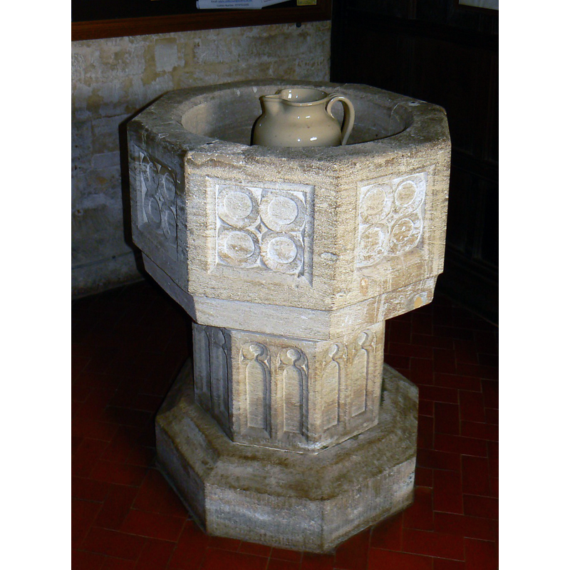
Image copyright © Brian Robert Marshall, 2011
CC-BY-SA-2.0
Results: 5 records
view of font
Scene Description: Source caption: "Font, Church of St Kenelm. The font is not as ornate as some and has no cover. It is about 500 years old and is clearly still in use."
Copyright Statement: Image copyright © Brian Robert Marshall, 2011
Image Source: edited detail of a digital photograph taken 17 February 2011 by Brian Robert Marshall [www.geograph.org.uk/photo/2274439] [accessed 15 February 2019]
Copyright Instructions: CC-BY-SA-2.0
design element - motifs - circle - 32
Scene Description: arranged two up, two down. on each panel, "not quite a quatrefoil" [cf. Font notes]
Copyright Statement: Image copyright © Brian Robert Marshall, 2011
Image Source: edited detail of a digital photograph taken 17 February 2011 by Brian Robert Marshall [www.geograph.org.uk/photo/2274439] [accessed 15 February 2019]
Copyright Instructions: CC-BY-SA-2.0
view of church exterior in context - southeast view
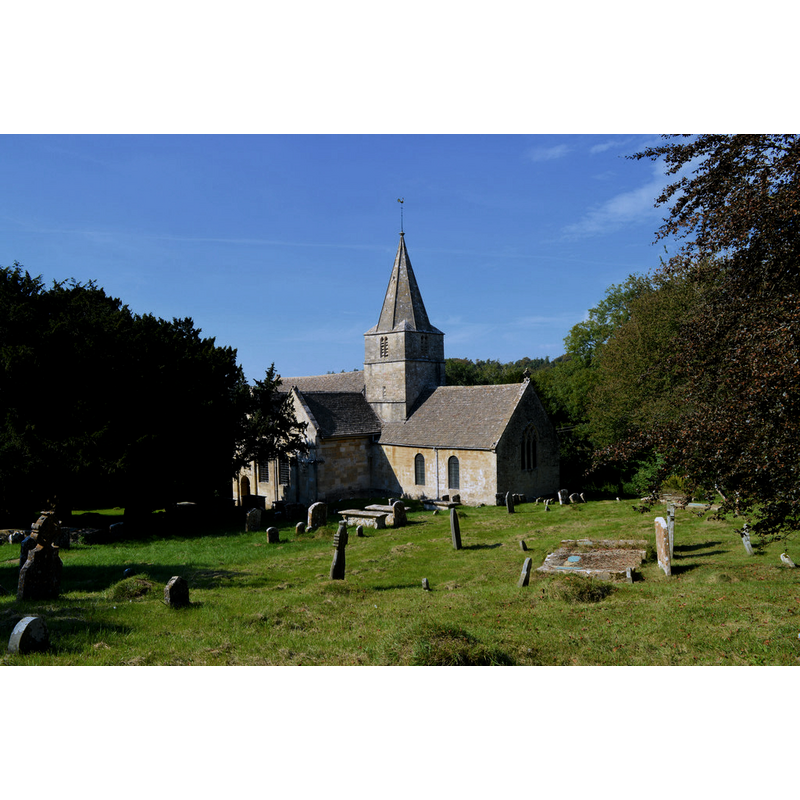
Scene Description: Source caption: "St Kenelm, Sapperton. Norman origins are hard to detect, but there is no missing the extravagant work of superb quality done in the early 18th century. The church contains wonderful woodwork and some superb monuments to long gone aristocrats. Leading exponents of the Arts and Crafts movement are also buried here."
Copyright Statement: Image copyright © Philip Pankhurst, 2014
Image Source: digital photograph taken 22 September 2014 by Philip Pankhurst [www.geograph.org.uk/photo/4182000] [accessed 15 February 2019]
Copyright Instructions: CC-BY-SA-2.0
view of church interior - nave - looking east
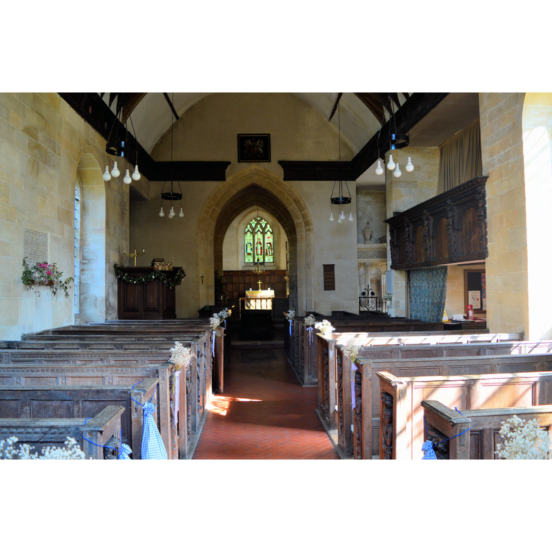
Copyright Statement: Image copyright © Philip Pankhurst, 2014
Image Source: digital photograph taken 22 September 2014 by Philip Pankhurst [www.geograph.org.uk/photo/4182000] [accessed 15 February 2019]
Copyright Instructions: CC-BY-SA-2.0
design element - architectural - arch or window - trefoiled - 16
Scene Description: [cf. Font notes]
Copyright Statement: Image copyright © Brian Robert Marshall, 2011
Image Source: edited detail of a digital photograph taken 17 February 2011 by Brian Robert Marshall [www.geograph.org.uk/photo/2274439] [accessed 15 February 2019]
Copyright Instructions: CC-BY-SA-2.0
INFORMATION
Font ID: 14068SAP
Object Type: Baptismal Font1
Font Century and Period/Style: 15th century, Perpendicular
Church / Chapel Name: Parish Church of St. Kenelm
Font Location in Church: Outside, in the S porch
Church Patron Saint(s): St. Kenelm [aka Cynehelm, Cynhelm, Kenelme]
Church Address: Church Ln, Sapperton, Cirencester GL7 6LQ, UK -- Tel.: +44 117 929 1766
Site Location: Gloucestershire, South West, England, United Kingdom
Directions to Site: Located off (N) the A479, 7 km W of Cirencester [NB: there are two Sappertones in Gloucs.; the other is nearer Cheltenham]
Ecclesiastic Region: Diocese of Gloucester
Historical Region: Hundred of Bisley
Additional Comments: disappeared font? (the one from the ca. 1190 church here)
Font Notes:
Click to view
There is an entry for this Sapperton [variant spelling] in the Domesday survey [http://opendomesday.org/place/TF0133/sapperton/] [accessed 18 June 2018], but it mentions neither priest nor church in it. The entry for this parish in the Victoria County History (Gloucester, vol. 11, 1976) notes: "The octagonal font was made in the 15th century". The VCH notes also that "There was a church at Sapperton by the 1190s when a priest was recorded there", but we have no information on the earlier font of that church. Noted in Verey & Brooks (1999-2002): "Font. C15, octagonal, each face of the bowl with four circles (i.e. not quite a quatrefoil), each face of the stem with paired trefoil-headed niches." The British Listed Building s database [www.britishlistedbuildings.co.uk/en-128360-church-of-st-kenelm-sapperton] [accessed 27 July 2012] gives the font location in the south porch.
Credit and Acknowledgements: We are grateful to John Wilkes, of www.allthecotswolds.com, for his photographs of church and font
COORDINATES
UTM: 30U 563710 5731340
Latitude & Longitude (Decimal): 51.729362, -2.077516
Latitude & Longitude (DMS): 51° 43′ 45.7″ N, 2° 4′ 39.06″ W
MEDIUM AND MEASUREMENTS
Material: stone
Font Shape: octagonal, mounted
Basin Interior Shape: round
Basin Exterior Shape: octagonal
REFERENCES
- Victoria County History [online], University of London, 1993-. URL: https://www.british-history.ac.uk.
- Verey, David, Gloucestershire, London: Penguin Books, 1999-2002, vol. 1: 587