York No. 20, Spurriergate / Eboracum / Eburacum / Eburākon / Eoforwic / Everwic / Jórvík
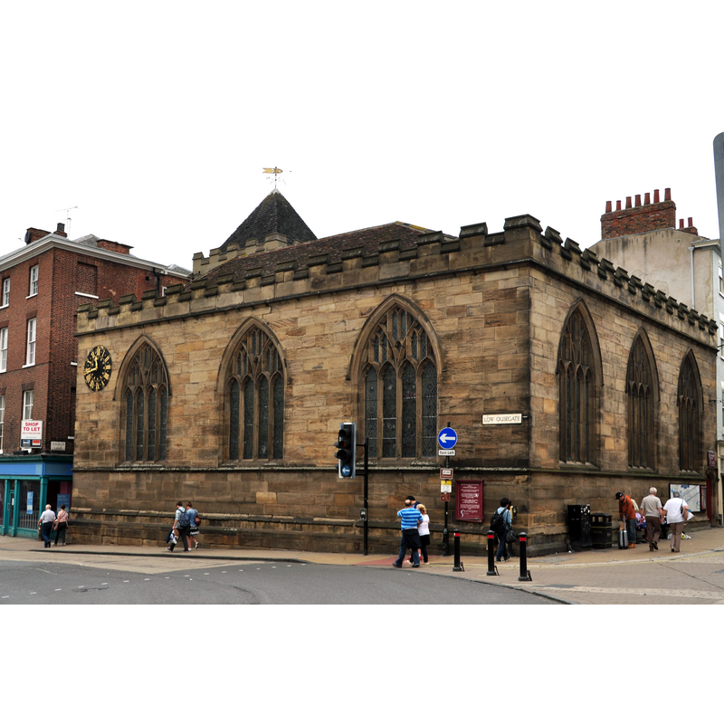
Image copyright © Nilfanion, 2014
CC-BY-SA-3.0
Results: 2 records
view of church exterior in context
Copyright Statement: Image copyright © Nilfanion, 2014
Image Source: digital photograph taken 15 June 2014 by Nilfanion [https://commons.wikimedia.org/wiki/File:St_Michael,_Spurriergate_(8540).jpg] [accessed 27 August 2019]
Copyright Instructions: CC-BY-SA-3.0
view of church interior - detail
![Source caption: "A church existed on the site before the conquest, and the earliest part of the building is 12th century - the nave arcades, when they were probably five bays in length. The north aisle was widened in the 14th century, probably when a Chantry to the Blessed Virgin Mary was added. In the 15th C. the arcades were raised and a clerestory was added, although that has now gone. The south aisle was widened and the west tower built. The church is of a square plan with a fairly narrow nave with broad north and south aisles and a low western tower with six bells, one dating from 1466, the oldest bell in York. There is a fine 18th-century reredos with altar rails. [...] The church possesses much stained-glass from the first half of the 15th century which has been restored and rearranged after the Second World War. All tracery lights have clear glass. Some windows have roundels with geometric patterns from the early 19th century. In 1821 the church was reduced in size to allow Street widening with extensive rebuilding. In 1966 the tower was reduced in height and most of the seating removed. The church became redundant in the 1970's, and has been used as a Christian centre/cafe since 1989."](/static-50478a99ec6f36a15d6234548c59f63da52304e5/compressed/1190831016_compressed.png)
Scene Description: Source caption: "A church existed on the site before the conquest, and the earliest part of the building is 12th century - the nave arcades, when they were probably five bays in length. The north aisle was widened in the 14th century, probably when a Chantry to the Blessed Virgin Mary was added. In the 15th C. the arcades were raised and a clerestory was added, although that has now gone. The south aisle was widened and the west tower built. The church is of a square plan with a fairly narrow nave with broad north and south aisles and a low western tower with six bells, one dating from 1466, the oldest bell in York. There is a fine 18th-century reredos with altar rails. [...] The church possesses much stained-glass from the first half of the 15th century which has been restored and rearranged after the Second World War. All tracery lights have clear glass. Some windows have roundels with geometric patterns from the early 19th century. In 1821 the church was reduced in size to allow Street widening with extensive rebuilding. In 1966 the tower was reduced in height and most of the seating removed. The church became redundant in the 1970's, and has been used as a Christian centre/cafe since 1989."
Copyright Statement: Image copyright © Jules & Jenny, 2015
Image Source: digital photograph taken 7 February 2015 by Jules & Jenny [www.flickr.com/photos/78914786@N06/15957276814] [accessed 27 August 2019]
Copyright Instructions: CC-BY-2.0
INFORMATION
Font ID: 14045YOR
Object Type: Baptismal Font1?
Font Date: pre-1066?
Font Century and Period/Style: 11th century (early?), Pre-Conquest
Church / Chapel Name: Parish Church of St. Michael, Spurriergate [redundant; closed 1984; later used as restaurant, cafe, etc.]
Church Patron Saint(s): St. Michael
Church Address: Low Ousegate, Spurriergate, York YO1 9QR, UK
Site Location: North Yorkshire, Yorkshire and the Humber, England, United Kingdom
Directions to Site: Located at the corner of Spurriergate and Low Ousegate, just N of the bridge, in the old city centre
Ecclesiastic Region: Diocese of York
Historical Region: Hundred of York
Additional Comments: disappeared font? (the one from the medieval church here)
Font Notes:
Click to view
There are twelve entries for York in the Domesday survey [https://opendomesday.org/place/SE6052/york/] [accessed 8 August 2019] eight of which mentions a church in it [cf. infra]. The entry for this parish in the Victoria County History (York, 1961) notes: "The advowson of the church of ST. MICHAEL, Spurriergate, was given to St. Mary's Abbey, probably as part of the foundation grant, by the Conqueror: the church, like other St. Mary's property, is missing from Domesday Book but was confirmed by William II in his general confirmation dated between 1088 and 1093 [...] The church was untouched by the 16th-century reorganization: the benefice was united with St. Mary's, Castlegate, in 1885 but both churches continued to be used for services. St. Michael's was relicensed for marriages in 1953. [...] Internally the prevailing style is of the 13th century but the windows are of the fifteenth: externally, with the exception of the tower, the fabric has been much rebuilt in modern times"; no font mentioned in the VCH entry. The church and a later font are noted in Parker (1847): "A plain Perpendicular Church […] the pillars and caps of the nave arches, which are clustered, with caps of the character of transition from Norman […] The font is a modern baluster, quite ludicrous". The RCHM (York, 1962- ) notes the existence of a pre-Conquest church here. The entry for this church in Historic England [Listing NGR: SE6029551694] notes: "Parish church, now pastoral centre. Late C12 arcades, heightened in C15; C14 north wall, partly rebuilt 1868; mid C15 tower; church size reduced in 1821, when east end and south aisle were rebuilt; tower lowered 1966-67; refurbished 1989. Alterations of 1821 by JB and W Atkinson"; it mentions no font in it. [NB: we have no information on the earlier font(s) of this church]
COORDINATES
UTM: 30U 625804 5980529
Latitude & Longitude (Decimal): 53.957806, -1.082611
Latitude & Longitude (DMS): 53° 57′ 28.1″ N, 1° 4′ 57.4″ W
REFERENCES
- Victoria County History [online], University of London, 1993-. URL: https://www.british-history.ac.uk.
- Great Britain. Royal Commission on Historical Monuments (England), An Inventory of the Historical Monuments in the city of York, London: H.M. Stationary Office, 1962-, vol. 5: 40
- Parker, I. H. [John Henry?], "Architectural notes of the churches and other ancient buildings in the city and neighbourhood of York", Memoirs illustrative of the history and antiques of the county and city of York […], London: J. Murray, 1847, p. 21