Wheldrake / Coldrid
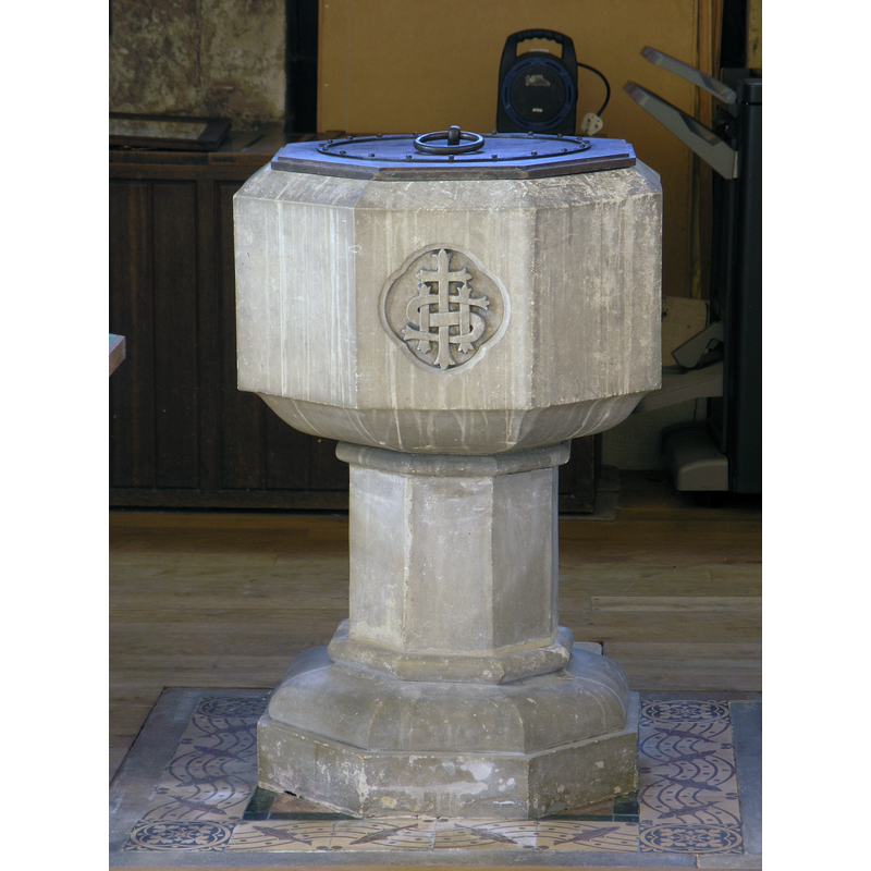
Image copyright © Colin Hinson, 2022
Image and permission received from the author (e-mail of 26 August 2022)
Results: 7 records
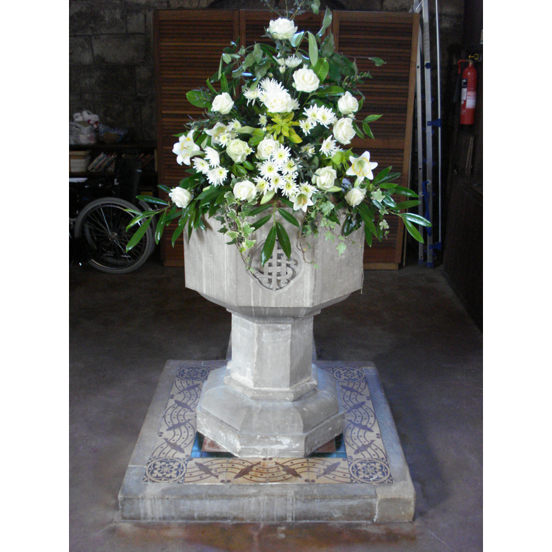
view of font and cover
Scene Description: the modern font in use
Copyright Statement: Image copyright © Colin Hinson, 2022
Image Source: digital photograph 8 April 2022 by Colin Hinson
Copyright Instructions: Image and permission received from the author (e-mail of 26 August 2022)
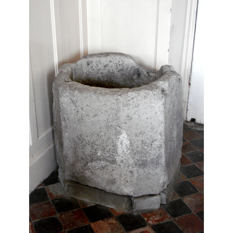
view of font
Scene Description: the ca. 1300 font, now disused
Copyright Statement: Image copyright © Colin Hinson, 2022
Image Source: digital photograph 8 April 2022 by Colin Hinson
Copyright Instructions: Image and permission received from the author (e-mail of 26 August 2022)
view of font
Scene Description: the modern font
Copyright Statement: Image copyright © Richard & Peta Miller, 2009
Image Source: digital photograph taken by Richard and Peta Miller in January 2009
Copyright Instructions: Photographs and permission received via Colin Hinson (e-mail of 10 January 2009)
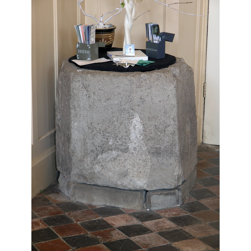
view of font
Scene Description: the ca. 1300 font, now disused
Copyright Statement: Image copyright © Richard & Peta Miller, 2009
Image Source: digital photograph taken by Richard and Peta Miller in January 2009
Copyright Instructions: Photographs and permission received via Colin Hinson (e-mail of 10 January 2009)
view of church exterior - south view
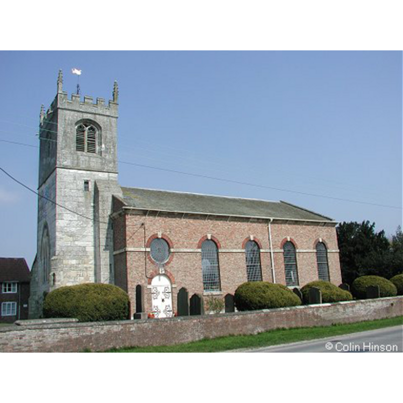
Copyright Statement: Image copyright © Colin Hinson, 2009
Image Source: digital photograph taken 2008 by Colin Hinson [www.yorkshireCDbooks.com]
Copyright Instructions: Standing permission
view of church interior - nave - looking east
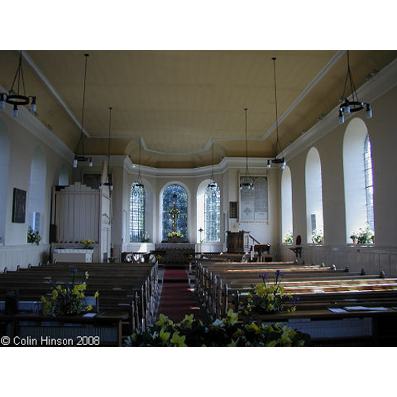
Copyright Statement: Image copyright © Colin Hinson, 2009
Image Source: digital photograph taken 2008 by Colin Hinson [www.yorkshireCDbooks.com]
Copyright Instructions: Standing permission
view of font - detail
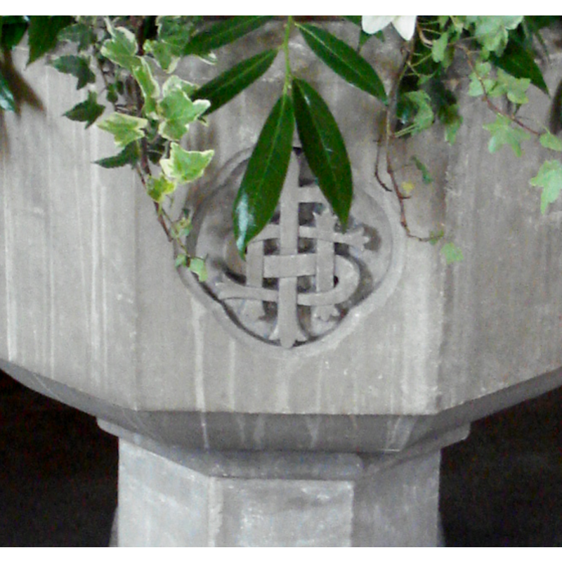
Scene Description: the IHS emblem on the side of the modern font
Copyright Statement: Image copyright © Richard & Peta Miller, 2009
Image Source: digital photograph taken by Richard and Peta Miller in January 2009
Copyright Instructions: Photographs and permission received via Colin Hinson (e-mail of 10 January 2009)
INFORMATION
Font ID: 14016WHE
Object Type: Baptismal Font1
Font Date: ca. 1300?
Font Century and Period/Style: 13th - 14th century, Medieval
Church / Chapel Name: Parish Church of St. Helen
Font Location in Church: [cf. FontNotes]
Church Patron Saint(s): St. Helena
Church Notes: [NB: the original Priory of Thicket (Benedictine nuns) was dissolved and its church demolished; the present priory is a Carmelite monastery of ca. 2000]
Church Address: Main St / Church Ln, Wheldrake, York YO19 6AA , UK
Site Location: East Riding of Yorkshire, Yorkshire and the Humber, England, United Kingdom
Directions to Site: Located off (E) the A19, 11-12 km SE of York
Ecclesiastic Region: Diocese of York
Historical Region: Hundred of Pocklington
Additional Comments: re-cycled font: served as pump trough in a nearby cottage -- have photos MUST USE -- disappeared font? (the one from the Domesday-time church here)
Font Notes:
Click to view
There is an entry for Wheldrake [variant spelling] in the Domesday survey [https://opendomesday.org/place/SE6844/wheldrake/] [accessed 9 September 2019]; it reports a church in it. There is no font mentioned in Glynne's 14 March 1825 visit to this church (in Butler, 2007), but Butler's (ibid.) added footnote reads: "The font is c. 1300". The Victoria County History (York East Riding, vol. 3, 1976) notes: "There was a church at Wheldrake in 1086"; reporting on the changes made during a 19th-century renovation, it adds: "Other changes in 1873 included the removal of a west gallery and the provision of new seating, floors, and font". The same VCH source adds that: "An octagonal font of c. 1300 was restored to the church in 1974". Reported in the 'A Church Near You' site [http://www.achurchnearyou.com/wheldrake-st-helen/] [accessed 26 November 2008]: "The medieval (?1300) font was replaced by one of a slender Georgian style, which is now in the garden of the nursing home next door. For two hundred years the medieval font was a pump trough for a cottage in Main Street […] The Georgian font was removed and was replaced by the present one." In Pevsner & Neave (1995): "Font. Octagonal of c. 1300." On-site notes: the font being used at present [January 2009] is a of the octagonal mounted type, modern; one (?) of the sides of the basin bears the IHS emblem; the lower base is moulded and octagonal. The plinth is quadrangular, the top decorated with tiles. Kept in a corner of the nave is the old octagonal tub; it has a rounded inner well and is much damaged at the top sides. It is now disused [NB: we have no up-to-date information on the Georgian font reported earlier in the churchyard]
Credit and Acknowledgements: We are grateful to Richard and Peta Miller for their photographs of these fonts, and to Colin Hinson, of www.yorkshireCDbooks.com, for his photographs of the church and for his help in documenting these fonts
COORDINATES
UTM: 30U 633883 5973930
Latitude & Longitude (Decimal): 53.8965, -0.962453
Latitude & Longitude (DMS): 53° 53′ 47.4″ N, 0° 57′ 44.83″ W
MEDIUM AND MEASUREMENTS
Material: stone
Font Shape: octagonal
Basin Interior Shape: round
Basin Exterior Shape: octagonal
Drainage System: centre hole in basin
Drainage Notes: no lining
REFERENCES
- Victoria County History [online], University of London, 1993-. URL: https://www.british-history.ac.uk.
- Victoria County History [online], University of London, 1993-. URL: https://www.british-history.ac.uk.
- Glynne, Stephen Richard, The Yorkshire notes of Sir Stephen Glynne (1825-1874), Woodbridge: The Boydell Press; Yorkshire Archaeological Society, 2007, p, 438 fn1
- Pevsner, Nikolaus, Yorkshire: York and the East Riding, London: Penguin, 1995, p. 752