Kirby Wiske / Chirchebi / Kierkebi upon Wisch / Kirkby Wiske / Kirkebi / Kirkeby wysk
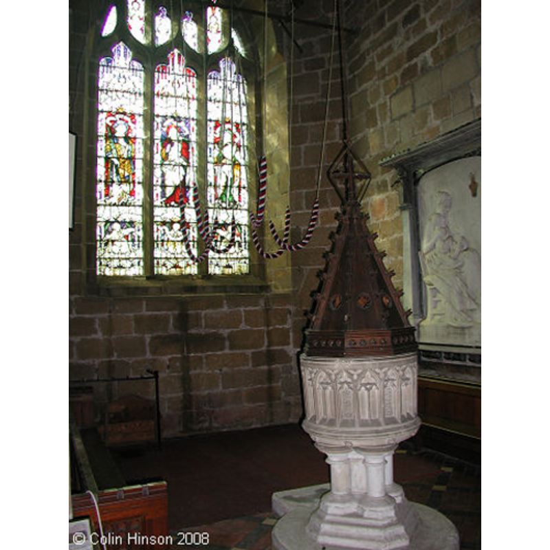
Image copyright © Colin Hinson, 2008
Standing permission
Results: 5 records
view of font and cover in context
Scene Description: the 19th-century font beneath the tower
Copyright Statement: Image copyright © Colin Hinson, 2008
Image Source: digital photograph taken in 2008 by Colin Hinson
Copyright Instructions: Standing permission
view of font
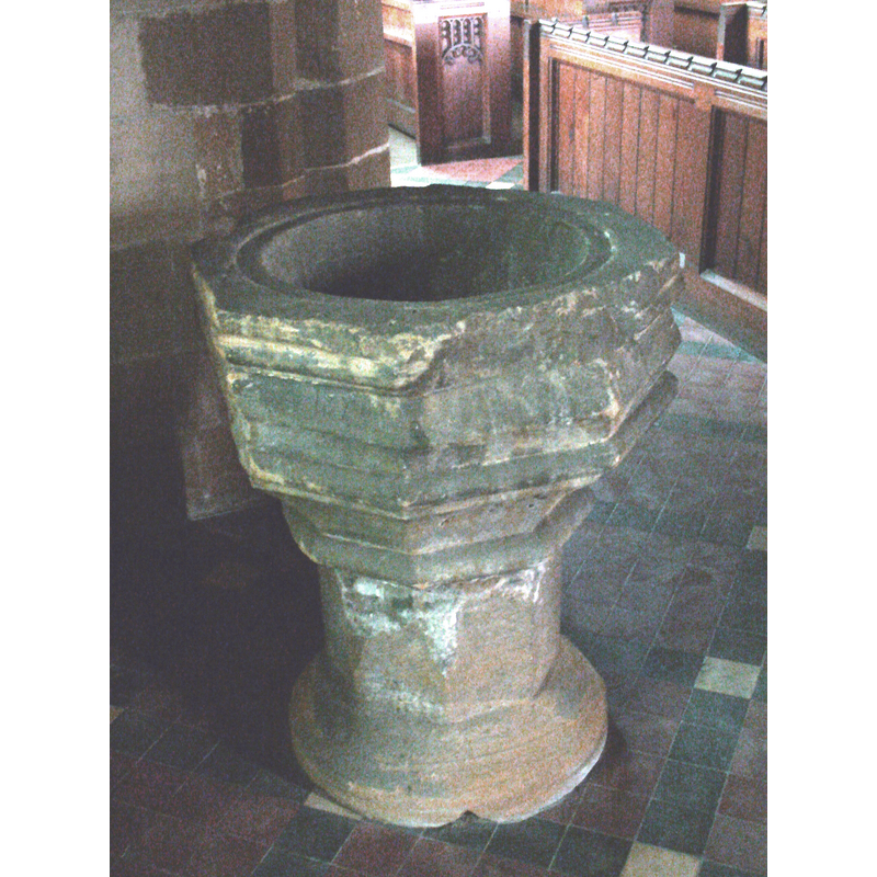
Scene Description: the 14th-century (?) font, now disused
Copyright Statement: Image copyright © Colin Smith, 2009
Image Source: digital photograph taken 28 August 2009 by Colin Smith
Copyright Instructions: Standing permission
design element - motifs - moulding
Copyright Statement: Image copyright © Colin Smith, 2009
Image Source: digital photograph taken 28 August 2009 by Colin Smith
Copyright Instructions: Standing permission
view of church exterior - south view
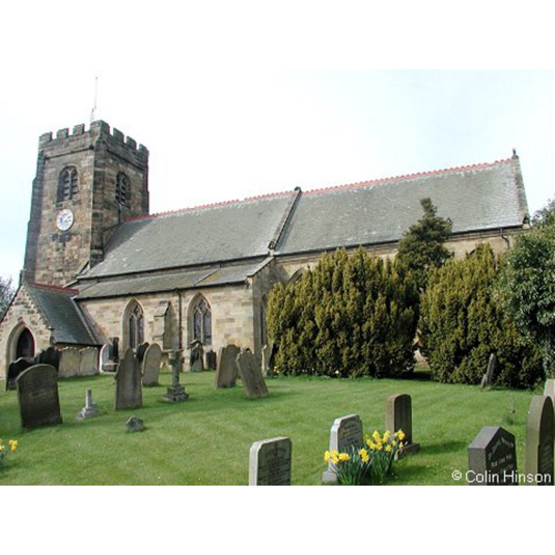
Copyright Statement: Image copyright © Colin Hinson, 2008
Image Source: digital photograph taken in 2008 by Colin Hinson
Copyright Instructions: Standing permission
view of church interior - nave - west end
![the two fonts: the 19th-century font and cover is beneath the tower [the coloured ropes are the bell-ringing ropes]; the earlier font in the foreground](/static-50478a99ec6f36a15d6234548c59f63da52304e5/compressed/1090907005_compressed.png)
Scene Description: the two fonts: the 19th-century font and cover is beneath the tower [the coloured ropes are the bell-ringing ropes]; the earlier font in the foreground
Copyright Statement: Image copyright © Colin Smith, 2009
Image Source: digital photograph taken 28 August 2009 by Colin Smith
Copyright Instructions: Standing permission
INFORMATION
Font ID: 13970KIR
Object Type: Baptismal Font1
Font Century and Period/Style: 14th century, Decorated
Church / Chapel Name: Parish Church of St. John the Baptist
Font Location in Church: Inside the church, at the W end [cf. FontNotes]
Church Patron Saint(s): St. John the Baptist
Church Address: Main St, Kirby Wiske, Thirsk YO7 4ES, UK
Site Location: North Yorkshire, Yorkshire and the Humber, England, United Kingdom
Directions to Site: Located off (W) the A167 and the Wiske river, 7 km WNW of Thirsk, S of Northallerton
Ecclesiastic Region: Diocese of Leeds
Historical Region: Hundred of Land of Count Alan
Additional Comments: disused font / abandoned font / restored font
Font Notes:
Click to view
There are two entries [one is multiple-place] for Kirby [Wiske] [variant spelling] in the Domesday surcvey [https://opendomesday.org/place/SE3784/kirby-wiske/] [accessed 14 November 2019] neither of which mentions cleric or church in it. The entry for this parish in the Victoria County History (York North Riding, vol. 1, 1914) notes: "In 1182 Henry II confirmed the grant of William de Kirkby Wiske of this church to the Prior of Guisborough [...] The history of the church begins in the 12th century, when it consisted of a nave and a chancel. Very little of this church is now left, the most important parts being a small piece of the original south wall, now at the west end of the south nave arcade, the fine south doorway, which belongs to about 1160, [...] and some grotesque head corbels now used to support the south aisle roof over the arcade. [...] There are two fonts, a modern one placed under the tower arch and an old one, not now in use, in the north-west angle of the nave. Its date is uncertain, but it has probably been recut in the 15th century. The bowl and stem are octagonal, the former being coarsely moulded, with one side cut away, as though it had been against a wall." There are at present [August 2009] two baptismal fonts inside this church: one appears 19th-century, with a matchin cover, both dating probably from the Victorian restoration of the building that was announced in 'The Architect' (issue of 21 Oct. 1871. p. 207): "it has been decided to restore this parish Church". The other one, older, is probably from the expansion that the original Norman church underwent in the 14th century; the latter consists of an octagonal basin with moulded sides, one of which is badly damaged; it stands on an octagonal pedestal base with a round splaying lower base; it is now disused, and it is obvious it has been kept outdoors for a long time before being restored to the church again. The entry for this church in Historic England [Listing NGR: SE3763084832] notes: "Church. C12, C14, C15 and C19"; no font mentioned in it. [NB: we have no information on the original font of the Norman church]
Credit and Acknowledgements: We are grateful to Colin Hinson, of www.yorkshireCDbooks.com, and to Colin Smith, for their photographs of church and fonts
COORDINATES
UTM: 30U 602642 6013318
Latitude & Longitude (Decimal): 54.2575, -1.424331
Latitude & Longitude (DMS): 54° 15′ 27″ N, 1° 25′ 27.59″ W
MEDIUM AND MEASUREMENTS
Material: stone
Font Shape: octagonal, mounted
Basin Interior Shape: round
Basin Exterior Shape: octagonal
Drainage System: centre hole in basin
REFERENCES
- Victoria County History [online], University of London, 1993-. URL: https://www.british-history.ac.uk.