Emneth / Enemeth / Enmeth
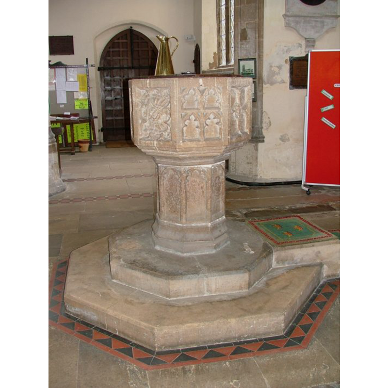
Image copyright © Simon Knott, 2008
Standing permission
Results: 12 records
view of font and cover in context
Copyright Statement: Image copyright © Simon Knott, 2008
Image Source: digital photograph by Simon Knott [www.norfolkchurches.co.uk/emneth/emneth.htm] [accessed 4 November 2008]
Copyright Instructions: Standing permission
design element - motifs - tracery - varied
![[cf. Font notes]](/static-50478a99ec6f36a15d6234548c59f63da52304e5/compressed/1081104006_compressed.png)
Scene Description: [cf. Font notes]
Copyright Statement: Image copyright © Simon Knott, 2008
Image Source: digital photograph by Simon Knott [www.norfolkchurches.co.uk/emneth/emneth.htm] [accessed 4 November 2008]
Copyright Instructions: Standing permission
design element - motifs - moulding - graded
Scene Description: [cf. Font notes]
Copyright Statement: Image copyright © Simon Knott, 2008
Image Source: digital photograph by Simon Knott [www.norfolkchurches.co.uk/emneth/emneth.htm] [accessed 4 November 2008]
Copyright Instructions: Standing permission
design element - architectural - arch or window - cinquefoiled - 8
Scene Description: [cf. Font notes]
Copyright Statement: Image copyright © Simon Knott, 2008
Image Source: digital photograph by Simon Knott [www.norfolkchurches.co.uk/emneth/emneth.htm] [accessed 4 November 2008]
Copyright Instructions: Standing permission
view of church exterior - southwest view
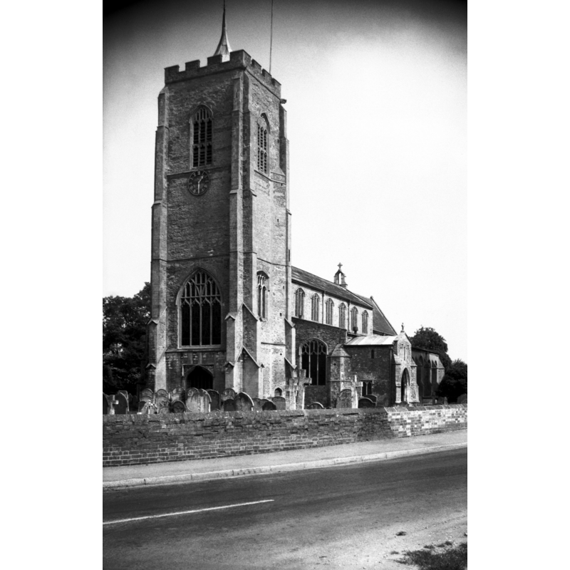
Copyright Statement: Image copyright © George Plunkett, 2013
Image Source: B&W photograph taken 21 August 1976 by George Plunkett [www.georgeplunkett.co.uk/Norfolk/E/Emneth St Edmund's church from SW [5657] 1976-08-21.jpg] [accessed 13 November 2013]
Copyright Instructions: Standing permission by Jonathan Plunkett
view of church exterior - east view
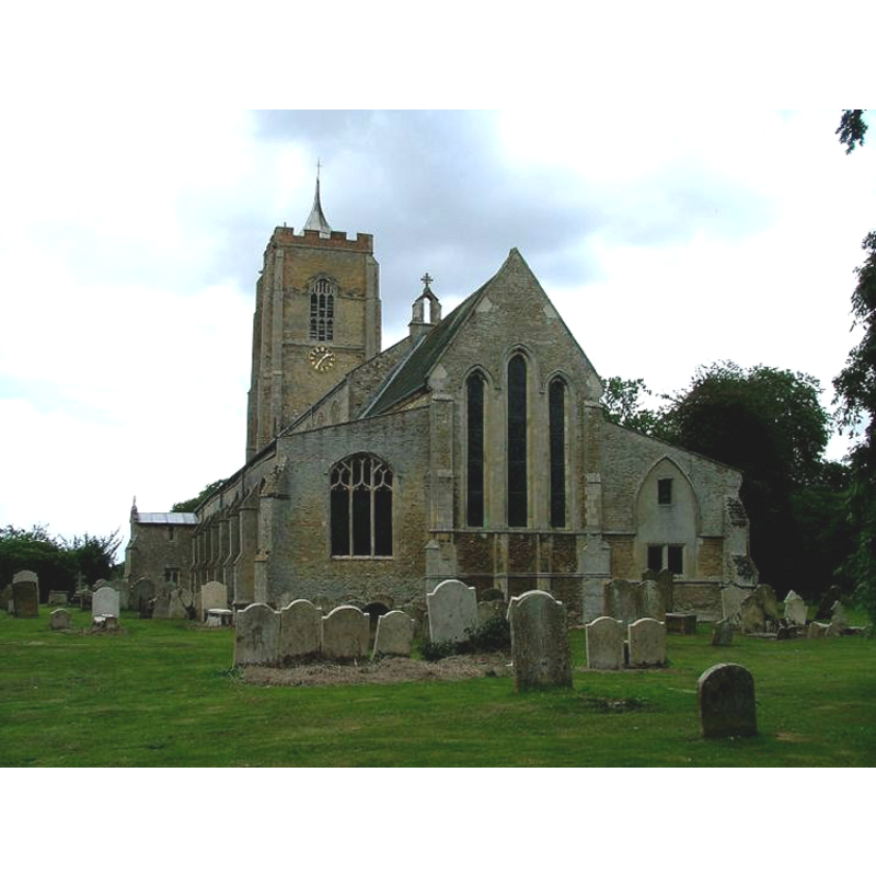
Copyright Statement: Image copyright © Simon Knott, 2008
Image Source: digital photograph by Simon Knott [www.norfolkchurches.co.uk/emneth/emneth.htm] [accessed 4 November 2008]
Copyright Instructions: Standing permission
view of church interior - nave - ceiling
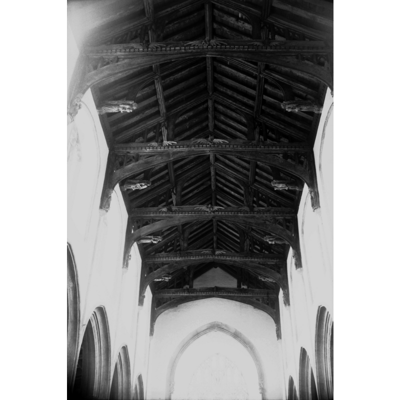
Copyright Statement: Image copyright © George Plunkett, 2013
Image Source: B&W photograph taken 21 August 1976 by George Plunkett [www.georgeplunkett.co.uk/Norfolk/E/Emneth St Edmund's church 15c nave roof W [5658] 1976-08-21.jpg] [accessed 13 November 2013]
Copyright Instructions: Standing permission by Jonathan Plunkett
view of church interior - nave - looking east
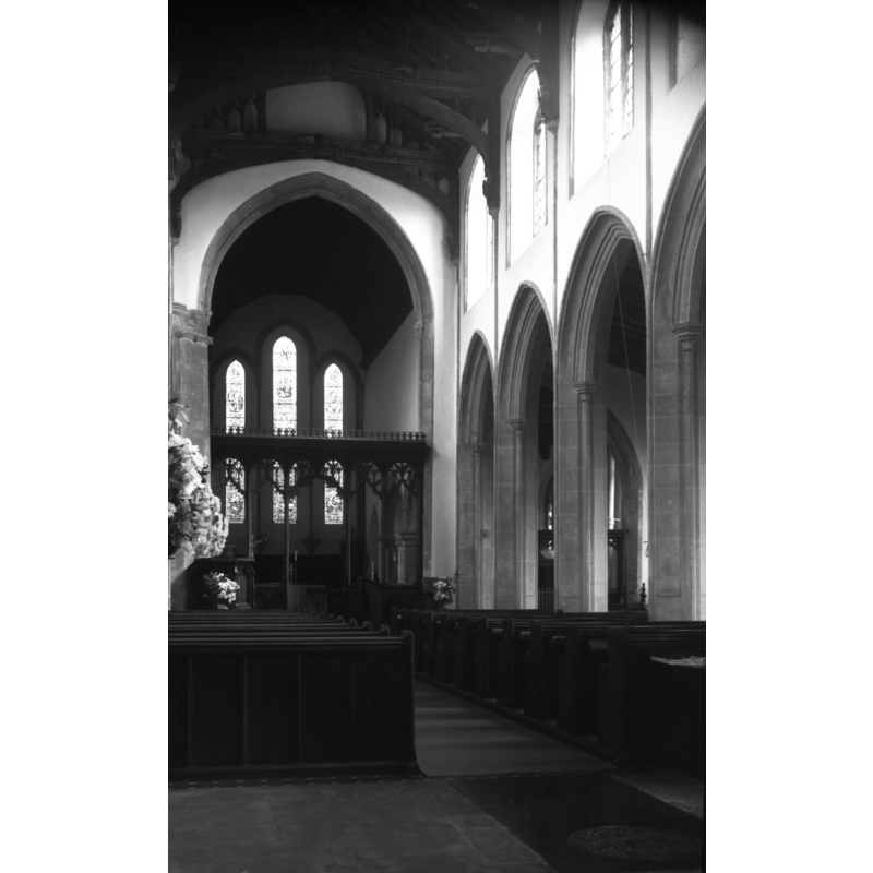
Copyright Statement: Image copyright © George Plunkett, 2013
Image Source: B&W photograph taken 21 August 1976 by George Plunkett [www.georgeplunkett.co.uk/Norfolk/E/Emneth St Edmund's church interior view E [5659] 1976-08-21.jpg] [accessed 13 November 2013]
Copyright Instructions: Standing permission by Jonathan Plunkett
view of church interior - nave - looking west
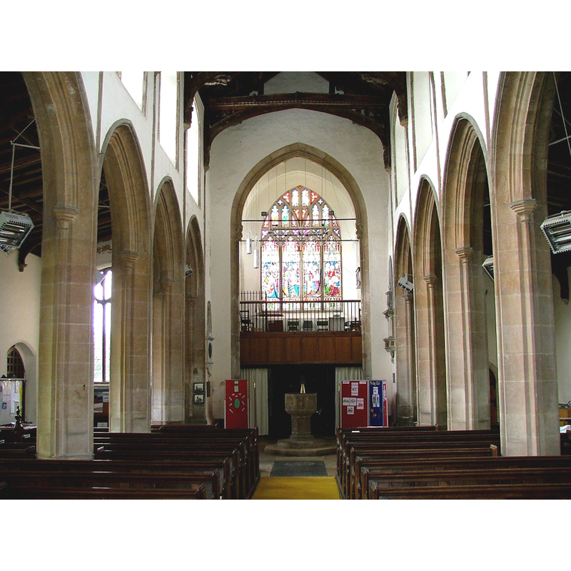
Scene Description: the font at the back, under the gallery
Copyright Statement: Image copyright © Simon Knott, 2008
Image Source: digital photograph by Simon Knott [www.norfolkchurches.co.uk/emneth/emneth.htm] [accessed 4 November 2008]
Copyright Instructions: Standing permission
view of church interior - nave - looking east
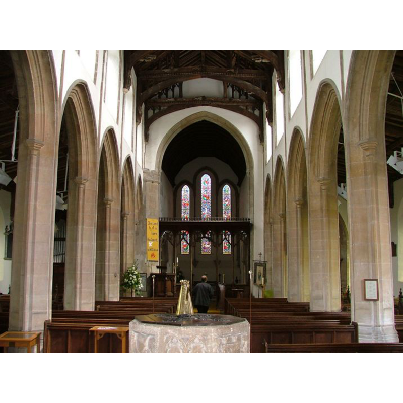
Scene Description: the top of the font in the foreground
Copyright Statement: Image copyright © Simon Knott, 2008
Image Source: digital photograph by Simon Knott [www.norfolkchurches.co.uk/emneth/emneth.htm] [accessed 4 November 2008]
Copyright Instructions: Standing permission
design element - motifs - moulding
Scene Description: on the bottom of the stem [cf. Font notes]
Copyright Statement: Image copyright © Simon Knott, 2008
Image Source: digital photograph by Simon Knott [www.norfolkchurches.co.uk/emneth/emneth.htm] [accessed 4 November 2008]
Copyright Instructions: Standing permission
angel - holding shield
![this is noted only in Pevsner & Wilson (1999) [cf. Font notes]; we have no photographic evidence of it](/static-50478a99ec6f36a15d6234548c59f63da52304e5/others/image_not_available.jpg)
Scene Description: this is noted only in Pevsner & Wilson (1999) [cf. Font notes]; we have no photographic evidence of it
![this is noted only in Pevsner & Wilson (1999) [cf. Font notes]; we have no photographic evidence of it](/static-50478a99ec6f36a15d6234548c59f63da52304e5/bsi-testing-site/others/image_not_available.jpg)
INFORMATION
Font ID: 13956EMN
Object Type: Baptismal Font1
Font Century and Period/Style: 15th century (late?), Perpendicular
Workshop/Group/Artisan: heraldic font
Church / Chapel Name: Parish Church of St. Edmund
Font Location in Church: Inside the church, in the W end of the nave
Church Patron Saint(s): St. Edmund the Martyr [aka Edmund of East Anglia]
Church Address: Church Road, Emneth, Norfolk PE14 8AF
Site Location: Norfolk, East Anglia, England, United Kingdom
Directions to Site: Located on the A1101, just S of Wisbech and Walsoken, 20 km SW of King's Lynn, at the border with Cambridgeshire [NB: the county is often given as Cambridgeshire]
Ecclesiastic Region: Diocese of Ely
Historical Region: Hundred and half of Freebridge -- Emneth was a hamlet in the parish of Elm, Cambridgeshire, but belonged to Norfolk
Additional Comments: disappeared font? (the one from the mid-13thC church here)
Font Notes:
Click to view
There is no entry for Emneth/Enmeth in the Domesday survey. Blomefield (1805-1810) writes: "E[mneth], or E[nemeth], [...] is an hamlet in the parish of Elm in Cambridgeshire, and the isle of Ely; but this hamlet being in Freebridge hundred and in the county of Norfolk [...] To this hamlet belongs a large chapel, larger than most churches, having a nave, north and south isle, and a chancel dedicated to St. Edmund the King and Martyr. Elm is the mother-church, has a rector, and a vicar, both in the pationage of the see of Ely; the rectory is a sinecure". Blomefield (ibid.) names "Walter de Kirkham, rector about 1250" as first-recorded rector, and "Peter occurs vicar about 1254". The Ecclesiologist (XXVIII, 1867: 8) unexplicably notes the font here as "well designed, but plain". Described in Pevsner & Wilson (1999): "Perp[endicular], octagonal, with tracery and foliage motifs. Also an angel with a shield." Described and illustrated in Simon Knott (2005): "a good traceried font of the late 15th century". The font consists of an octagonal basin with vertical sides decorated with varied tracery patterns, the underbowl with graded mouldings, on an octagonal pedestal base decorated with foiled panels and moulded lower part, on a two-step plinth with kneeling extension. The wooden cover is octagonal and flat, with metal decoration and ring handle; appears modern.
Credit and Acknowledgements: We are grateful to Simon Knott, of www.norfolkchurches.co.uk, for his photographs of church and font; we are also grateful to Jonathan Plunkett for the photographs of this church taken by his father, George Plunkett, 21 August 1986
COORDINATES
UTM: 31U 310461 5836326
Latitude & Longitude (Decimal): 52.643746, 0.198417
Latitude & Longitude (DMS): 52° 38′ 37.49″ N, 0° 11′ 54.3″ E
MEDIUM AND MEASUREMENTS
Material: stone
Font Shape: octagonal, mounted
Basin Interior Shape: round
Basin Exterior Shape: octagonal
LID INFORMATION
Date: modern?
Material: wood
Apparatus: no
Notes: flat and plain; appears modern
REFERENCES
- Blomefield, Francis, An essay towards a topographical history of Norfolk, 1805-1810, vol. 8: 403-410 / [www.british-history.ac.uk/report.aspx?compid=78484] [accessed 13 November 2013]
- Knott, Simon, The Norfolk Churches Site, Simon Knott, 2004. [standing permission to reproduce images received from Simon (February 2005]. URL: www.norfolkchurches.co.uk.