Headley nr Bordon / Hallege / Heathley / Hedle / Hedleigh / Hedley / Hertelegh / Hethelie / Hetlegh
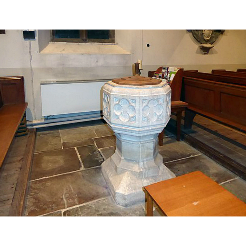
Image copyright © Basher Eyre, 2016
CC-BY-SA-2.0
Results: 6 records
view of font in context
Copyright Statement: Image copyright © Basher Eyre, 2016
Image Source: digital photograph taken 17 January 2016 by Basher Eyre [www.geograph.org.uk/photo/4796358] [accessed 19 June 2018]
Copyright Instructions: CC-BY-SA-2.0
design element - motifs - panel - quatrefoiled - 8
Scene Description: [cf. Font notes]
Copyright Statement: Image copyright © Basher Eyre, 2016
Image Source: digital photograph taken 17 January 2016 by Basher Eyre [www.geograph.org.uk/photo/4796358] [accessed 19 June 2018]
Copyright Instructions: CC-BY-SA-2.0
design element - motifs - moulding
Scene Description: [cf. Font notes]
Copyright Statement: Image copyright © Basher Eyre, 2016
Image Source: digital photograph taken 17 January 2016 by Basher Eyre [www.geograph.org.uk/photo/4796358] [accessed 19 June 2018]
Copyright Instructions: CC-BY-SA-2.0
design element - motifs - moulding - graded
Scene Description: [cf. Font notes]
Copyright Statement: Image copyright © Basher Eyre, 2016
Image Source: digital photograph taken 17 January 2016 by Basher Eyre [www.geograph.org.uk/photo/4796358] [accessed 19 June 2018]
Copyright Instructions: CC-BY-SA-2.0
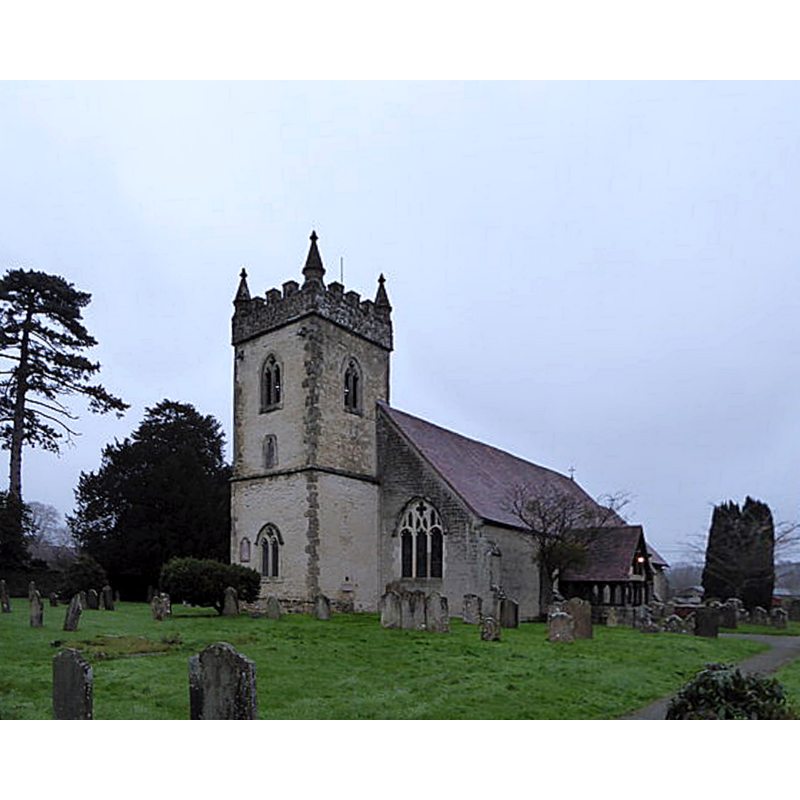
view of church exterior - southwest view
Copyright Statement: Image copyright © Basher Eyre, 2016
Image Source: digital photograph taken 17 January 2016 by Basher Eyre [www.geograph.org.uk/photo/4795805] [accessed 19 June 2018]
Copyright Instructions: CC-BY-SA-2.0
design element - motifs - moulding
Scene Description: [cf. Font notes]
Copyright Statement: Image copyright © Basher Eyre, 2016
Image Source: digital photograph taken 17 January 2016 by Basher Eyre [www.geograph.org.uk/photo/4796358] [accessed 19 June 2018]
Copyright Instructions: CC-BY-SA-2.0
INFORMATION
Font ID: 13731HEA
Object Type: Baptismal Font1
Font Century and Period/Style: 15th century [re-tooled?] / 19th century, Perpendicular [altered?]
Church / Chapel Name: Parish Church of All Saints
Font Location in Church: Inside the church
Church Patron Saint(s): All Saints
Church Address: 2 High St, Headley, Bordon GU35 8PP, UK
Site Location: Hampshire, South East, England, United Kingdom
Directions to Site: Located on the B3002, 3 km ENE of Bordon, 6 km N of Liphook, 11 km SE of Newbury [NB: not to be mistaken with another Headley in north Hampshire, also with a church dedicated to All Saints]
Ecclesiastic Region: Diocese of Guilford
Historical Region: Hundred of Bishop's Sutton -- Hundred of Neatham [in Domesday]
Additional Comments: re-tooled font? / Disappeared font? (the one from the ca. 1317 church here [cf. FontNotes])
Font Notes:
Click to view
There is an entry for this Headley [variant spelling] in the Domesday survey [http://opendomesday.org/place/SU8236/headley/] [accessed 19 June 2018], but it mentions neither priest nor church in it. Baptismal font consisting of an octagonal basin with vertical sides decorated with large quatrefoil panels between mouldings at the upper rim, and a graded moulded chamfer at the underbowl; moulding again at the upper end of the octagonal pedestal; splaying lower base. It appears to be of 15th-century Perpendicular design, but the Victoria County History (Hampshire, vol. 3, 1908) states: "The font is modern". A description of this church from 1935 by Philip M. Johnston, architect, and J.S. Tudor-Jones, Rector [http://www.johnowensmith.co.uk/headley/ch1935.htm] [accessed 1 September 2008], however, notes: "all the fittings and furnishings of the Church are modern, except, perhaps, the Font, of 15th century type, octagonal, with quatrefoil panels on the bowl. This, if old, has been re-worked". The entry for this church in Historic England [Listing NGR: SU8217236177] a pair of early-16th century brasses located "Beside the font", but gives no particulars of the latter. [NB: the church itself may date back at least to 1317, when, according to the VCH entry, "the rectory of Headley was appropriated to Merton Priory subsequent to 1317", but, if this font is a modern one, we have no other information of the original].
COORDINATES
UTM: 30U 652056 5665431
Latitude & Longitude (Decimal): 51.12015, -0.8273
Latitude & Longitude (DMS): 51° 7′ 12.54″ N, 0° 49′ 38.28″ W
MEDIUM AND MEASUREMENTS
Material: stone
Font Shape: octagonal, mounted
Basin Interior Shape: round
Basin Exterior Shape: octagonal
REFERENCES
- Victoria County History [online], University of London, 1993-. URL: https://www.british-history.ac.uk.