Ripple nr. Tewksbury / Repell / Rippel / Rippell / Ryppull
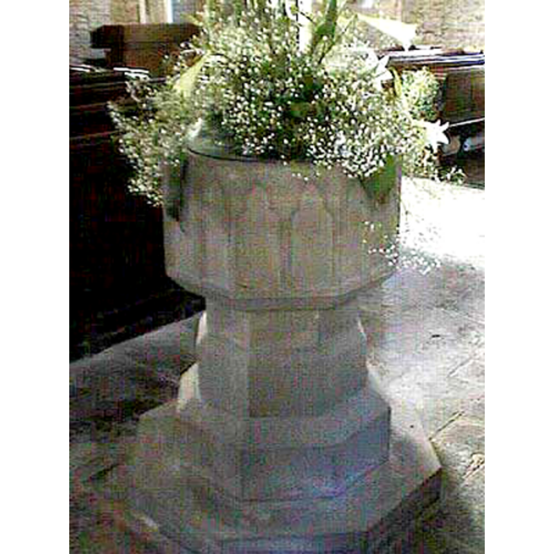
Image copyright © John Wilkes, 2008
Standing permission
Results: 3 records
view of font
Copyright Statement: Image copyright © John Wilkes, 2008
Image Source: digital photograph taken by John Wilkes 29 June 2008
Copyright Instructions: Standing permission
design element - architectural - arcade - blind - trefoiled arches - 16 arches
Scene Description: [cf. FontNotes]
Copyright Statement: Image copyright © John Wilkes, 2008
Image Source: digital photograph taken by John Wilkes 29 June 2008
Copyright Instructions: Standing permission
view of church exterior - southeast view
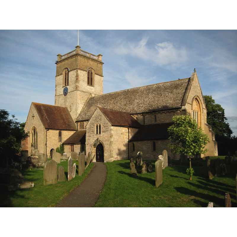
Copyright Statement: Image copyright © Philip Halling, 2008
Image Source: digital photograph taken 21 July 2008 by Philip Halling [www.geograph.org.uk/photo/899122] [accessed 30 September 2014]
Copyright Instructions: CC-BY-SA-2.0
INFORMATION
Font ID: 13569RIP
Object Type: Baptismal Font1
Font Date: ca. 1300?
Font Century and Period/Style: 13th - 14th century [re-tooled / re-cut in 1851], Early English [altered]
Church / Chapel Name: Parish Church of St. Mary the Virgin
Font Location in Church: Inside the church
Church Patron Saint(s): St. Mary the Virgin
Church Address: Station Road, Ripple, Worcestershire GL20 6EZ
Site Location: Worcestershire, West Midlands, England, United Kingdom
Directions to Site: Located on the A38, 5 km N of Tewkesbury
Ecclesiastic Region: Diocese of Worcester
Historical Region: Hundred of Oswaldslow [in Domesday] -- Hundred of Halfshire
Additional Comments: altered font (the present one: re-cut / re-tooled) -- disappeared font? (the one from the likely Domesday-time church here)
Font Notes:
Click to view
There is entry for Ripple [variant spelling] in the Domesday survey [http://domesdaymap.co.uk/place/SO8737/ripple/] [accessed 30 September 2014]; it reports two priests but mentions no church, though there probably was one there. Miller (1890) reports a modern font in this handsome church of Norman origins. The Victoria County History (Worcester, vol. 3, 1913) notes: "The church of St. Mary, Ripple, may have existed at the time of the Norman Conquest, having possibly been served by the two priests here, mentioned in the Domesday Survey. [...] It is probable that a church has stood on this site since the end of the 11th century. A fragment of the sculptured head of a small round-arched light, now built into the north wall of the nave, cannot well be later. The earliest details now in situ are the late 12th-century south doorway and the jambs of a blocked north doorway of the same date." The VCH (ibid.) reports the 12th-century base on the font at nearby Queenhill [cf. Index entry]. A font here is noted in Pevsner (1968): "Font. Of c.1300, octagonal, of the Purbeck type, but the blank arches pointed-trefoiled. The font was re-tooled in 1851." In Brooks & Pevsner (2007). Edward F Gray, in his 'Church Building: History of Ripple Church' [http://stmarysripple.weebly.com/building.html] [accessed 5 October 2014] writes: "The Font may at first glance appear modern. It is, however, really pre-Reformation. Combining records from a Church inventory, from Noakes’ account of a visit here, and from the bill of a Ripple stonemason in the Church accounts, it is evident that the font was found in a cowshed where it was used as a drinking trough; cleaned, re-worked and partly re-pieced by John Brush, 10 May 1851; and replaced in the Church instead of the font now in Earl’s Croome Church. The font cover was made by a Twyning carpenter, John Housman. On careful examination it will be seen that Brush’s repairs included work on the rims of the font where an earlier font cover had been prised off, leaving rude scars. Various authorities tell us that fonts were lidded and padlocked before the Reformation to prevent the water, not often renewed, being stolen as an ingredient for witches’ nostrums. Other signs of early origin are the tracery adornments round the font which correspond with those of the two windows near it. E Tyrrell Green explains that 14th and 15th century fonts exhibit this peculiarity."
Credit and Acknowledgements: We are grateful to John Wilkes, of www.allthecotswolds.com, for his photographs of church and font
COORDINATES
UTM: 30U 556126 5765532
Latitude & Longitude (Decimal): 52.037562, -2.181746
Latitude & Longitude (DMS): 52° 2′ 15.22″ N, 2° 10′ 54.29″ W
MEDIUM AND MEASUREMENTS
Material: stone
Font Shape: octagonal, mounted
Basin Interior Shape: round
Basin Exterior Shape: octagonal
REFERENCES
- Victoria County History [online], University of London, 1993-. URL: https://www.british-history.ac.uk.
- Brooks, Alan, Worcestershire, New Haven; London: Yale University Press, 2007, p. 575
- Miller, George [Revd.], The Parishes of the Diocese of Worcester, Birmingham: Hall & English, 1890, vol. 2: 125-127
- Pevsner, Nikolaus, Worcestershire, Harmondsworth: Penguin, 1968