Burmington / Burdintone
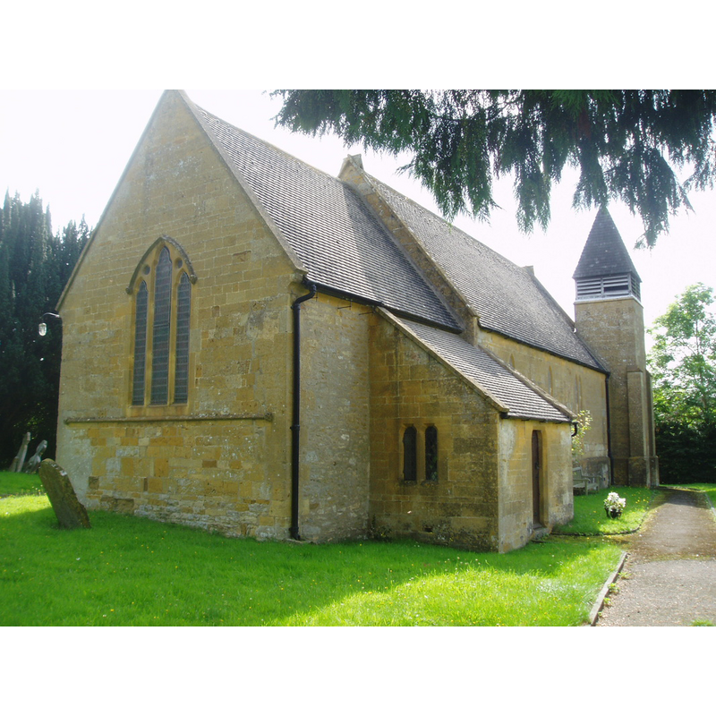
Image copyright © Aidan McRae Thomson, 2015
Standing permission
Results: 3 records
view of church exterior - northeast view
Copyright Statement: Image copyright © Aidan McRae Thomson, 2015
Image Source: igital photograph taken 8 August 2009 by Aidan McRae Thomson [http://warwickshirechurches.weebly.com/burmington---ss-barnabas--nicholas.html] [accessed 19 December 2014]
Copyright Instructions: Standing permission
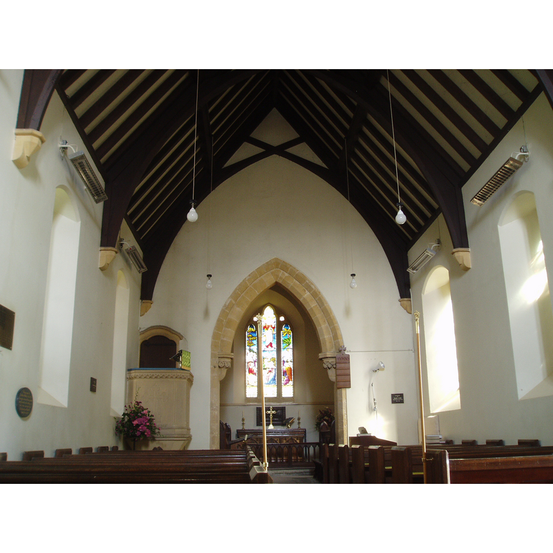
view of church interior - nave - looking east
Scene Description: Source caption: "BURMINGTON, St. Nicholas (1849). BURMINGTON groundplan and gallery created by ?JOHNSON, Thomas: b. 1794 - d. 1865 of Lichfield;JOHNSON (THOMAS) & SON"
Copyright Statement: Image copyright © Aidan McRae Thomson, 2015
Image Source: digital photograph taken 8 August 2009 by Aidan McRae Thomson [www.flickr.com/photos/amthomson/3901303690/in/set-72157616538448949] [accessed 19 December 2014]
Copyright Instructions: Standing permission
view of church interior - plan
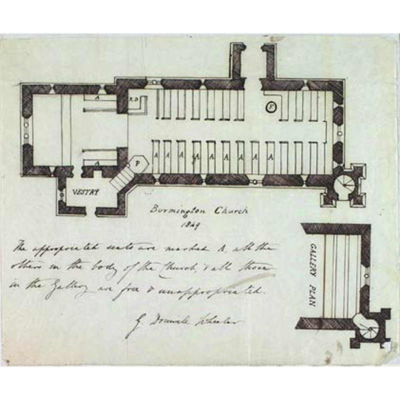
Scene Description: the old plan shows a font (encircled F) at the southwest corner of the nave, just west of the south entranceway
Copyright Statement: Image copyright © Church Plans Online, 2015
Image Source: 1849 drawing in Church Plans Online [www.churchplansonline.org/image_collections/jpegs/04126a.jpg] [accessed 19 December 2014]
Copyright Instructions: No known copyright restriction – Fair Dealing
INFORMATION
Font ID: 13552BUR
Object Type: Baptismal Font1
Font Century and Period/Style: Medieval [altered]
Church / Chapel Name: Parish Church of St. Barnabas and St. Nicholas
Font Location in Church: Inside the church, at the SW end of the nave
Church Patron Saint(s): St. Barnabas [aka Barnabus, Bernabé] & St. Nicholas
Church Address: Main Street, Burmington, Shipston-on-Stour CV36 5AG, United Kingdom -- Tel.: +44 1608 684207
Site Location: Warwickshire, West Midlands, England, United Kingdom
Directions to Site: Located off (E) the A3400, 2 km S of Shipston-on-Stour, 50-60 km SSE of Birmingham
Ecclesiastic Region: Diocese of Coventry
Historical Region: Hundred of Barcheston [in Domesday] -- Hundred of Kington
Additional Comments: altered font? (originally medieval? re-tooled? -- is this the font of the ca.1200 church here?)
Font Notes:
Click to view
There is entry for Burmington [variant spelling] in the Domesday survey [http://domesdaymap.co.uk/place/SP2637/burmington/] [accessed 19 December 2014], but it mentions neither cleric nor church in it. Kelly's Directory of Warwickshire for 1896 reports "an ancient font" in Burmington church. The Victoria County History (Warwick, vol. 5, 1949) notes: "There is a fair amount of medieval masonry in the church walls perhaps dating from as early as the 13th century, but the only ancient architectural detail surviving is part of the chancel arch of c. 1200. The church had fallen into decay and the nave was rebuilt in 1693; it formerly had a central tower, 16 ft. square, but this was then abolished and the chancel reduced in size. [...] A further very complete restoration was also carried out in the 19th century when all the windows, doorways, and roofs were renewed, the bell-turret added, and other work done. [...] The font, a plain one of flower-pot shape, is probably medieval work re-tooled and stands on a chamfered base." English Heritage [Listing NGR: SP2636237946] (1966) reports: "Font is possibly medieval, re-worked".
Credit and Acknowledgements: We are grateful to Aidan McRae Thomson, of Warwickshire Churches [warwickshirechurches.weebly.com/], for his photographs of this church
COORDINATES
UTM: 30U 594853 5766311
Latitude & Longitude (Decimal): 52.039296, -1.617083
Latitude & Longitude (DMS): 52° 2′ 21.47″ N, 1° 37′ 1.5″ W
MEDIUM AND MEASUREMENTS
Material: stone
Font Shape: round
Basin Interior Shape: round
Basin Exterior Shape: round
REFERENCES
- Victoria County History [online], University of London, 1993-. URL: https://www.british-history.ac.uk.