Eldersfield / Eddrefeld / Edresfelle / Eldesfreld / Eldresfelda / Heldresseld / Yldresfelda
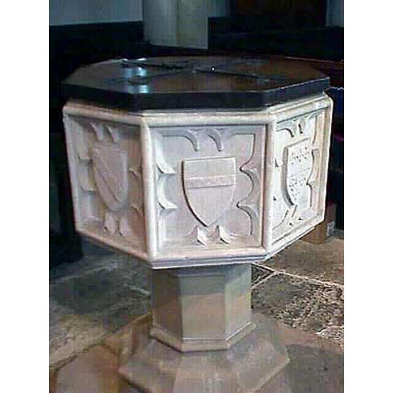
Image copyright © John Wilkes, 2007
Standing permission
Results: 13 records
B01: symbol - shield - coat of arms - Brydges


B02: symbol - shield - coat of arms - Berkeley of Coberley
B03: symbol - shield - coat of arms - Despencer
B04: symbol - shield - coat of arms - Beauchamp
B05: symbol - shield - coat of arms - Whittington
B06: symbol - shield - coat of arms - Ruyhale
B07: symbol - shield - coat of arms - Underhale
B09: symbol - shield - coat of arms - unidentified
Scene Description: "three pine apples" [cf. Font notes]
view of font and cover
Scene Description: [cf. Font notes]
Copyright Statement: Image copyright © John Wilkes, 2007
Image Source: digital photograph by John Wilkes [www.allthecotswolds.com] [accessed 16 April 2008]
Copyright Instructions: Standing permission
design element - motifs - moulding - graded
Scene Description: [cf. Font notes]
Copyright Statement: Image copyright © John Wilkes, 2007
Image Source: digital photograph by John Wilkes [www.allthecotswolds.com] [accessed 16 April 2008]
Copyright Instructions: Standing permission
symbol - shield - coat of arms - in an octafoil window - 8
Scene Description: [cf. Font notes]
Copyright Statement: Image copyright © John Wilkes, 2007
Image Source: digital photograph by John Wilkes [www.allthecotswolds.com] [accessed 16 April 2008]
Copyright Instructions: Standing permission
view of church exterior - southeast view
![[cf. Font notes]](/static-50478a99ec6f36a15d6234548c59f63da52304e5/compressed/1080416001_compressed.png)
Scene Description: [cf. Font notes]
Copyright Statement: Image copyright © John Wilkes, 2007
Image Source: digital photograph by John Wilkes [www.allthecotswolds.com] [accessed 16 April 2008]
Copyright Instructions: Standing permission
design element - motifs - moulding
Scene Description: several, on the stem and lower base [cf. Font notes]
Copyright Statement: Image copyright © John Wilkes, 2007
Image Source: digital photograph by John Wilkes [www.allthecotswolds.com] [accessed 16 April 2008]
Copyright Instructions: Standing permission
INFORMATION
Font ID: 13513ELD
Object Type: Baptismal Font1
Font Century and Period/Style: 15th century [re-cut], Perpendicular [altered?]
Workshop/Group/Artisan: heraldic font [re-cut]
Church / Chapel Name: Parish Church of St. John the Baptist
Font Location in Church: Inside the church
Church Patron Saint(s): St. John the Baptist
Church Address: Church Road, Eldersfield, Worcestershire, GL19 4NP
Site Location: Worcestershire, West Midlands, England, United Kingdom
Directions to Site: Located off (S) the M50, near Chaceley, 12 km W of Tewkesbury [Coordinates: 51° 58′ 43.09″ N, 2° 17′ 31″ W
51.978635, -2.291944]
Ecclesiastic Region: Diocese of Worcester
Historical Region: Hundred of Pershore
Additional Comments: altered font / re-cut font
Font Notes:
Click to view
There is an entry for Eldersfield [variant spelling] in the Domesday survey [http://domesdaymap.co.uk/place/SO8031/eldersfield/] [accessed 8 October 2014], but it mentions neither cleric nor church in it. Miller (1890) mentions a Norman arch and the remains of a doorway of the same period in this church, and adds: "The font bears eight escutcheons with arms of persons connected with the parish, and is supposed to have been placed in the church about 200 years ago." The Victoria County History (Worcester, vol. 4, 1924) notes: "Eldersfield was originally a chapelry subject to the mother church of Longdon [...] The oldest part of the building is the chancel arch, which dates from the 12th century, and part of a doorway of the same period in the south wall of the nave. The chancel, though retaining no contemporary detail, seems by its plan to belong to this 12th-century building [...] the arms of the Whittington family are placed on the font in Eldersfield Church [...] The font is of 15th-century date and consists of an octagonal stone bowl, on each face of which is carved a shield of arms" this is expanded in a footnote which credits the VCH source: "The arms are given as Brydges, Berkeley of Coberley, Despencer, Beauchamp, Whittington, Ruyhale, and Underhill (Assoc. Archit. Soc. Rep. xvi, 278). That on the north side (not identified in the above list) is given by Nash as 'three pine apples.'" The entry in Pevsner (1968) and in Brooks & Pevsner (2007) remark that the font, though Perpendicular, is "entirely re-cut", as the carved details on the font look extremely sharp. [NB: was the font re-cut between the times of the two above references (1924 and 1968)?]
Credit and Acknowledgements: We are grateful to John Wilkes, of www.allthecotswolds.com, for the photographs of this church
COORDINATES
UTM: 30U 548607 5758878
Latitude & Longitude (Decimal): 51.97845, -2.292301
Latitude & Longitude (DMS): 51° 58′ 42.42″ N, 2° 17′ 32.29″ W
MEDIUM AND MEASUREMENTS
Material: stone
Font Shape: octagonal, mounted
Basin Interior Shape: round
Basin Exterior Shape: octagonal
REFERENCES
- Victoria County History [online], University of London, 1993-. URL: https://www.british-history.ac.uk.
- Brooks, Alan, Worcestershire, New Haven; London: Yale University Press, 2007, p. 280
- Pevsner, Nikolaus, Worcestershire, Harmondsworth: Penguin, 1968, p. 141