Lyng nr. Taunton / East Lyng / Lege / Lenge / Luey
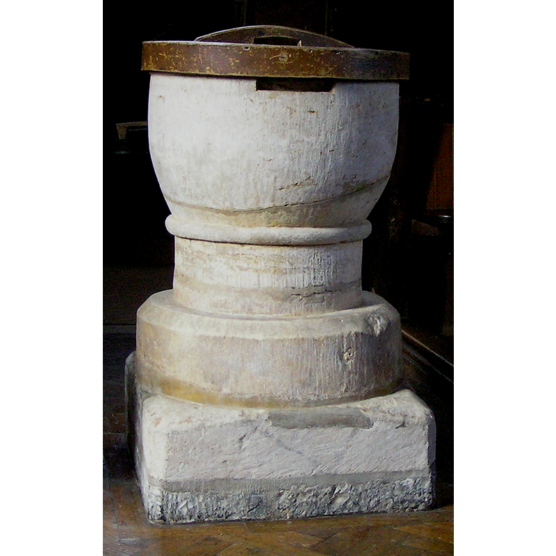
Image copyright © Tony Ethridge, 2009
Standing permission
Results: 4 records
view of font and cover
Copyright Statement: Image copyright © Tony Ethridge, 2009
Image Source: detail of a digital photograph taken 16 July 2008 by Tony Ethridge
Copyright Instructions: Standing permission
view of church exterior in context - south view
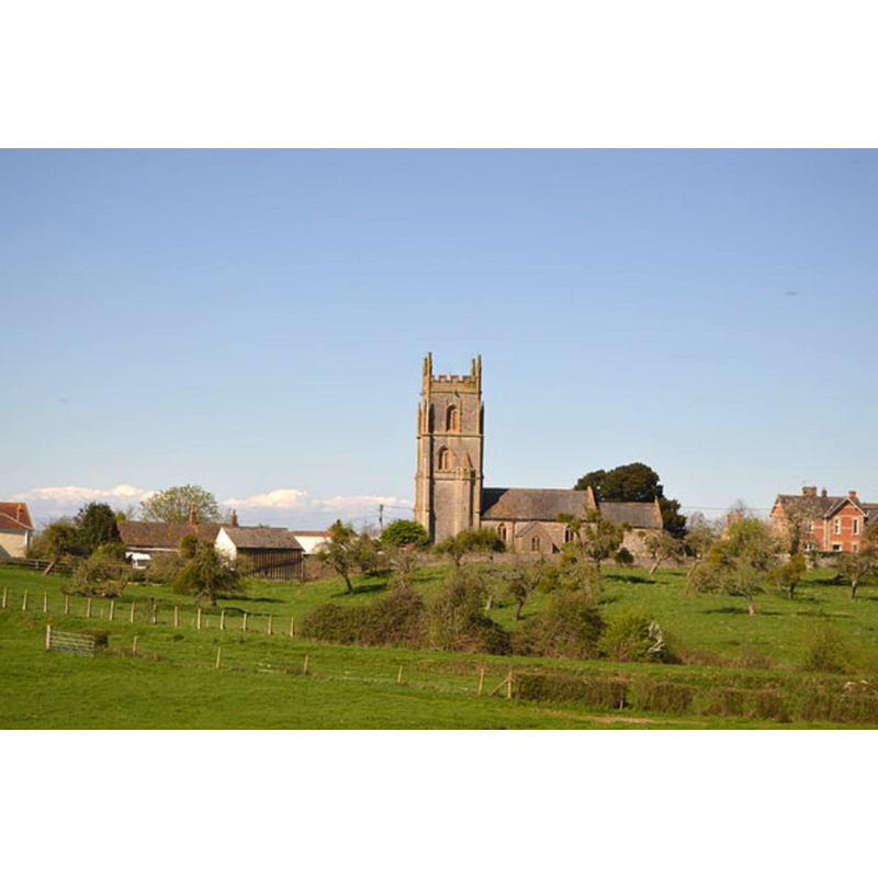
Copyright Statement: Image copyright © N Chadwick, 2017
Image Source: digital photograph taken 2 April 2017 by N Chadwick [www.geograph.org.uk/photo/5552166] [accessed 3 April 20018]
Copyright Instructions: CC-BY-SA-2.0
view of font and cover in context
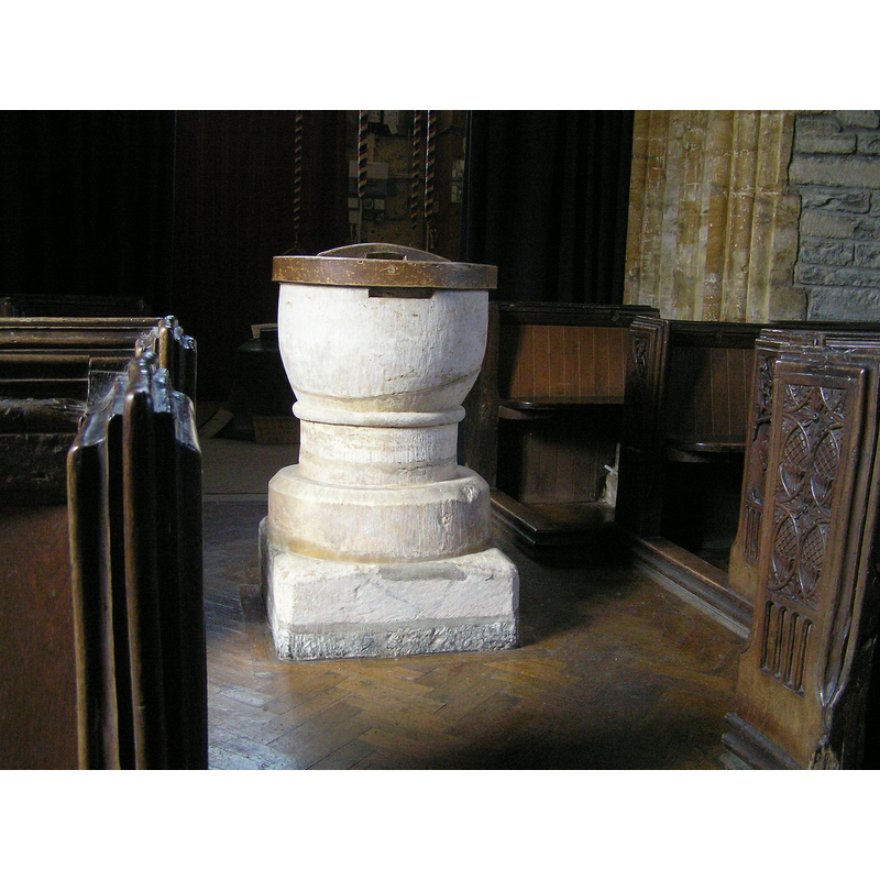
Copyright Statement: Image copyright © Tony Ethridge, 2009
Image Source: digital photograph taken 16 July 2008 by Tony Ethridge
Copyright Instructions: Standing permission
design element - motifs - roll moulding
Copyright Statement: Image copyright © Tony Ethridge, 2009
Image Source: detail of a digital photograph taken 16 July 2008 by Tony Ethridge
Copyright Instructions: Standing permission
INFORMATION
Font ID: 13451LYN
Object Type: Baptismal Font1
Font Century and Period/Style: 12th century, Late Norman
Church / Chapel Name: Parish Church of St. Bartholomew
Font Location in Church: Inside the church, at the W end of the nave
Church Patron Saint(s): St. Bartholomew
Church Address: Main Road, Lyng, TA3 5AU Somerset, UK
Site Location: Somerset, South West, England, United Kingdom
Directions to Site: Located of (S) the A361, 11 km ENE of Taunton
Ecclesiastic Region: Diocese of Bath & Wells
Historical Region: Hundred of Andersfield -- Hundred of North Petherton [in Domesday]
Font Notes:
Click to view
There is an entry for this Lyng [variamt spelling] in the Domesday survey [http://opendomesday.org/place/ST3328/lyng/] [accessed 3 April 2018], but there is no mention of cleric or church in it although the place was in the lordship of the abbey of Athelney. Jeboult (1873) writes: "The font is exceedingly rude, and looks very ancient." Wade & Wade (1929) report a "tub font" in this church. The entry for this parish in the Victoria County History (Somerset, vol. 6, 1992) notes: "Lyng church, standing on the defences of the Saxon burh of East Lyng, [...] was described as a chapel in 1291, [...] presumably dependent upon the monastic church of Athelney [...] The plain font is of the 12th century". The entry for this church in the CRSBI (2018) notes: "The only Romanesque feature is the plain font [...] Located at the W end of the nave, in the central aisle, forward of the tower arch, a Norman tub, in hamstone or similar, although the superficial whiteness may be evidence of it having been painted at some time. The bowl is supported on a shallow cylindrical stem, and this on a base with a plinth below. The bowl is of the usual tub form. There is a strong torus roll running round the rim. The lead lining reaches across nearly half the rim. There is evidence of lock fittings on the W and E sides of the rim. Also in the rim, on the N side, there is a repair from some other fitting. The surface is vertically tooled, and the internal sides curve slightly at their base into the usual dished bottom. The stem is a relatively shallow cylinder apparently in two blocks, and between stem and bowl is a narrow roll. The base of the font is basically circular but has been cut back almost flush to the stem on the W side. The top of the base is chamfered but there is a substantial shelf between the top of the chamfer & the bottom of the stem of the font. The plinth underneath the font is a substantial block apparently of blue lias in two levels, but the extension to the W (for the priest’s platform) conforms in height with the lower of the two levels. The surface of the W extension has been neatly tooled with a broad instrument. The top surface of the main block has been worn or roughly chamfered in parts." The font consists of a plain tub-shaped basin that is badly cracked/broken through at the botom, raised on a cylindrical stem that has a roll moulding at the top, and circular lower base chamfered at the top; there is a quadrangular lower volume serving as plinth. The wooden cover is round and plain, with a long wooden handle. Not mentioned in Pevsner (1958).
Credit and Acknowledgements: We are grateful to Tony Ethridge, of Somerset Villages, for his photograph of this font
COORDINATES
UTM: 30U 503192 5655902
Latitude & Longitude (Decimal): 51.05464, -2.95446
Latitude & Longitude (DMS): 51° 3′ 16.7″ N, 2° 57′ 16.06″ W
MEDIUM AND MEASUREMENTS
Material: stone
Font Shape: tub-shaped, mounted
Basin Interior Shape: round
Basin Exterior Shape: round
Rim Thickness: 8.5 cm [calculated]
Diameter (inside rim): 48 cm*
Diameter (includes rim): 65 cm*
Basin Depth: 28 cm*
Basin Total Height: 43 cm*
Height of Base: 20 cm*
Font Height (with Plinth): 107 cm * [plinth = 16 cm*]
Notes on Measurements: * CRSBI (2016)
LID INFORMATION
Material: wood
Apparatus: no
Notes: [cf. FontNotes]
REFERENCES
- Victoria County History [online], University of London, 1993-. URL: https://www.british-history.ac.uk.
- Corpus of Romanesque Sculpture in Britain and Ireland, The Corpus of Romanesque Sculpture in Britain and Ireland, The Corpus of Romanesque Sculpture in Britain and Ireland. URL: http://www.crsbi.ac.uk.
- Jeboult, Edward, A General Account of West Somerset, description of the Valley of the Tone, and the history of the twon of Taunton, Taunton: Somerset and Bristol Steam-press, 1873, p. 61 / [http://books.google.ca/books?id=h-kGAAAAYAAJ&pg=RA1-PA100&lpg=RA1-PA100&dq=west+hatch+church+font&source=bl&ots=8DPeBrOd_W&sig=MBiQ5MYBqifsAD89-vQ_wGSHaKA&hl=en&ei=woMRSv6yH4jOMqKBnbMG&sa=X&oi=book_result&ct=result&resnum=1#PPP7,M1] [accessed 18 May 2009]
- Wade, G.H., Somerset, London: Methurn & Co., 1929, [http://www.gutenberg.org/files/12287/12287-h/12287-h.htm] [accessed 26 March 2008]