Keinton Mandeville / Chintone / Chintune
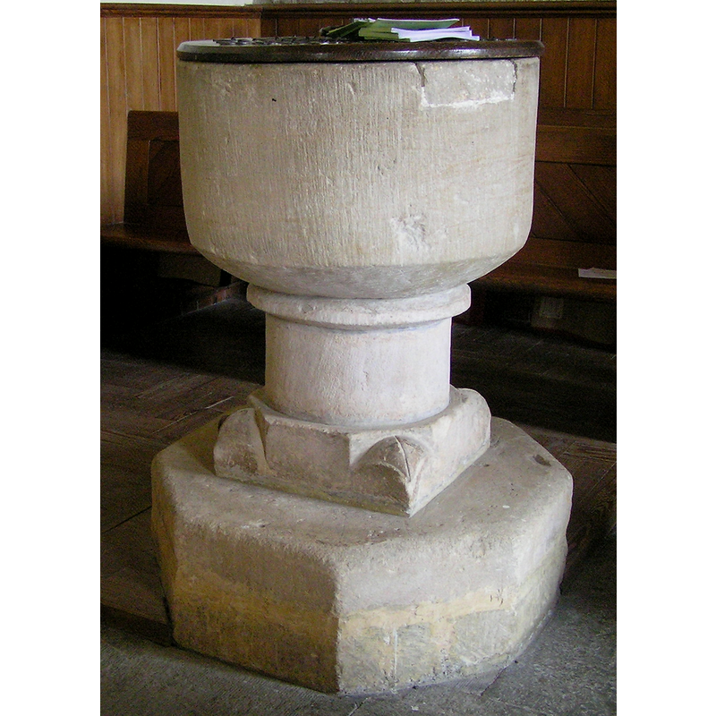
Image copyright © Tony Ethridge, 2009
Standing permission
Results: 5 records
view of font and cover
Copyright Statement: Image copyright © Tony Ethridge, 2009
Image Source: detail of a digital photograph taken 5 March 2009 by Tony Ethridge
Copyright Instructions: Standing permission
view of church exterior - southwest view
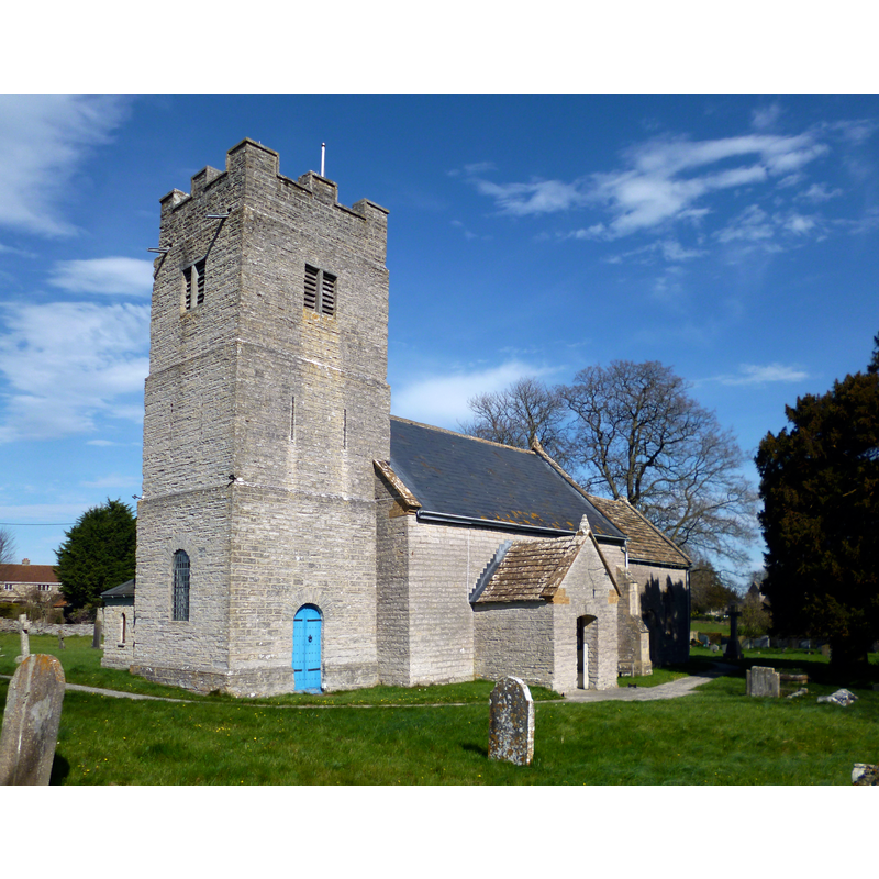
Copyright Statement: Image copyright © Dave Kelly, 2014
Image Source: digital photograph taken 15 March 2014 by Dave Kelly [www.geograph.org.uk/photo/3889324] [accessed 31 January 2018]
Copyright Instructions: CC-BY-SA-2.0
view of font and cover in context
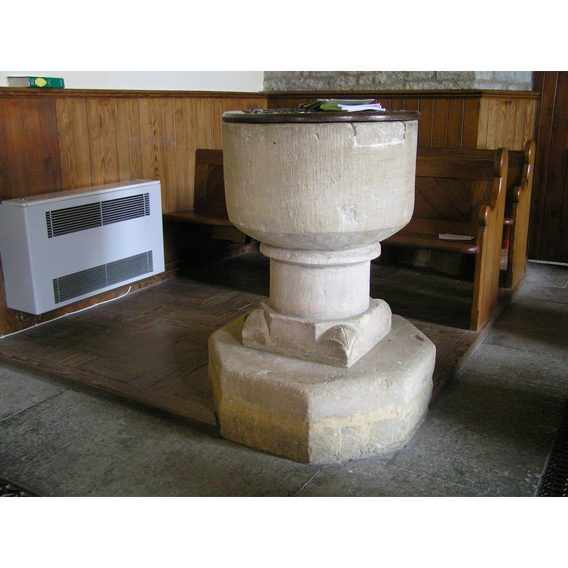
Copyright Statement: Image copyright © Tony Ethridge, 2009
Image Source: digital photograph taken 5 March 2009 by Tony Ethridge
Copyright Instructions: Standing permission
design element - motifs - spur - 4
![[cf. Font notes]](/static-50478a99ec6f36a15d6234548c59f63da52304e5/compressed/1090529007_compressed.png)
Scene Description: [cf. Font notes]
Copyright Statement: Image copyright © Tony Ethridge, 2009
Image Source: detail of a digital photograph taken 5 March 2009 by Tony Ethridge
Copyright Instructions: Standing permission
design element - motifs - moulding
Copyright Statement: Image copyright © Tony Ethridge, 2009
Image Source: detail of a digital photograph taken 5 March 2009 by Tony Ethridge
Copyright Instructions: Standing permission
INFORMATION
Font ID: 13436KEI
Object Type: Baptismal Font1
Font Century and Period/Style: 12th - 13th century, Medieval
Church / Chapel Name: Parish Church of St. Mary Magdalene
Font Location in Church: Inside the church, at the W end of the nave, S side
Church Patron Saint(s): St. Mary Magdalene
Church Address: Church Lane, Keinton Mandeville TA11 6ER, UK -- Tel.: (01458) 223237
Site Location: Somerset, South West, England, United Kingdom
Directions to Site: Located off the B3153, near Barton St David, 10 km W of Castle Cary, SE of Street
Ecclesiastic Region: Diocese of Bath & Wells
Historical Region: Hundred of Blachethorna
Additional Comments: damaged font / repaired font
Font Notes:
Click to view
There are two entries for Keinton [Mandeville] [variant spelling] in the Domesday survey [http://opendomesday.org/place/ST5430/keinton-mandeville/] [accessed 31 January 2018], neither of which mentions cleric or church in it. Kelly's Directory of 1883 reports: "font in the Early English style". Wade & Wade (1929) report that "the old Norm[an] font is still preserved" in this church. Baptismal font consisting of a plain cylindrical basin with a rounded underbowl, all plain, raised on a cylindrical stem with a moulding at the top end; the lower base is octagonal-to-square, with large rounded spurs at 90-degree angles; the upper rim of the basin has a repair of inserted stone. The wooden cover is round and flat; appears modern. Not mentioned in Pevsner (1958). The entry for this church in Images of England [www.imagesofengland.org.uk/Details/Default.aspx?id=262896] [accessed 31 January 2018] reports: "Font may be C13". The Victoria County History (Somerset, vol. 10, 2011) notes: "The church is first mentioned in 1242–3, [...] and the lancets in the chancel suggest a foundation in the earlier 13th century [...] The medieval church, which was 54 ft long but only 18 ft wide, had a simple nave and chancel of the 13th century. Both survive together with a simple font, probably, of the 12th century".
Credit and Acknowledgements: We are grateful to Tony Ethridge, of Somerset Villages, for his photograph of this font
COORDINATES
UTM: 30U 524702 5657476
Latitude & Longitude (Decimal): 51.068274, -2.647446
Latitude & Longitude (DMS): 51° 4′ 5.78″ N, 2° 38′ 50.81″ W
MEDIUM AND MEASUREMENTS
Material: stone
Font Shape: cylindrical, mounted
Basin Interior Shape: round
Basin Exterior Shape: round
LID INFORMATION
Date: modern?
Material: wood
Apparatus: no
Notes: [cf. FontNotes]
REFERENCES
- Victoria County History [online], University of London, 1993-. URL: https://www.british-history.ac.uk.
- Kelly, Eric Robert, Kelly's Directory of Somersetshire with the city of Bristol, London: Kelly & Co., 1883, p. 238
- Wade, G.H., Somerset, London: Methurn & Co., 1929, [http://www.gutenberg.org/files/12287/12287-h/12287-h.htm] [accessed 16 March 2008]