Taynton nr. Newent / Tetinton
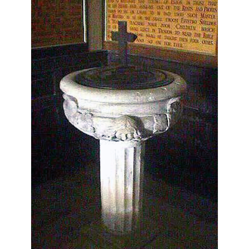
Image copyright © John Wilkes, 2008
Standing permission
Results: 6 records
view of font and cover
Copyright Statement: Image copyright © John Wilkes, 2008
Image Source: digital photograph by John Wilkes, in The Gloucestershire Photo Library [http://www.allthecotswolds.com/] [accessed 3 January 2008]
Copyright Instructions: Standing permission
design element - motifs - moulding
Scene Description: [cf. Font notes]
Copyright Statement: Image copyright © John Wilkes, 2008
Image Source: digital photograph by John Wilkes, in The Gloucestershire Photo Library [http://www.allthecotswolds.com/] [accessed 3 January 2008]
Copyright Instructions: Standing permission
angel - cherub
Scene Description: [cf. Font notes]
Copyright Statement: Image copyright © John Wilkes, 2008
Image Source: digital photograph by John Wilkes, in The Gloucestershire Photo Library [http://www.allthecotswolds.com/] [accessed 3 January 2008]
Copyright Instructions: Standing permission
design element - motifs - leaf - acanthus
Scene Description: [cf. Font notes]
Copyright Statement: Image copyright © John Wilkes, 2008
Image Source: digital photograph by John Wilkes, in The Gloucestershire Photo Library [http://www.allthecotswolds.com/] [accessed 3 January 2008]
Copyright Instructions: Standing permission
view of church exterior
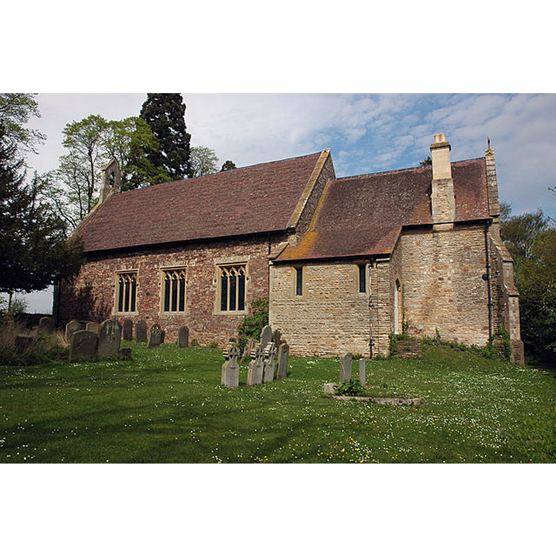
Scene Description: Source caption: "Taynton church is dedicated to St Lawrence. The church is unusual in that it was built during the Commonwealth, between 1650 and 1660. It replaced an earlier medieval church which was situated almost a mile to the north-east; this earlier church was destroyed in the English Civil War in 1643. The other unusual feature is that the church lies on a north/south orientation."
Copyright Statement: Image copyright © Philip Halling, 2007
Image Source: digital photograph taken 22 April 2007 by Philip Halling [www.geograph.org.uk/photo/435934] [accessed 10 December 2018]
Copyright Instructions: CC-BY-SA-2.0
design element - patterns - fluted
Scene Description: [cf. Font notes]
Copyright Statement: Image copyright © John Wilkes, 2008
Image Source: digital photograph by John Wilkes, in The Gloucestershire Photo Library [http://www.allthecotswolds.com/] [accessed 3 January 2008]
Copyright Instructions: Standing permission
INFORMATION
Font ID: 13297TAY
Object Type: Baptismal Font1
Font Century and Period/Style: 17th century(early?), Restoration
Church / Chapel Name: Parish Church of St. Lawrence
Font Location in Church: Inside the church
Church Patron Saint(s): St. Lawrence [aka Laurence]
Church Notes: Noted in The Gloucestershire Photo Library [http://www.allthecotswolds.com/] [accessed 3 January 2008], after Verey & Brooks (1999-2002) :"The ancient church on the site of St. Lawrence's was destroyed during the Civil War (1643). The new one was built by order of Parliament in 1647-8. It is a simple hall-church orientated north and south. It was restored by Thomas Fulljames in 1864, and the chancel added in 1894. It has a Restoration font with cherub-heads and acanthus-leaf"
Church Address: Taynton Rd, Taynton GL19 3AN, UK
Site Location: Gloucestershire, South West, England, United Kingdom
Directions to Site: Located off the B4215, N of the A40, 4 km S of Newent
Ecclesiastic Region: Diocese of Gloucester
Historical Region: Hundred of Botloe
Additional Comments: altered font? (the present font is mid-1thC, embelished in mid-19thC) -- disappeared font? (the original font from the medieval 11th-12thC(?) destroyed church)
Font Notes:
Click to view
There is an entry for this Taynton [variant spelling] in the Domesday survey [http://opendomesday.org/place/SO7321/taynton/] [accessed 10 December 2019] but it mentions neither cleric nor church in it. The entry for this parish in the Victoria County History (Gloucester, vol. 12, 2010) notes: "ieval parish church stood near Taynton's eastern boundary within earthworks probably raised first soon after the Norman Conquest for the lord of Great Taynton. [...] Its early history was evidently as a chapel of Newent church [...] The medieval church was burnt down [by Royalists] in 1643 and a new parish church was built on a more central site after a few years. [...] The font, one of the church's mid 17th-century fittings, has a bowl carved with cherubs' heads and acanthus and resting on a fluted pedestal. [...] In 1825 [...] the font was embellished." Verey & Brooks (1999-2002) note: "Font of c. 1660, a round bowl, with cherubs' heads and acanthus leaf, on a fluted stem.". The font consists of a round basin with marked lip moulding at the upper rim, the cherub heads on the lower basin and underbowl, while the acanthus leaves rise up to the rim moulding; it is raised on a slender fluted pedestal base. Round cover, almost flat, with a Latin cross finial/handle. The entry for the new church in Historic England [Listing NGR: SO7372622147] notes: "Parish church; 1650 for T. Pury, altered 1825, 1864 by T. Fulljames, 1893 (foundation stone to chancel). [...] Font: circular bowl with alternate cherubs' heads and acanthus leaves, fluted stem, on square base, up 2 stone steps." [NB: we have no information on the font from the original medieval church that was destroyed in 1643 during the Civil War; presumably the font disapeared at the same time]
Credit and Acknowledgements: We are grateful to John Wilkes, of The Gloucestershire Photo Library [www.allthecotswolds.com], for his photograph of this font.
COORDINATES
UTM: 30U 542438 5749784
Latitude & Longitude (Decimal): 51.8972, -2.38324
Latitude & Longitude (DMS): 51° 53′ 49.92″ N, 2° 22′ 59.66″ W
MEDIUM AND MEASUREMENTS
Material: stone
Font Shape: hemispheric, mounted
Basin Interior Shape: round
Basin Exterior Shape: round
LID INFORMATION
Apparatus: no
Notes: [cf. FontNotes]
REFERENCES
- Victoria County History [online], University of London, 1993-. URL: https://www.british-history.ac.uk.
- Verey, David, Gloucestershire, London: Penguin Books, 1999-2002, vol. 2: 706