Tirley
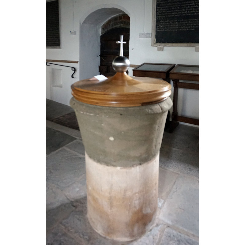
Image copyright © Ian S, 2016
CC-BY-SA-2.0
Results: 6 records
view of font and cover
Copyright Statement: Image copyright © Ian S, 2016
Image Source: digital photograph taken 26 May 2016 by Ian S [www.geograph.org.uk/photo/4976825] [accessed 1 February 2019]
Copyright Instructions: CC-BY-SA-2.0
view of church exterior - northeast view
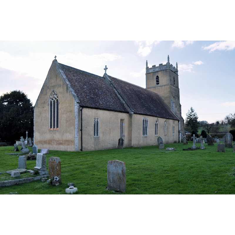
Scene Description: Source caption: "The much-flooded Tirley church, built on a slight platform above the riverside meadows. This is often sufficient to repel the waters, but in 2007 the sight of the church completely surrounded by deep floodwater made headlines around the world."
Copyright Statement: Image copyright © Philip Pankhurst, 2014
Image Source: digital photograph taken 18 November 2014 by Philip Pankhurst [www.geograph.org.uk/photo/4291068] [accessed 1 February 2019]
Copyright Instructions: CC-BY-SA-2.0
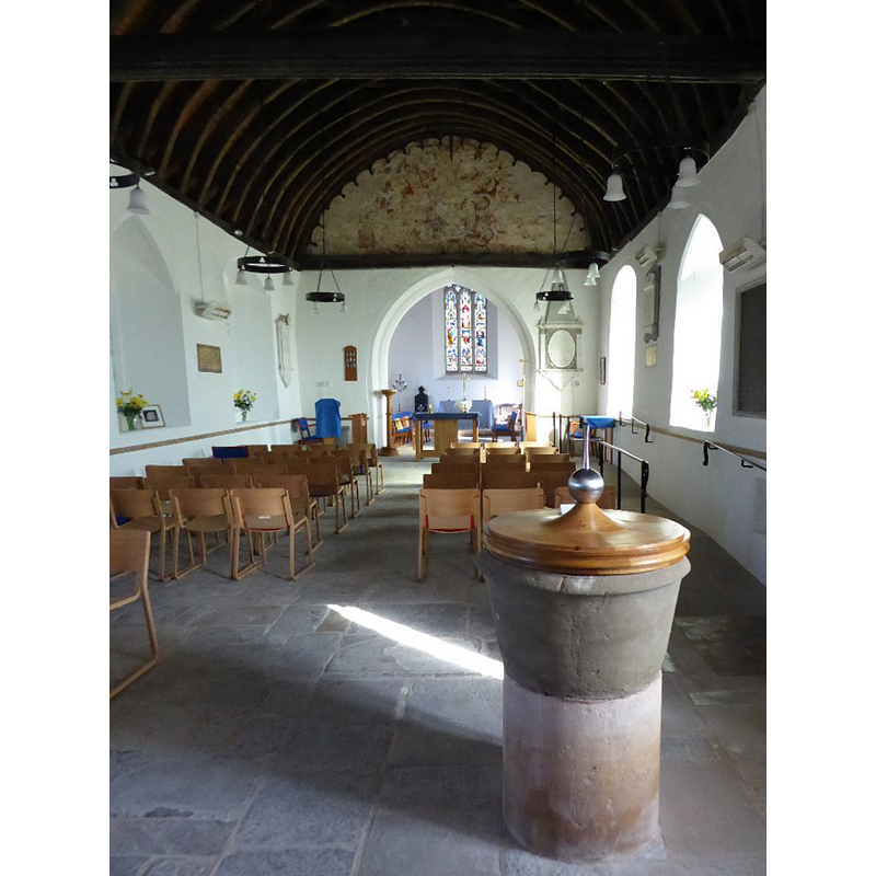
view of font and cover in context
Scene Description: Source caption: "St. Michael's church, Tirley, interior looking west. The floods of 2007 resulted in a complete refurbishment of the church with mostly new furnishings."
Copyright Statement: Image copyright © Jonathan Thacker, 2018
Image Source: digital photograph taken 23 June 2018 by Jonathan Thacker [www.geograph.org.uk/photo/5858431] [accessed 1 Fabruary 2019]
Copyright Instructions: CC-BY-SA-2.0
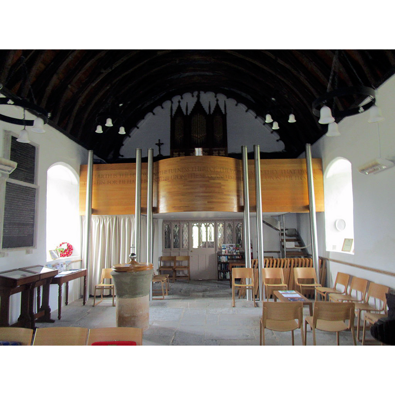
view of church interior - nave - looking west

Scene Description: Source caption: "View to the west along the nave of Tirley church. Until the devastating flood of July 2007 there were pews in the nave however five feet of water resulted in a mature restoration."
Copyright Statement: Image copyright © Philip Halling, 2017
Image Source: digital photograph taken 25 March 2017 by Philip Halling [www.geograph.org.uk/photo/5326119] [accessed 1 February 2019]
Copyright Instructions: CC-BY-SA-2.0
view of font and cover in context
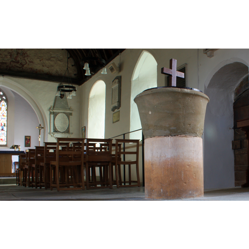
Scene Description: the font in the nave, by the south entranceway -- Source caption: "The font, Tirley church. Very old, Saxon or Norman, made from two Cotswold stones; the upper one being lead lined."
Copyright Statement: Image copyright © Bob Embleton, 2011
Image Source: digital photograph taken by 14 July 2011 by Bob Embleton [www.geograph.org.uk/photo/2505906] [accessed 1 February 2019]
Copyright Instructions: CC-BY-SA-2.0
view of church interior - nave - looking east
Scene Description: with the font and cover in the foreground, south side -- Source caption: "The interior of Tirley church. In July 2007 Tirley church was hit by a devastating flood with water five feet deep in the nave of the church. Since then much restoration work has been carried out to the church, the most obvious change being the removal of the pews."
Copyright Statement: Image copyright © Philip Halling, 2017
Image Source: digital photograph taken 25 March 2017 by Philip Halling [www.geograph.org.uk/photo/5325215] [accessed 1 February 2019]
Copyright Instructions: CC-BY-SA-2.0
INFORMATION
Font ID: 13291TIR
Object Type: Baptismal Font1
Font Century and Period/Style: 12th century, Late Norman? / Transitional?
Church / Chapel Name: Parish Church of St. Michael and All Angels [formerly St. Matthew's]
Font Location in Church: Inside the church, by the S entranceway
Church Patron Saint(s): St. Michael & All Angels [earlier dedicated to St. Matthew?]
Church Address: Church Road, Tirley, Gloucestershire, GL19 4HH
Site Location: Gloucestershire, South West, England, United Kingdom
Directions to Site: Located on the A4213, 6 km S of Tewkesbury, 12 km N of Gloucester
Ecclesiastic Region: Diocese of Gloucester
Historical Region: Hundred of Deerhurst
Additional Comments: altered font: re-cut?
Font Notes:
Click to view
No entry found for Tirley in the Domesday survey. The entry for this parish in the Victoria County History (Gloucester, vol. 8, 1968) notes: "There is likely to have been a church or chapel of ease in Tirley c. 1220 [...] The plan of the church, together with the tower and one of the south windows of the nave, [...] survives from the 14th century. [...] The font is tubshaped and plain, apparently of the 12th or 13th century". The entry for this church in Historic England [Listing NGR: SO8401128558] notes: "Anglican parish church. C13, C14, Perpendicular restored 1894. [...] C12 tub font inside south door." Noted in Verey & Brooks (1999-2002). "Scraped font, possibly Norman, a tapering tub on cylindrical stem" [NB: the present shape of the font suggests it may have been re-cut, or re-tooled, at some point, which would account for the unlikely lip moulding at the upper rim and the slender shape it now bears].
Credit and Acknowledgements: We are grateful to John Wilkes, of The Gloucestershire Photo Library, for the photographs of this church and font.
COORDINATES
UTM: 30U 552623 5756283
Latitude & Longitude (Decimal): 51.954755, -2.234232
Latitude & Longitude (DMS): 51° 57′ 17.12″ N, 2° 14′ 3.23″ W
MEDIUM AND MEASUREMENTS
Material: stone
Font Shape: tub-shaped
Basin Interior Shape: round
Basin Exterior Shape: round
Drainage Notes: lead-lined
LID INFORMATION
Material: wood
Apparatus: no
Notes: flat and round, with Latin cross finial/handle; appears modern
REFERENCES
- Victoria County History [online], University of London, 1993-. URL: https://www.british-history.ac.uk.
- Verey, David, Gloucestershire, London: Penguin Books, 1999-2002, vol. 2: 764