Waterbeach / Utbech
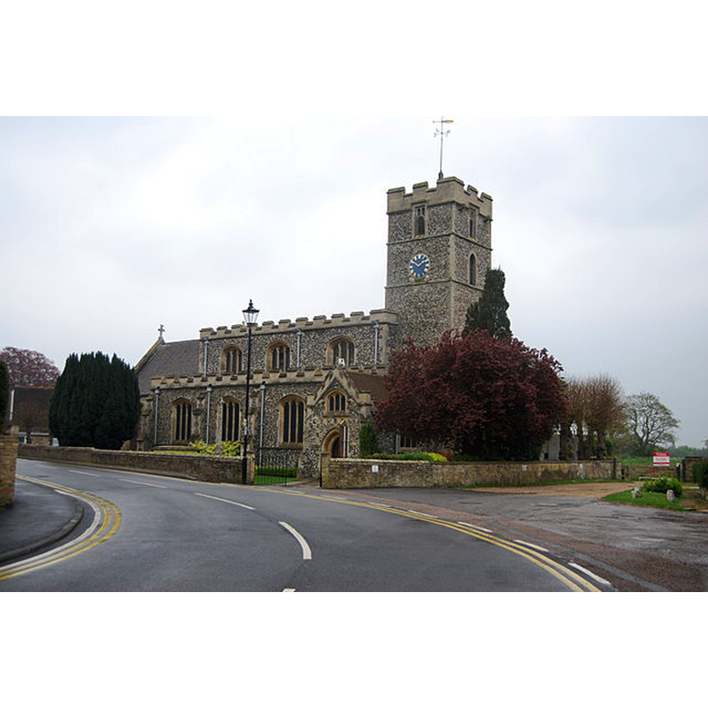
Image copyright © N Chadwick, 2014
CC-BY-SA-2.0
Results: 3 records
view of church exterior - northwest view
Copyright Statement: Image copyright © N Chadwick, 2014
Image Source: digital photograph taken 20 April 2014 by N Chadwick [www.geograph.org.uk/photo/4052668] [accessed 30 June 2016]
Copyright Instructions: CC-BY-SA-2.0
view of church interior - nave - looking east
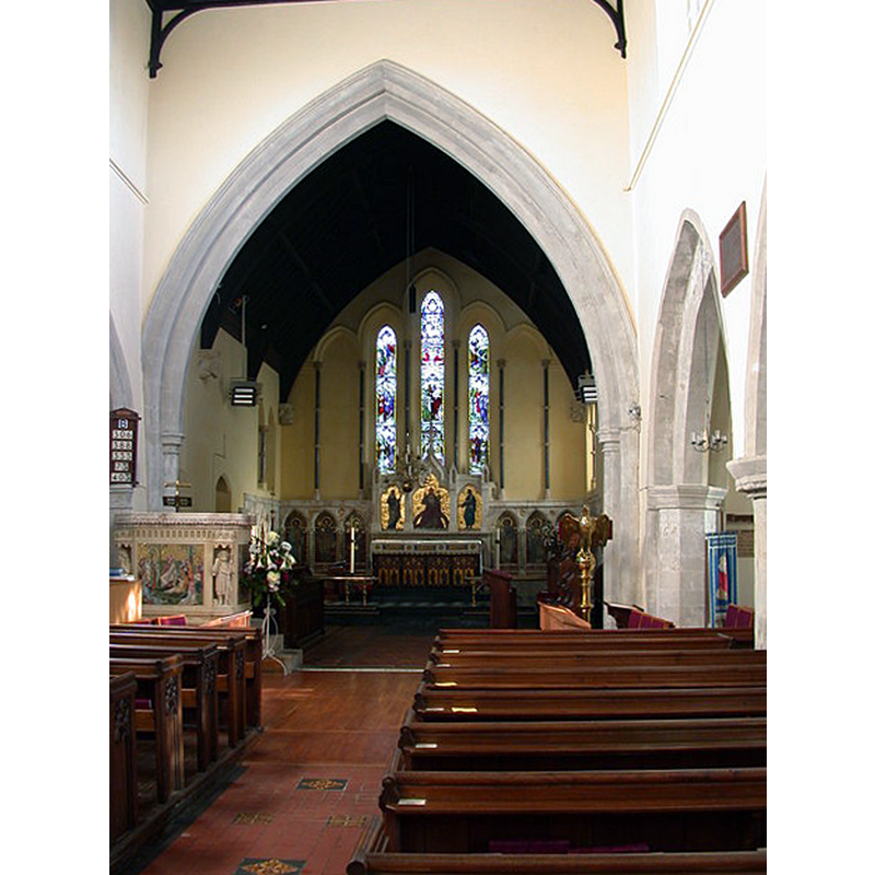
Copyright Statement: Image copyright © Keith Edkins, 2008
Image Source: digital photograph taken 30 January 2008 by Keith Edkins [www.geograph.org.uk/photo/673413] [accessed 30 June 2016]
Copyright Instructions: CC-BY-SA-2.0
view of basin - detail
![detail of the new font [cf. Font notes]](/static-50478a99ec6f36a15d6234548c59f63da52304e5/compressed/1071009001_compressed.png)
Scene Description: detail of the new font [cf. Font notes]
Copyright Statement: Image copyright © Mark Ynys-Mon, 2007
Image Source: digital photograph by Mark Ynys-Mon in Cambridgeshire Churches [http://www.druidic.org/camchurch/churches/kingston.htm] [accessed 11 October 2007]
Copyright Instructions: Standing permission
INFORMATION
Font ID: 13172WAT
Object Type: Baptismal Font1
Font Century and Period/Style: 13th century, Early English
Church / Chapel Name: Parish Church of St. John the Evangelist
Font Location in Church: [cf. FontNotes]
Church Patron Saint(s): St. John the Evangelist
Church Address: 11 Station Road, Waterbeach, Cambridgeshire CB5 9HT
Site Location: Cambridgeshire, East, England, United Kingdom
Directions to Site: Located off (E) the A10, 9 km NNE of Cambridge
Ecclesiastic Region: Diocese of Ely
Historical Region: Hundred of Northstowe
Additional Comments: disappeared font? (the one of the 12thC church here)
Font Notes:
Click to view
There are two entries for Waterbeach [variant spelling] in the Domesday survey [http://opendomesday.org/place/TL4965/waterbeach/] [accessed 30 June 2016], neither of which mentions cleric or church in it. Paley's Guide (1844) reports: "The font is plain octagonal Early-English". The National Gazeteer of Great Britain and Ireland (1868) reports an "antique font" in this church at the time. Kelly's Directory of this county for 1929 notes "the beautiful font of marble and Caen stone", obviously a different one. The Victoria County History (Cambridge and Isle of Ely, vol. 9, 1989) notes: "A church at Waterbeach had been founded by c. 1160, when priests were recorded there. […] The earliest surviving part of the church is probably the two eastern bays of the nave, which have poorly set out and plainly chamfered arches on piers of clunch, mostly octagonal, without bases, one with a carved late 12th-century capital. The arches to the south are perhaps slightly older than those to the north. They were all possibly cut through the thick walls of an earlier church. […] A plain octagonal font, probably 13th-century, in place until 1880, was probably then taken to the Fen church, where portions of the old square wooden pulpit, whose carved panels were described c. 1870 as Decorated, were re-used in a reading desk. Both were brought back to the village after 1964. […] mosaic panels by Powell of Whitefriars adorned the square alabaster pulpit, inaugurated in 1883 with a new font on marble shafts."
, describes a new font, probably the one mentioned in Kelly: "A plain octagonal font, probably 13th-century, in place until 1880, was probably then taken to the Fen church" [NB: two 'Fen' churches in Cambridgeshire: Fen Ditton, nearby, and Fen Drayton, nearer Huntingdon -- the font at Fen Ditton is of later date and decorated -- the one at Fen Drayton is listed in Cox & Harvey as being from the Decorated period, i.e., 14th-century]. A '"new font on marble shafts", dating from the late-19th century renovations is also noted in the VCH entry [cf. supra]. The later font is described and illustrated in Cambridgeshire Churches (2004) [http://www.druidic.org/camchurch/churches/waterbeach.htm] [accessed 9 October 2007]: "the font is a confection of enamel, mosaic, topped with marble tracery. Quite ridiculous, but rather fun."
, describes a new font, probably the one mentioned in Kelly: "A plain octagonal font, probably 13th-century, in place until 1880, was probably then taken to the Fen church" [NB: two 'Fen' churches in Cambridgeshire: Fen Ditton, nearby, and Fen Drayton, nearer Huntingdon -- the font at Fen Ditton is of later date and decorated -- the one at Fen Drayton is listed in Cox & Harvey as being from the Decorated period, i.e., 14th-century]. A '"new font on marble shafts", dating from the late-19th century renovations is also noted in the VCH entry [cf. supra]. The later font is described and illustrated in Cambridgeshire Churches (2004) [http://www.druidic.org/camchurch/churches/waterbeach.htm] [accessed 9 October 2007]: "the font is a confection of enamel, mosaic, topped with marble tracery. Quite ridiculous, but rather fun."
Credit and Acknowledgements: We are grateful to Ben Colburn and Mark Ynys-Mon, of www.druidic.org/camchurches for the photograph of the modern font.
COORDINATES
UTM: 31U 308453 5794048
Latitude & Longitude (Decimal): 52.263408, 0.193035
Latitude & Longitude (DMS): 52° 15′ 48.27″ N, 0° 11′ 34.93″ E
MEDIUM AND MEASUREMENTS
Material: stone
Font Shape: octagonal, mounted
Basin Interior Shape: round
Basin Exterior Shape: octagonal
REFERENCES
- The National Gazetteer: a Topographical Dictionary of the British Isles, London: Virtue & Co., 1868, [transcription by Colin Hinson in www.genuki.org.uk/big/eng/CAM/Waterbeach/ [accessed 30 June 2016]]
- Victoria County History [online], University of London, 1993-. URL: https://www.british-history.ac.uk.
- Kelly, Kelly's Directory of Cambridgeshire, London: Kelly's Directories Ltd., 1929, [www.genuki.org.uk/big/eng/CAM/Waterbeach/] [accessed 9 October 2007]
- Paley, Frederick Apthorp, The Ecclesiologist's guide to the churches within a circuit of seven miles round Cambridge, with introductory remarks, London; Cambridge: J. van Voorst; Metcalfe and Palmer, 1844, p. 6