Garthorpe / Gerulftorp
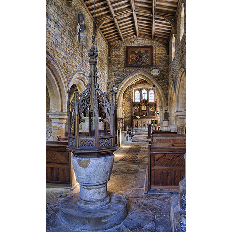
Image copyright © Christopher Jones, 2015
Standing permission
Results: 2 records
view of font and cover in context
Copyright Statement: Image copyright © Christopher Jones, 2015
Image Source: digital photograph taken by Christopher Jones [www.leicestershirechurches.co.uk/garthorpe-church-st-marys/] [accessed 11 August 2015]
Copyright Instructions: Standing permission
view of church exterior - south view
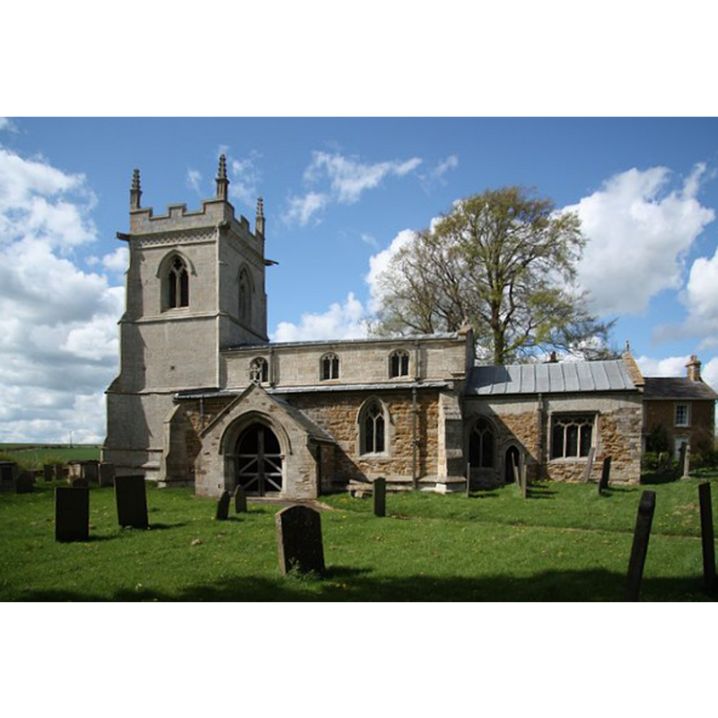
Scene Description: Source caption: "St.Mary's church. Redundant parish church at Garthorpe. Some early 13th century features inside but essentially a 14th century ironstone church with 15th century grey limestone additions."
Copyright Statement: Image copyright © Richard Croft, 2009
Image Source: digital photograph taken 25 April 2009 by Richard Croft [www.geograph.org.uk/photo/1276827] [accessed 11 August 2015]
Copyright Instructions: CC-BY-SA-2.0
INFORMATION
Font ID: 13130GAR
Object Type: Baptismal Font1
Font Century and Period/Style: 17th century, Post-Reformation
Church / Chapel Name: Parish Church of St. Mary [redundant]
Font Location in Church: Inside the church, at the W end of the nave
Church Patron Saint(s): St. Mary the Virgin
Church Notes: original fabric of this church early-13thC; restored 1895-1896
Church Address: Garthorpe, Leicestershire LE14 2RS
Site Location: Leicestershire, East Midlands, England, United Kingdom
Directions to Site: Located on the B676, 8 km E of Melton Mowbray
Ecclesiastic Region: Diocese of Leicester
Additional Comments: disappeared font? (the one from the 13thC church here)
Font Notes:
Click to view
No entry for this Garthorpe found in the Domesday survey. A font here is noted and illustrated in Upcott (1818). The present font is bucket-shaped, said to be of the 17th-century; it consists of a bucket-shaped basin raised on a short cylindrical pedestal base and a modern circular plinth; the basin and base are almost plain, just a round moulding on each; the basin looks battered and weathered, with a number of cement patches. The wooden cover is octagonal and tallish, much of it openwork on oak, with a floriated finial; appears Vitorian but could be earlier. [A north arcade indicates the church may go back to late Norman times, but most of the church is 14th or 15th century -- we have no information on the font of the original Norman church]
Credit and Acknowledgements: We are grateful to Christopher Jones, of Leicestershire Churches [www.leicestershirechurches.co.uk], for his photographs of this font
COORDINATES
UTM: 30U 650501 5850088
Latitude & Longitude (Decimal): 52.7796, -0.7686
Latitude & Longitude (DMS): 52° 46′ 46.56″ N, 0° 46′ 6.96″ W
MEDIUM AND MEASUREMENTS
Material: stone
Font Shape: bucket-shaped, mounted
Basin Interior Shape: round
Basin Exterior Shape: round
LID INFORMATION
Date: 19th-century?
Material: wood, oak?
Apparatus: yes; couterweight
Notes: [cf. FontNotes]
REFERENCES
- Upcott, William, A bibliographical account of the principal works relating to English topography, London: Printed by Richard and Arthur Taylor, 1818, p. 495 and pl. xxix, fig. 4