Frocester / Frowecestre
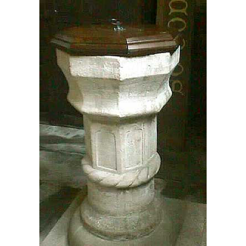
Image copyright © John Wilkes, 2007
Standing permission
Results: 6 records
view of font and cover
Scene Description: [cf. FontNotes]
Copyright Statement: Image copyright © John Wilkes, 2007
Image Source: digital photograph by John Wilkes, 2007 [www.allthecotswolds.com]
Copyright Instructions: Standing permission
design element - motifs - rope moulding
Copyright Statement: Image copyright © John Wilkes, 2007
Image Source: digital photograph by John Wilkes, 2007 [www.allthecotswolds.com]
Copyright Instructions: Standing permission
design element - architectural - arcade - blind
Copyright Statement: Image copyright © John Wilkes, 2007
Image Source: digital photograph by John Wilkes, 2007 [www.allthecotswolds.com]
Copyright Instructions: Standing permission
view of church exterior - tower
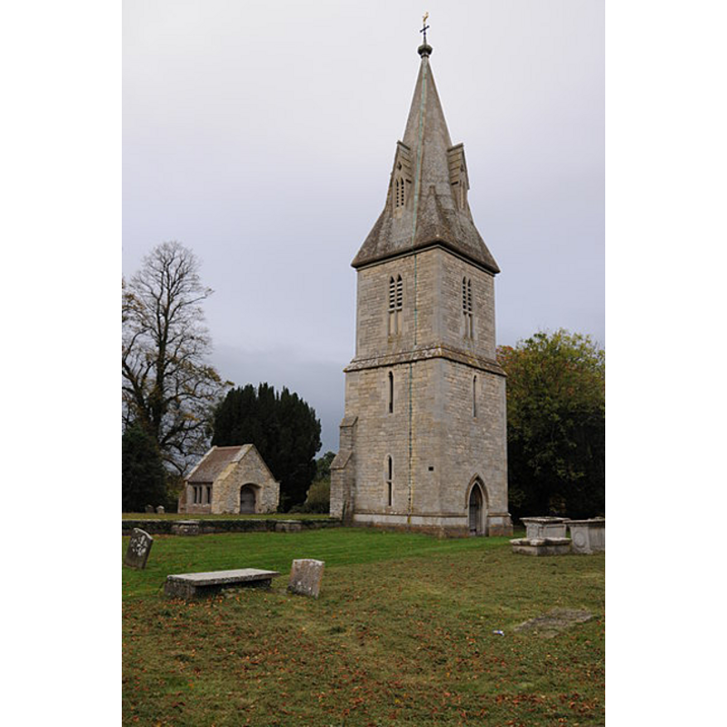
Scene Description: the rremains of the mid-19th century re-building of St. Peter's church; the rest was demolished in 1952
Copyright Statement: Image copyright © Philip Halling, 2011
Image Source: digital photograph taken 29 October 2011 by Philip Halling [www.geograph.org.uk/photo/2673699] [accessed 26 July 2012]
Copyright Instructions: CC-BY-SA-3.0
view of church exterior - south view
![the former chapel of St. Andrew [cf. FontNotes]](/static-50478a99ec6f36a15d6234548c59f63da52304e5/compressed/1070916029_compressed.png)
Scene Description: the former chapel of St. Andrew [cf. FontNotes]
Copyright Statement: Image copyright © John Wilkes, 2007
Image Source: digital photograph by John Wilkes, 2007 [www.allthecotswolds.com]
Copyright Instructions: Standing permission
view of church interior - looking east
![[cf. FontNotes]](/static-50478a99ec6f36a15d6234548c59f63da52304e5/compressed/1070916030_compressed.png)
Scene Description: [cf. FontNotes]
Copyright Statement: Image copyright © John Wilkes, 2007
Image Source: digital photograph by John Wilkes, 2007 [www.allthecotswolds.com]
Copyright Instructions: Standing permission
INFORMATION
Font ID: 13103FRO
Object Type: Baptismal Font1
Font Century and Period/Style: 13th century [base only] -- 17th century(late?) [basin only] [composite font], Medieval [composite]
Church / Chapel Name: Parish Church of St. Andrew [formerly St. Andrew's Chapel -- cf. FontNotes]
Font Location in Church: Inside the church
Church Patron Saint(s): St. Andrew
Church Notes: NB: the older church of St Peter's, abandoned in the 17th century, may have had an earlier font
Church Address: Peter Street, Frocester, Gloucestershire, GL10 3TF
Site Location: Gloucestershire, South West, England, United Kingdom
Directions to Site: Located 6 km S of Stroud, 15 km S of Gloucester
Ecclesiastic Region: Diocese of Gloucester
Historical Region: Hundred of Whitstone - Hundred of Blachelaue [in Domesday]
Additional Comments: composite font / altered font -- disappeared fonts? (the original ones from the chapel and the parish church here)
Font Notes:
Click to view
There is an entry for Frocester [variant spelling] in the Domesday survey [https://opendomesday.org/place/SO7803/frocester/] [accessed 13 February 2019] but it mentions neither cleric nor church in it. The entry for this parish in the Victoria County History (Gloucester, vol. 10, 1972) notes: "A tradition, first recorded in the 16th century, that there was anciently a college of secular priests at Frocester [...] is given some support by the description of the church there as 'the old minster' in 1313. [...] The church was evidently of a fairly early foundation and once served a wider area than Frocester parish. When first found recorded c. 1150 it had parochial rights over Nympsfield [...] It was allowed to decay during the 18th and early 19th centuries [...] until 1849, when it was rebuilt"; the VCH entry adds: "The 17th-century font, with an octagonal bowl on a pedestal adorned with trefoilheaded niches, [...] is probably the one mentioned at the chapel in 1680." [NB: St. Andrew's chapel is noted in the VCH as "according to tradition it stood near Frocester Court", having been "built in the late 17th century but incorporated some materials from the chapel recorded from 1282, [...] including presumably the small Norman light in the north wall of the chancel". The VCH entry further notes that, from about 1691, "the chapel was used for almost all services; the parish church, used only for burials, fell into disrepair, and was in ruins in 1828."] A font is noted in Verey & Brooks (1999-2002): "Font. A composite piece. Octagonal Perp[endicular] Survival bowl and panelled pedestal, late C17, set on a short circular stem and base which are possibly C13." The baptismal font is odd-looking, its design contrived, a result of its composite nature: the basin has shallow plain sides and a concave tallish underbowl; the upper half of the stem is octagonal with shallow-relief arches, and a thick Norman-looking rope-moulding, separates it from the lower half which is round and plain; splaying moulded lower base. Octagonal wooden cover, quite thick, with ring handle; appears modern. [NB: we have no information on the earlier fonts of St. Peter's or St. Andrew's].
Credit and Acknowledgements: We are grateful to John Wilkes, of www.allthecotswolds.com, for the photographs of this church and font.
COORDINATES
UTM: 30U 547471 5730930
Latitude & Longitude (Decimal): 51.727281, -2.312684
Latitude & Longitude (DMS): 51° 43′ 38.21″ N, 2° 18′ 45.66″ W
MEDIUM AND MEASUREMENTS
Material: stone
Font Shape: octagonal, mounted
Basin Interior Shape: round
Basin Exterior Shape: octagonal
LID INFORMATION
Material: wood, oak
Apparatus: no
Notes: [cf. FontNotes]
REFERENCES
- Victoria County History [online], University of London, 1993-. URL: https://www.british-history.ac.uk.
- Verey, David, Gloucestershire, London: Penguin Books, 1999-2002, vol. 2: 386