Farmington / Thormarton / Thormerton
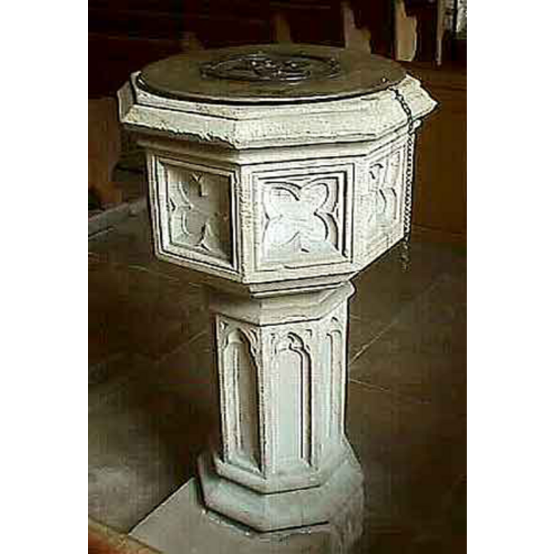
Image copyright © John Wilkes, 2007
Standing permission
Results: 8 records
view of font and cover
Scene Description: the modern font
Copyright Statement: Image copyright © John Wilkes, 2007
Image Source: digital photograph by John Wilkes, 2007 [www.allthecotswolds.com]
Copyright Instructions: Standing permission
design element - motifs - moulding - graded
Scene Description: the modern font
Copyright Statement: Image copyright © John Wilkes, 2007
Image Source: digital photograph by John Wilkes, 2007 [www.allthecotswolds.com]
Copyright Instructions: Standing permission
design element - motifs - quatrefoil - pointed or cusped quatrefoil - 8
Scene Description: the modern font
Copyright Statement: Image copyright © John Wilkes, 2007
Image Source: digital photograph by John Wilkes, 2007 [www.allthecotswolds.com]
Copyright Instructions: Standing permission
design element - motifs - moulding
Scene Description: the modern font
Copyright Statement: Image copyright © John Wilkes, 2007
Image Source: digital photograph by John Wilkes, 2007 [www.allthecotswolds.com]
Copyright Instructions: Standing permission
view of church exterior - southeast view
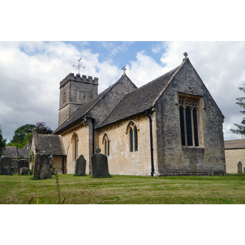
Copyright Statement: Image copyright © John Wilkes, 2017
Image Source: digital photograph taken 6 August 2017 by John Wilkes
Copyright Instructions: Standing permission
view of church interior - nave - looking east
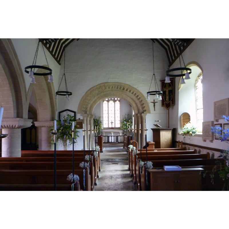
Copyright Statement: Image copyright © John Wilkes, 2017
Image Source: digital photograph taken 6 August 2017 by John Wilkes
Copyright Instructions: Standing permission
design element - motifs - moulding
Scene Description: the modern font
Copyright Statement: Image copyright © John Wilkes, 2007
Image Source: digital photograph by John Wilkes, 2007 [www.allthecotswolds.com]
Copyright Instructions: Standing permission
design element - architectural - arcade - blind - trefoiled arches or windows - 8
Scene Description: the modern font
Copyright Statement: Image copyright © John Wilkes, 2007
Image Source: digital photograph by John Wilkes, 2007 [www.allthecotswolds.com]
Copyright Instructions: Standing permission
INFORMATION
Font ID: 13101FAR
Object Type: Baptismal Font1, fragment
Font Century and Period/Style: 12th century, Norman
Church / Chapel Name: Parish Church of St. Peter
Font Location in Church: [cf. FontNotes]
Church Patron Saint(s): St. Peter
Church Address: Farmington, Gloucestershire, GL54 3ND
Site Location: Gloucestershire, South West, England, United Kingdom
Directions to Site: Located off (N) the A40, E of the A429, near Northleach, 20 km ESE of Cheltenham
Ecclesiastic Region: Diocese of Gloucester
Historical Region: Hundred of Bradley
Additional Comments: disused font? (Fragment buried and re-cycled as part of the ??)
Font Notes:
Click to view
There is an entry for Farmington in the Domesday survey [http://opendomesday.org/place/SP1315/farmington/] [accessed 6 August 2017]. The Victoria County History (Gloucester, vol. 9, 2001) notes: "The church at Farmington had, on architectural evidence, been built by the 12th century [...] a Gothick-style font installed in 1784"; this last reference is footnoted in the VCH: "Glos. R.O., P 143/IN ½, baptism 25 Nov. 1784. The bowl of a medieval font, used as a part of the 19th-cent. drainage system, was unearthed in the churchyard in the 1990s: Trans. B.G.A.S. cxviii. 223." [NB: we have not been able to locate the present whereabouts of the discovered basin fragment nor date it]. The present baptismal font consisting of an octagonal basin with a protruding upper rim moulding, the sides of the basin decorated with pointed-quatrefoil panels deeply carved; graded underbowl; trefoil windows/arches on the slender pedestal sides; moulded lower base. Flat round cover. Noted and illustrated in The Gloucestershire Photo Library. The modern font is noted in Verey & Brooks (1999-2002).
Credit and Acknowledgements: We are grateful to John Wilkes, of The Gloucestershire Photo Library [www.allthecotswolds.com], for the photographs of this church and modern font.
COORDINATES
UTM: 30U 582404 5743390
Latitude & Longitude (Decimal): 51.835247, -1.804029
Latitude & Longitude (DMS): 51° 50′ 6.89″ N, 1° 48′ 14.5″ W
MEDIUM AND MEASUREMENTS
Material: stone
Number of Pieces: fragment
LID INFORMATION
Apparatus: no
Notes: [cf. FontNotes]
REFERENCES
- Victoria County History [online], University of London, 1993-. URL: https://www.british-history.ac.uk.
- Verey, David, Gloucestershire, London: Penguin Books, 1999-2002