Finmere / Finemere / Finmore
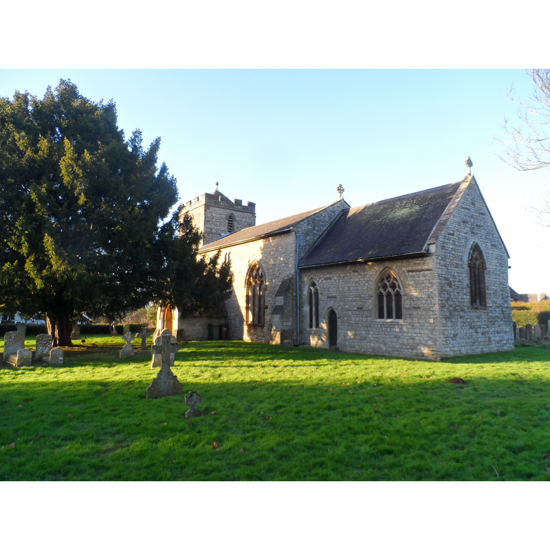
Image copyright © Bikeboy, 2015
CC-BY-SA-2.0
Results: 3 records
view of church exterior - southeast view
Scene Description: Source caption: "St Michael and All Angels, Finmere. Built in C14 and restored 1856-8 by George Edmund Street (1824-81)"
Copyright Statement: Image copyright © Bikeboy, 2015
Image Source: digital photograph taken 2 January 2015 by Bikeboy [www.geograph.org.uk/photo/4306221] [accessed 7 December 2016]
Copyright Instructions: CC-BY-SA-2.0
view of font

Scene Description: with a partial view of the Victorian cover, and of the lead lining -- the base is a modern replacement
Copyright Statement: Image copyright © The Corpus of Romanesque Sculpture in Britain and Ireland, 2016
Image Source: digital image of a photograph taken by Janet Newson, in the CRSBI [www.crsbi.ac.uk/site/3819/] [accessed 7 December 2016]
Copyright Instructions: PERMISSION NOT AVAILABLE -- IMAGE NOT FOR PUBLIC USE
design element - patterns - zigzag
Scene Description: lightly incised all around except where the damage was repaired with inserted stone
Copyright Statement: Image copyright © The Corpus of Romanesque Sculpture in Britain and Ireland, 2016
Image Source: digital image of a photograph taken by Janet Newson, in the CRSBI [www.crsbi.ac.uk/site/3819/] [accessed 7 December 2016]
Copyright Instructions: PERMISSION NOT AVAILABLE -- IMAGE NOT FOR PUBLIC USE
INFORMATION
Font ID: 13021FIN
Object Type: Baptismal Font1
Font Century and Period/Style: 12th century (late?) [basin only] [composite font], Medieval [composite]
Church / Chapel Name: Parish Church of St. Michael and All Angels
Font Location in Church: Inside the church, W end, N aisle, opposite the S doorway
Church Patron Saint(s): St. Michael & All Angels
Church Address: Valley Road, Finmere, Oxfordshire MK18 4AT
Site Location: Oxfordshire, South East, England, United Kingdom
Directions to Site: Located off the B4031, just W of its crossroads with the A421, 2.5 km S of Fulwell, 6 km W of Buckingham, 11 km NE of Bicester
Ecclesiastic Region: Diocese of Oxford
Historical Region: Hundred of Kirtlington [in Domesday] -- Hundred of Ploughley
Additional Comments: altered font (the base is modern)
Font Notes:
Click to view
There are two entries for Finmere [variant spelling] in the Domesday survey [http://opendomesday.org/place/SP6333/finmere/] [accessed 6 December 2016], neither of which mentions cleric or church in it. The Ecclesiastical and Architectural Topography of England: Oxfordshire (1850) notes: "The font is plain round, tub-shaped". Noted in Kelly's Oxford Directory of 1911: "the font is cylindrical and has a carved oak cover". The Victoria County History (Oxford, vol. 6, 1959) notes: "The first evidence for the existence of a church at Finmere dates from the late 12th century. The advowson was granted before 1189 by William, son of Gregory, to the abbey of Augustinian canons at Bristol. [...] The church [...], which has been much restored, comprises a nave and chancel, separated by a chancel arch, a western tower, south porch, and north aisle. The north wall of the chancel, the battlemented tower of three stages and most of the windows are the only survivals of the 14thcentury church. [...] The plain circular font may date from the 12th century", and refers in a footnote to the Buckler drawing in the Bodleian Library: "See Buckler drawing in MS. Top. Oxon. a 66, f. 264." In Sherwood & Pevsner (1974): "A C12 stone tub with a band of incised zigzag." Descruibed and illustrated in the CRSBI (2016): "A vertical-sided limestone font on a vertical modern base. The rim has a chamfered edge, and just below it is an incised groove running around the top of the font, with incised chevrons hanging from it, extending for most of the bowl's perimeter. The chevron is missing where there is repaired lock damage on the S side, but this is concealed by the adjacent pier. A lead lining extends on to the rim but not on to the chamfer. There is a heavy oak cover with a raising device." Blomfield (1887) informs that some of the Victorian woodwork in this church, including the panels of the pulpit of 1874, and perhaps the those on the font cover of 1878, "have been carved by the Rector, the Rev. S. Ashwell, from full sized details drawn by the architect"; on the font itself Blomfield (ibid.) just cites Parker's description of 1850 [cf. supra].
COORDINATES
UTM: 30U 632258 5761979
Latitude & Longitude (Decimal): 51.992705, -1.073691
Latitude & Longitude (DMS): 51° 59′ 33.74″ N, 1° 4′ 25.29″ W
MEDIUM AND MEASUREMENTS
Material: stone
Font Shape: tub-shaped, cylindrical
Basin Interior Shape: round
Basin Exterior Shape: round
Drainage Notes: lead-lined
Rim Thickness: 10 cm [calculated]
Diameter (inside rim): 49 cm*
Diameter (includes rim): 69 cm*
Basin Total Height: 40 cm*
LID INFORMATION
Date: 1878 / Victorian
Material: wood, oak
Apparatus: yes
Notes: [cf. FontNotes]
REFERENCES
- Victoria County History [online], University of London, 1993-. URL: https://www.british-history.ac.uk.
- Blomfield, James Charles, History of Finmere, Oxon., Buckingham: Walfoed, Advertiser Office, 1887, p. 33 and fn, 36, 40
- Corpus of Romanesque Sculpture in Britain and Ireland, The Corpus of Romanesque Sculpture in Britain and Ireland, The Corpus of Romanesque Sculpture in Britain and Ireland. URL: http://www.crsbi.ac.uk.
- Kelly, Kelly's Directory of Oxfordshire, London: Kelly's Directories Ltd., 1911, p. 105
- Parker, John Henry, The Ecclesiastical and architectural topography of England: Oxfordshire, Oxford, London: Published under the sanction of the Central Commitee of the Archaeological Institute of Great Britain and Ireland [by] John Henry Parker, 1850, [unpaged -- entry 36]
- Pevsner, Nikolaus, Oxfordshire, Harmondsworth: Penguin Books, 1974, p. 605