Cogges / Coges / Coggs
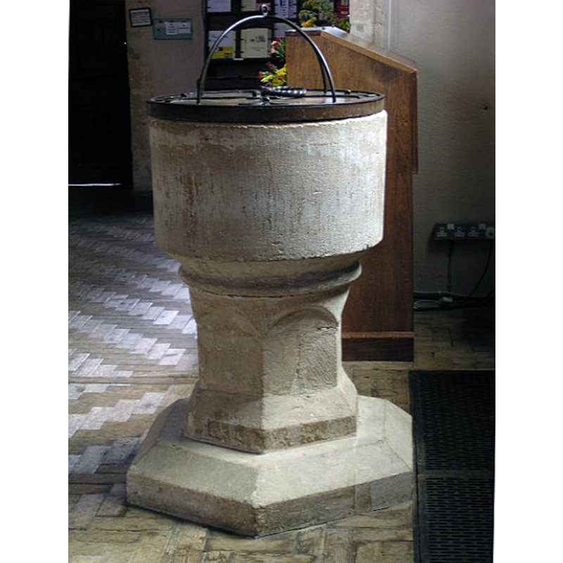
Image copyright © St. Mary's Church Cogges Parochial Church Council, 2005
No known copyright restriction / Fair Dealing
Results: 4 records
view of font and cover
Copyright Statement: Image copyright © St. Mary's Church Cogges Parochial Church Council, 2005
Image Source: digital photograph 2015 by the St. Mary's Church Cogges Parochial Church Council [http://coggesparish.com/inscrip/insideb_.htm] [accessed 27 November 2017]
Copyright Instructions: No known copyright restriction / Fair Dealing
view of church exterior - south view
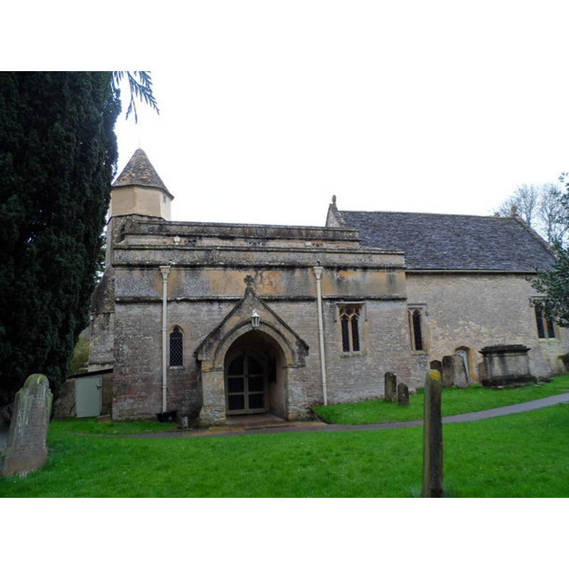
Scene Description: Source caption: ''St Mary's church Cogges. The walls of the nave are the earliest part of the church and are late Saxon or early Norman (C11). The bell tower was added in the C14 and is octagonal.''
Copyright Statement: Image copyright © Bikeboy, 2014
Image Source: digital photograph taken 7 April 2014 by Bikeboy [www.geograph.org.uk/photo/3929138] [accessed 27 November 2017]
Copyright Instructions: CC-BY-SA-2.0
view of church exterior - west tower
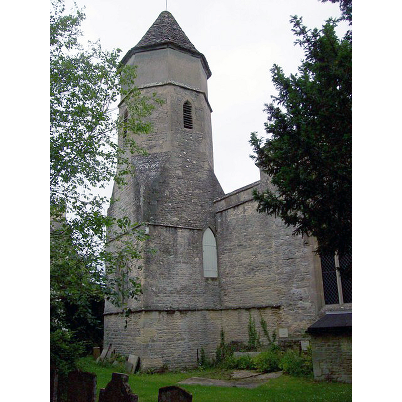
Scene Description: Source caption: "The tower of St Mary's church, Cogges, is of unusual design with a square base, octagonal trunk and conical cap. This probably reflects its original association with the Abbey of Fecamp in Normandy, which established a small "alien priory" on the site in 1103.''
Copyright Statement: Image copyright © Len Williams, 2012
Image Source: digital photograph taken 1 July 2012 by Len Williams [www.geograph.org.uk/photo/3022904] [accessed 27 November 2017]
Copyright Instructions: CC-BY-SA-2.0
view of church exterior - east view
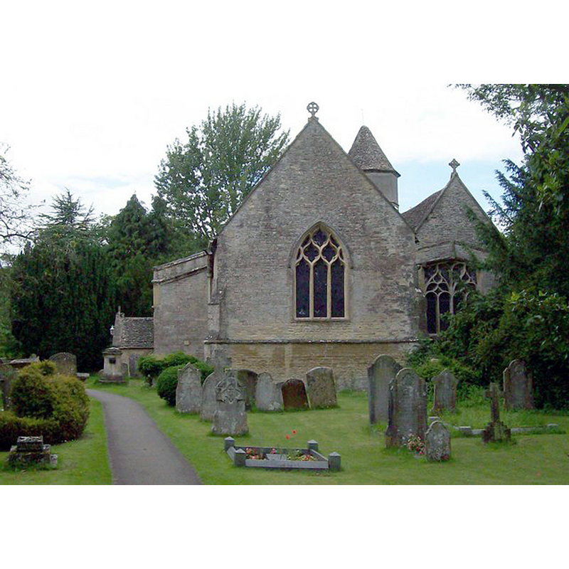
Scene Description: Source caption: "The Church of St Mary was founded in the 11th century on the site of a small "alien priory", originally tied to the Abbey of Fecamp in Normandy. The village of Cogges, (Coggs), was decimated during the "Black Death" but now forms a suburb of the town of Witney, Oxfordshire."
Copyright Statement: Image copyright © Len Williams, 2012
Image Source: digital photograph taken 1 July 2012 by Len Williams [www.geograph.org.uk/photo/3022908] [accessed 27 November 2017]
Copyright Instructions: CC-BY-SA-2.0
INFORMATION
Font ID: 12985COG
Object Type: Baptismal Font1
Font Century and Period/Style: 12th century [basin only] -- 14th century [base only] [composite font], Medieval / composite
Church / Chapel Name: Parish Church of St. Mary
Font Location in Church: Inside the church, in the W end, S side, just left of the doorway
Church Patron Saint(s): St. Mary the Virgin
Church Address: Church Lane, Witney, Oxfordshire, OX28 3LA, UK
Site Location: Oxfordshire, South East, England, United Kingdom
Directions to Site: Located off (W) the B4022, between the A4095 (N) abd the A40 (S), 1 km N of Witney
Ecclesiastic Region: Diocese of Oxford
Historical Region: Hundred of Bampton [in Domesday] -- Hundred of Wootton
Additional Comments: altered font / composite font: polygonal base a later addition/replacement
Font Notes:
Click to view
There is an entry for Cogges [variant spelling] in the Domesday survey [http://opendomesday.org/place/SP3609/cogges/] [accessed 27 November 2017], but it mentions neither priest nor church in it. Kelly's Oxford Directory of 1911 notes: "the font and the inner doorway of the porch are [...] Transtion Norman". Noted in Sherwood & Pevsner (1974): "Norman, tub-shaped, on an octagonal C14 base." The entry for this parish in the Victoria County History (Oxford, vol. 12 1990) notes: "Manasser Arsic's gift to Fécamp abbey, confirmed in 1103, included Cogges church with its land; ([...] architectural evidence suggests that the church existed by the third quarter of the 11th century. It probably began as a chapel within Eynsham minster parish, for in 1238 Eynsham abbey was receiving, 'from of old', the yearly crop of four demesne acres at Cogges in return for permitting burial there; [...] since the render, worth 6s. 8d. in 1270, came from the demesne rather than from the priory lands, the concession was presumably negotiated before 1103. The church was closely associated with the adjoining priory, which may have shared it with the villagers [...] The nave was originally aisleless; it has high, thin walls with large quoins on the west corners, and may be preConquest. The south aisle, added in the late 12th century, retains a column with a scalloped capital. In the mid 13th century the chancel was rebuilt on spacious lines [...] The plain tub-shaped font is probably 12th century, on a late medieval polygonal base". The CRSBI (2017) notes: "The church also boasts a plain font, probably 12thc [...] At W end of nave, in centre. Tub-shaped bowl. Oolitic limestone. The bowl is plain except for a broad, slightly hollow chamfer around the lower part of its surface, sloping inwards to a roll-moulding at the base. In the top edge are two modern stone patches in diametrically opposite positions, presumably replacing fixings. Stem, probably original, cylindrical at the top but cut to six flat segmental-headed faces. The stem stands on a chamfered plinth, built of several blocks of which some bear diagonal tooling. Below is a modern hexagonal base-plinth."
COORDINATES
UTM: 30U 604985 5738110
Latitude & Longitude (Decimal): 51.784, -1.478
Latitude & Longitude (DMS): 51° 47′ 2.4″ N, 1° 28′ 40.8″ W
MEDIUM AND MEASUREMENTS
Material: stone
Font Shape: tub-shaped
Basin Interior Shape: round
Basin Exterior Shape: round
Rim Thickness: 7 cm [calculated]
Diameter (inside rim): 51 cm
Diameter (includes rim): 64 cm
Basin Total Height: 43 cm
Font Height (with Plinth): 87 cm [incl. medieval plinth]
Notes on Measurements: CRSBI (2017)
LID INFORMATION
Date: modern?
Material: wood, oak?
Apparatus: no
Notes: round and flat, with metal decoration and ring handle
REFERENCES
- The Victoria History of the Counties of England: Worcestershire, London: Victoria County History, 1924, [http://www.british-history.ac.uk/report.asp?compid=5187] [accessed: 17 June 2007]
- Corpus of Romanesque Sculpture in Britain and Ireland, The Corpus of Romanesque Sculpture in Britain and Ireland, The Corpus of Romanesque Sculpture in Britain and Ireland. URL: http://www.crsbi.ac.uk.
- Kelly, Kelly's Directory of Oxfordshire, London: Kelly's Directories Ltd., 1911, p. 85 / [http://www.historicaldirectories.org/hd/d.asp] [accessed 30 June 2007]
- Pevsner, Nikolaus, Oxfordshire, Harmondsworth: Penguin Books, 1974, p. 550