Billockby / Billokeby / Bithlakebei / Bitlakebei / Bitlakelej / Byllockly
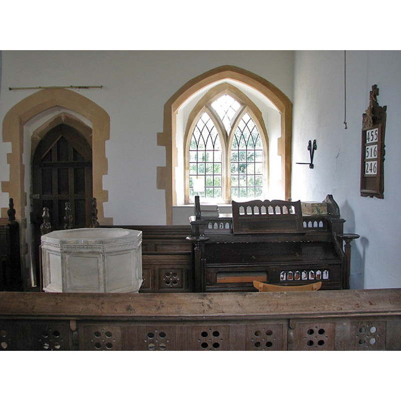
Image copyright © Evelyn Simak, 2007
CC-BY-SA-3.0
Results: 6 records
design element - motifs - panel - 8
Scene Description: [cf. Font notes]
Copyright Statement: Image copyright © Evelyn Simak, 2007
Image Source: digital photograph taken 27 June 2007 by Evelyn Simak [www.geograph.org.uk/photo/831329] [accessed 23 May 2014]
Copyright Instructions: CC-BY-SA-3.0
view of church exterior - northwest view
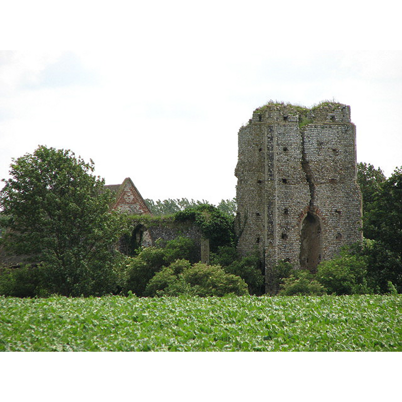
Scene Description: Photo caption: "The tower of All Saints church was struck by lightning in 1762 and has since fallen to ruin, with a large crack splitting the west tower wall almost in half. Falling masonry soon also destroyed the nave but the chancel was made safe; restored in the late 1800s it is still occasionally being used for worship."
Copyright Statement: Image copyright © Evelyn Simak, 2007
Image Source: digital photograph taken 27 June 2007 by Evelyn Simak [www.geograph.org.uk/photo/831326] [accessed 23 May 2014]
Copyright Instructions: CC-BY-SA-3.0
view of church exterior - southeast view
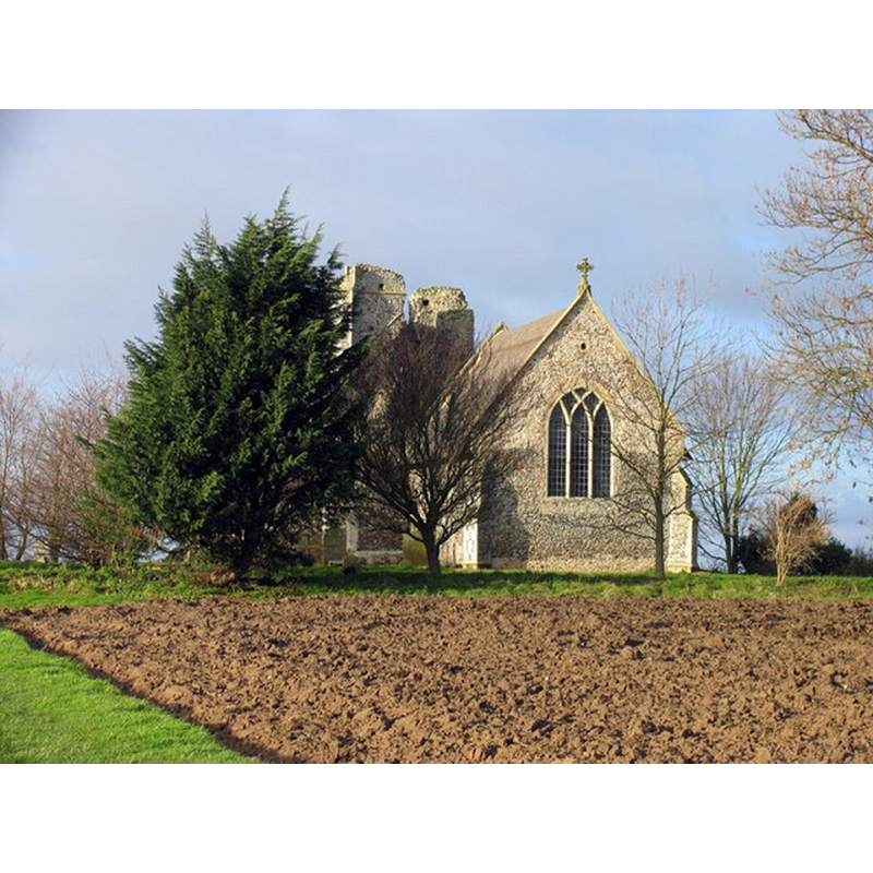
Copyright Statement: Image copyright © John Salmon, 2007
Image Source: digital photograph taken 4 January 2007 by John Salmon [www.geograph.org.uk/photo/321773] [accessed 23 May 2014]
Copyright Instructions: CC-BY-SA-3.0
view of church exterior - southeast view
![Photo caption: "Struck by lightning in 1762; on[ly] the chancel remains in use"](/static-50478a99ec6f36a15d6234548c59f63da52304e5/compressed/1140525012_compressed.png)
Scene Description: Photo caption: "Struck by lightning in 1762; on[ly] the chancel remains in use"
Copyright Statement: Image copyright © George Plunkett, 2014
Image Source: B&W photograph taken 28 November 1992 by George Plunkett [www.georgeplunkett.co.uk/Norfolk/B/Billockby All Saints church from SE [6938] 1992-11-28.jpg] [accessed 23 May 2014]
Copyright Instructions: Standing permission by Jonathan Plunkett
view of font in context
Scene Description: partial view of the basin in the context of the chancel; the latter serves now as nave in the half-ruined church
Copyright Statement: Image copyright © Evelyn Simak, 2007
Image Source: digital photograph taken 27 June 2007 by Evelyn Simak [www.geograph.org.uk/photo/831329] [accessed 23 May 2014]
Copyright Instructions: CC-BY-SA-3.0
design element - motifs - tracery
![[cf. Font notes]](/static-50478a99ec6f36a15d6234548c59f63da52304e5/others/image_not_available.jpg)
Scene Description: [cf. Font notes]
![[cf. Font notes]](/static-50478a99ec6f36a15d6234548c59f63da52304e5/bsi-testing-site/others/image_not_available.jpg)
INFORMATION
Font ID: 12926BIL
Object Type: Baptismal Font1
Font Century and Period/Style: 15th century, Perpendicular
Church / Chapel Name: Parish Church of All Saints
Font Location in Church: Inside the church, in the remaining part, the former chancel
Church Patron Saint(s): All Saints
Church Address: Church Lane, Fleggburgh, Norfolk NR29 3BE
Site Location: Norfolk, East Anglia, England, United Kingdom
Directions to Site: Located between Acle and Stalham
Ecclesiastic Region: Diocese of Norwich
Historical Region: Hundred of West Flegg
Additional Comments: moved font? (the present one, from its original position to the surviving chancel) -- disappeared font? (the one from the original Domesday-time church here)
Font Notes:
Click to view
There are four entries for Billockby [variant spelling] in the Domesday survey [http://domesdaymap.co.uk/place/TG4213/billockby/] [accessed 23 May 2014], one of which reports a church and churchlands in it. Blomefield (1805-1810) notes that "two parts of the church endowed with 7 acres" were in the part held in 1086 by Bernard [aka Bernar] for Bishop William of Thetford, who was the tennant-in-chief. Blomefield (ibid.) adds: "The Church is dedicated to All-Saints, and is a rectory". The present font is noted in Pevsner & Wilson (1997): "Font. Octagonal, Perp[endicular], with very simple panels, those on the stem with tracery." The building was hit by a lightning strike in 1762; only the old chancel -which now houses the font- was restored in the 19th century. [NB: we have no information on the font of the Domesday-time church here].
Credit and Acknowledgements: We are grateful to Jonathan Plunkett for the photograph of this church, taken by his father, George Plunkett, in 1992
COORDINATES
UTM: 31U 404753 5836026
Latitude & Longitude (Decimal): 52.665804, 1.591557
Latitude & Longitude (DMS): 52° 39′ 56.89″ N, 1° 35′ 29.6″ E
MEDIUM AND MEASUREMENTS
Material: stone
Font Shape: octagonal, mounted
Basin Interior Shape: round
Basin Exterior Shape: octagonal
REFERENCES
- Blomefield, Francis, An essay towards a topographical history of Norfolk, 1805-1810, vol. 11: 149-152 / [www.british-history.ac.uk/report.aspx?compid=78771] [accessed 23 May 2014]
- Pevsner, Nikolaus, Norfolk 1: Norwich and North-East [2nd ed.], Harmondsworth: Penguin Books, 1997, p. 389