Barton Turf / B'tuna / Barton by Bromholm / Bartuna / Berton
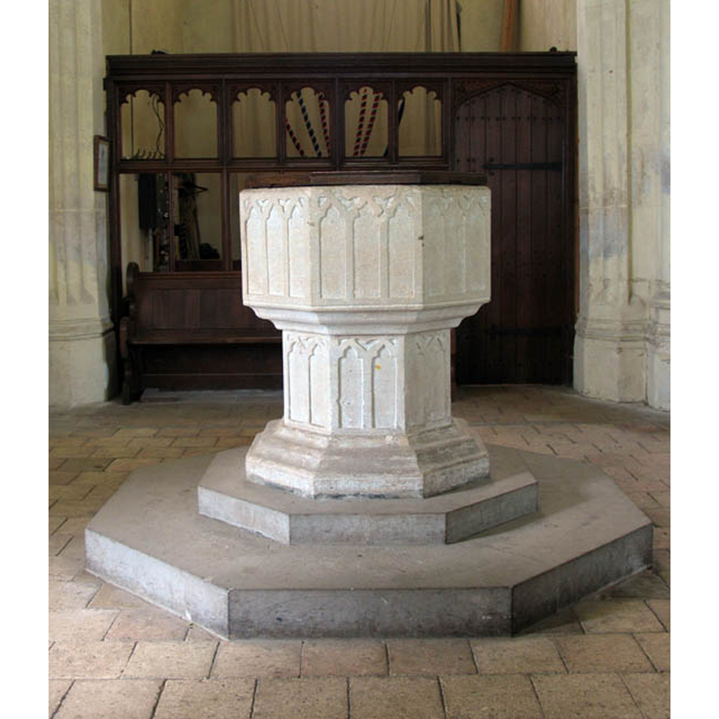
Image copyright © John Salmon, 2007
Reproduced under the provisions of the Creative Commons Attribution-Share Alike 2.0 Generic Licence
Results: 13 records
view of font and cover
Copyright Statement: Image copyright © John Salmon, 2007
Image Source: digital photograph taken 31 May 2007 by John Salmon [www.geograph.org.uk/photo/481391] [accessed 23 April 2014]
Copyright Instructions: Reproduced under the provisions of the Creative Commons Attribution-Share Alike 2.0 Generic Licence
view of font and cover in context
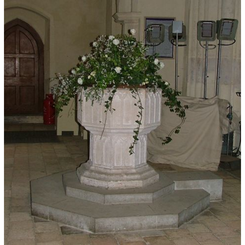
Copyright Statement: Image copyright © Simon Knott, 2004
Image Source: digital photograph by Simon Knott 2004 [www.norfolkchurches.co.uk/bartonturf/bartonturf.htm] [accessed 5 April 2007]
Copyright Instructions: Standing permission
design element - architectural - arch or window - trefoiled - 24
Scene Description: three on each side of the basin
Copyright Statement: Image copyright © Simon Knott, 2004
Image Source: digital photograph by Simon Knott 2004 [www.norfolkchurches.co.uk/bartonturf/bartonturf.htm] [accessed 5 April 2007]
Copyright Instructions: Standing permission
view of church exterior - west portal
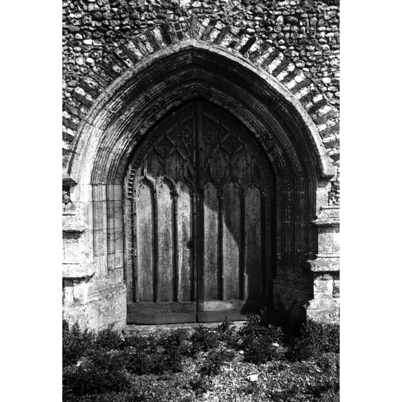
Scene Description: Photo caption: "15thc door"
Copyright Statement: Image copyright © George Plunkett, 2014
Image Source: B&W photograph taken 9 July 1940 by George Plunkett [www.georgeplunkett.co.uk/Norfolk/B/Barton Turf St Michael All Angels west door [3457] 1940-07-09.jpg] [accessed 23 April 2014]
Copyright Instructions: Standing permission by Jonathan Plunkett
view of church exterior - southeast view
![Photo caption: "The stairs of the 15c tower go up level with the parapet"
INT SCREEN digital photograph taken 31 May 2007 by John Salmon [www.geograph.org.uk/photo/481397] [accessed 23 April 2014]
INT SCREEN2 digital photograph taken 31 May 2007 by John Salmon [www.geograph.org.uk/photo/481400] [accessed 23 April 2014]
FONT digital photograph taken 31 May 2007 by John Salmon [www.geograph.org.uk/photo/481391] [accessed 23 April 2014]](/static-50478a99ec6f36a15d6234548c59f63da52304e5/compressed/1140426021_compressed.png)
Scene Description: Photo caption: "The stairs of the 15c tower go up level with the parapet"
INT SCREEN digital photograph taken 31 May 2007 by John Salmon [www.geograph.org.uk/photo/481397] [accessed 23 April 2014]
INT SCREEN2 digital photograph taken 31 May 2007 by John Salmon [www.geograph.org.uk/photo/481400] [accessed 23 April 2014]
FONT digital photograph taken 31 May 2007 by John Salmon [www.geograph.org.uk/photo/481391] [accessed 23 April 2014]
Copyright Statement: Image copyright © George Plunkett, 2014
Image Source: B&W photograph taken 9 July 1940 by George Plunkett [www.georgeplunkett.co.uk/Norfolk/B/Barton Turf St Michael All Angels church SE [3453] 1940-07-09.jpg] [accessed 23 April 2014]
Copyright Instructions: Standing permission by Jonathan Plunkett
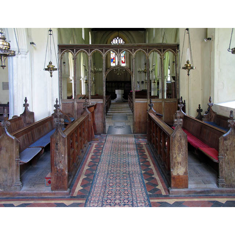
view of church interior - chancel - rood-screen, choir-screen; iconostasis
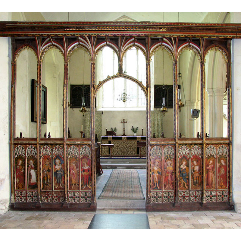
Scene Description: showing the west side of the screen
Copyright Statement: Image copyright © Evelyn Simak, 2010
Image Source: digital photograph taken 2 August 2010 by Evelyn Simak [www.geograph.org.uk/photo/1995084] [accessed 26 April 2014]
Copyright Instructions: CC-BY-SA-3.0
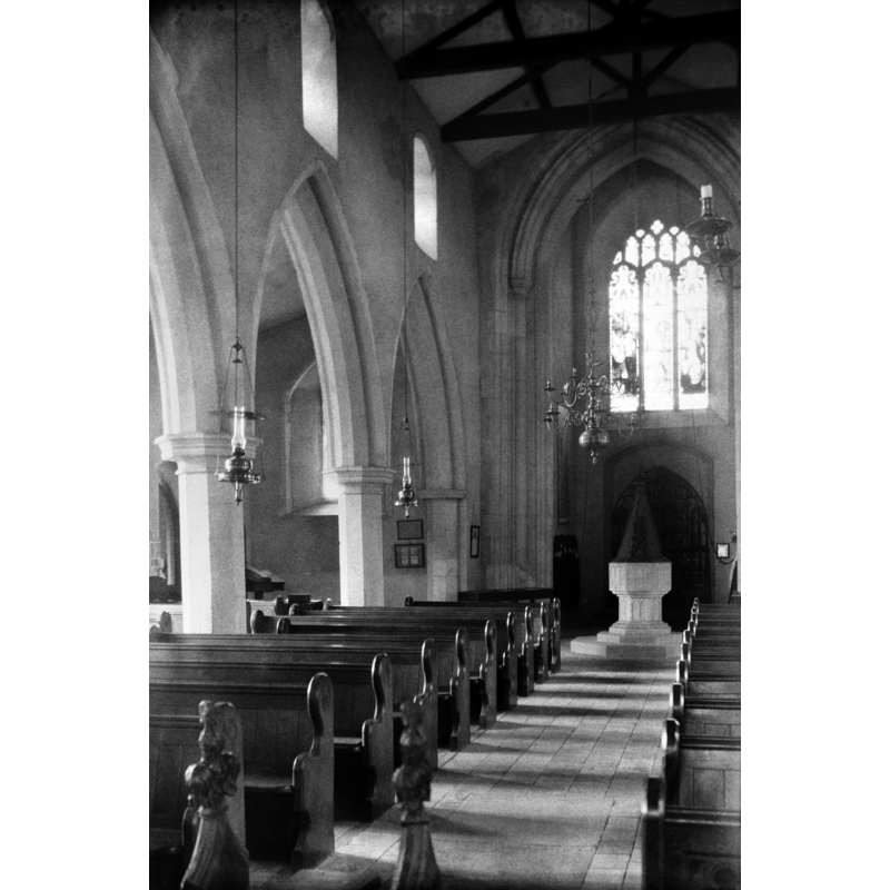
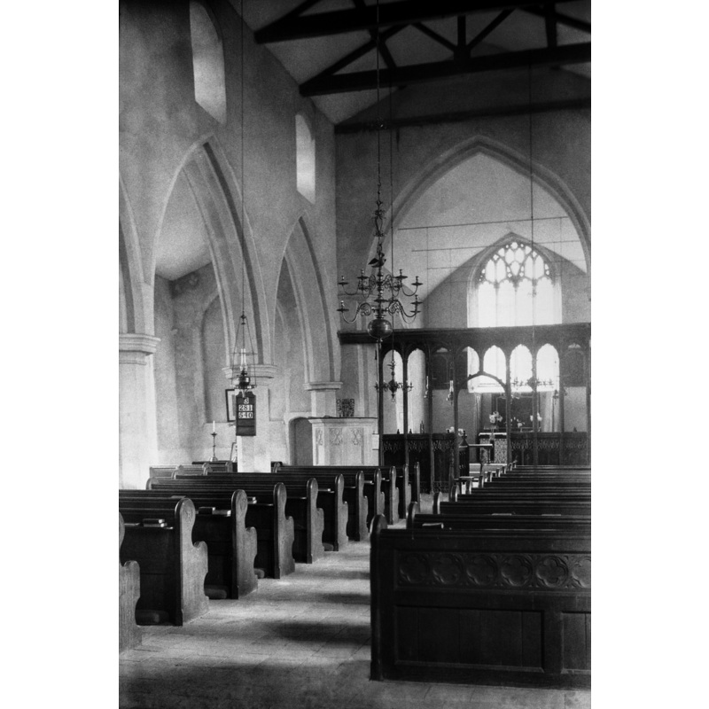
view of church interior - looking west
Scene Description: seen from inside the chancel -- showing the plain east side of the chancel screen
Copyright Statement: Image copyright © John Salmon, 2007
Image Source: digital photograph taken 31 May 2007 by John Salmon [www.geograph.org.uk/photo/481396] [accessed 23 April 2014]
Copyright Instructions: CC-BY-SA-3.0
view of church interior - chancel - rood-screen, choir-screen; iconostasis - dais - detail
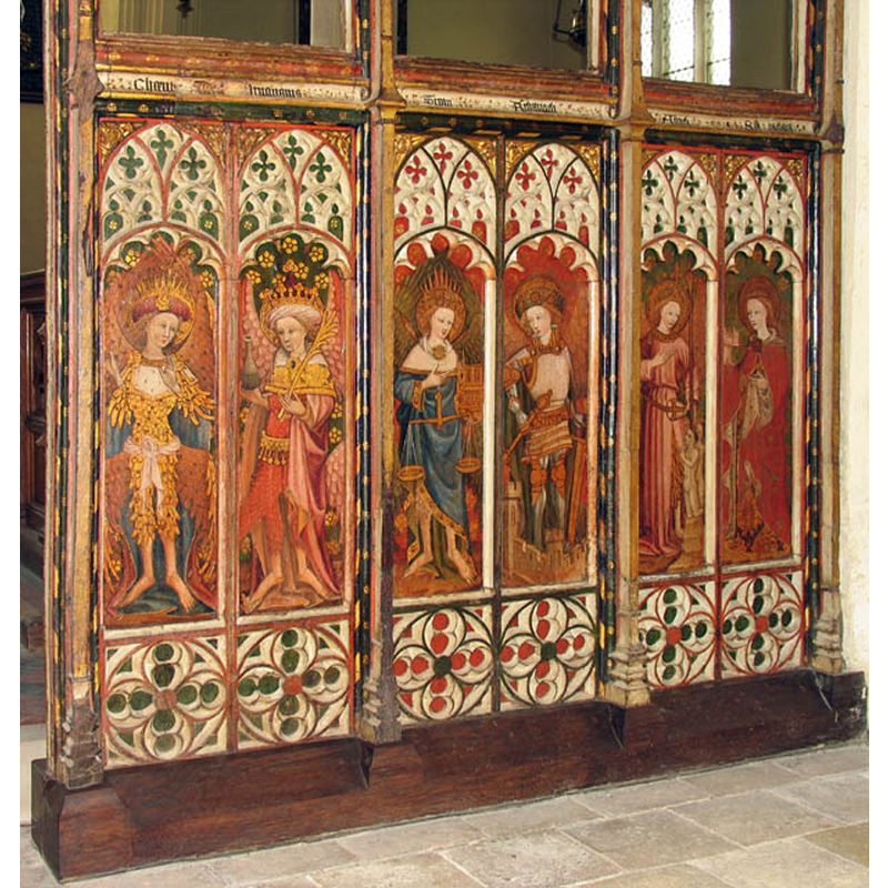
Scene Description: the west face, south half
Copyright Statement: Image copyright © John Salmon, 2007
Image Source: digital photograph taken 31 May 2007 by John Salmon [www.geograph.org.uk/photo/481397] [accessed 23 April 2014]
Copyright Instructions: CC-BY-SA-3.0
view of church interior - chancel - rood-screen, choir-screen; iconostasis - dais - detail
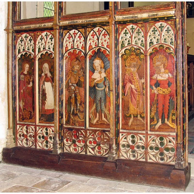
Scene Description: the west face, north half
Copyright Statement: Image copyright © John Salmon, 2007
Image Source: digital photograph taken 31 May 2007 by John Salmon [www.geograph.org.uk/photo/481400] [accessed 23 April 2014]
Copyright Instructions: CC-BY-SA-3.0
view of church interior - nave - looking west
Scene Description: Photo caption: "15thc font" -- the font and its old cover are visible at the west end -- the old cover is no longer present in the church, and has been replaced by a modern one, octagonal and flat
Copyright Statement: Image copyright © George Plunkett, 2014
Image Source: B&W photograph taken 9 July 1940 by George Plunkett [www.georgeplunkett.co.uk/Norfolk/B/Barton Turf St Michael All Angels int west [3456] 1940-07-09.jpg] [accessed 23 April 2014]
Copyright Instructions: Standing permission by Jonathan Plunkett
view of church interior - nave - looking east
Copyright Statement: Image copyright © George Plunkett, 2014
Image Source: B&W photograph taken 9 July 1940 by George Plunkett [www.georgeplunkett.co.uk/Norfolk/B/Barton Turf St Michael All Angels int east [3455] 1940-07-09.jpg] [accessed 23 April 2014]
Copyright Instructions: Standing permission by Jonathan Plunkett
design element - architectural - arch or window - trefoiled - 16
Scene Description: two on each side of the stem
Copyright Statement: Image copyright © Simon Knott, 2004
Image Source: digital photograph by Simon Knott 2004 [www.norfolkchurches.co.uk/bartonturf/bartonturf.htm] [accessed 5 April 2007]
Copyright Instructions: Standing permission
design element - motifs - moulding - graded
Scene Description: on the lower base
Copyright Statement: Image copyright © Simon Knott, 2004
Image Source: digital photograph by Simon Knott 2004 [www.norfolkchurches.co.uk/bartonturf/bartonturf.htm] [accessed 5 April 2007]
Copyright Instructions: Standing permission
INFORMATION
Font ID: 12920BAR
Object Type: Baptismal Font1
Font Century and Period/Style: 15th century, Perpendicular
Church / Chapel Name: Parish Church of St. Michael
Font Location in Church: Inside the church, in the W end of the nave
Church Patron Saint(s): St. Michael
Church Address: Church Road, Barton Turf, Norfolk, NR12 8YU
Site Location: Norfolk, East Anglia, England, United Kingdom
Directions to Site: Located off (S) the A1151, 20 km NE of Norwich
Ecclesiastic Region: Diocese of Norwich
Historical Region: Hundred of Tunstede
Additional Comments: altered font? (re-carved? / re-tooled? the present font) -- disappeared font? (two, of the churches surveyed in the Domesday survey)
Font Notes:
Click to view
There are three entries for Barton [Turf] in the Domesaday survey [http://domesdaymap.co.uk/place/TG3421/barton-turf/] [accessed 23 April 2014], of which two report church and church lands in them. Blomefield (1805-1810) writes: "B[arton], Called in old writings, Barton by Bromholm, and Barton Turf. The principal part of it, or manor, was in the reign of the Confessor, in the abbey of St. Bennet's at Holm", and notes two churches in it "in King Edward's time" [i.e., 1272-1307]; "The Church is dedicated to St. Michael, and was a rectory in the presentation of the abbot and convent of St. Bennet of Holm, valued at 13 marks; in the 18th of Richard II [i.e., 1395] it was appropriated to it, and a vicarage endowed". Pevsner & Wilson (1997) note: "Font. Is it old at all? Stem and bowl with the same motif of flatly carved trefoil-headed panels." Illustrated in Knott (2004). The font consists of an octagonal basin with vertical sides decorated with a blind arcade of trefoil-headed arches; graded moulding on the underbowl; the octagonal stem has an arcade similar to the one around the basin; the lower base is graded; two-step plinth with kneeling stone. Wooden cover. [NB: Pevsner et al.'s doubts about the date [cf. supra] may relate probably to the neat and fresh appearance of the carving; re-tooled?]. Noted in Leach (1975) as "fragments found in the churchyard and during the demolition of a cottage" from a font made of Purbeck marble [source given: The Rev. W.C. Hall].
Credit and Acknowledgements: We are grateful to Simon Knott, of Norfolk Churches, for his photograph of this font; we are also grateful to Jonathan Plunkett for the photographs of this church taken by his father, George Plunkett, in 1940
COORDINATES
UTM: 31U 396697 5844781
Latitude & Longitude (Decimal): 52.743008, 1.469715
Latitude & Longitude (DMS): 52° 44′ 34.83″ N, 1° 28′ 10.97″ E
MEDIUM AND MEASUREMENTS
Material: stone
Font Shape: octagonal, mounted
Basin Interior Shape: round
Basin Exterior Shape: octagonal
LID INFORMATION
Material: wood, oak?
Apparatus: no
Notes: [cf. FontNotes and ImageArea]
REFERENCES
- Blomefield, Francis, An essay towards a topographical history of Norfolk, 1805-1810, vol. 11: 3-6 / [www.british-history.ac.uk/report.aspx?compid=78728] [accessed 23 April 2014]
- Knott, Simon, The Norfolk Churches Site, Simon Knott, 2004. [standing permission to reproduce images received from Simon (February 2005]. URL: www.norfolkchurches.co.uk.
- Leach, Rosemary, A Investigation into the use of Purbeck Marble in Medieval England, Hartlepool: E.W. Harrisons & Sons, 1975, p. 69
- Pevsner, Nikolaus, Norfolk 1: Norwich and North-East [2nd ed.], Harmondsworth: Penguin Books, 1997, p. 380