Northolt / Northala
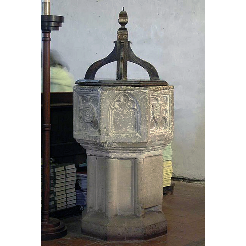
Image copyright © John Salmon, 2010
CC-BY-SA-2.0
Results: 6 records
view of font and cover
Copyright Statement: Image copyright © John Salmon, 2010
Image Source: digital photograph taken 1 December 2001 by John Salmon [www.geograph.org.uk/photo/1592417] [accessed 12 June 2019]
Copyright Instructions: CC-BY-SA-2.0
design element - motifs - floral - rose - in a hexafoil - pointed hexafoil
Scene Description: seen here on the left panel
Copyright Statement: Image copyright © John Salmon, 2010
Image Source: digital photograph taken 1 December 2001 by John Salmon [www.geograph.org.uk/photo/1592417] [accessed 12 June 2019]
Copyright Instructions: CC-BY-SA-2.0
design element - architectural - arch or window - cinquefoiled
Scene Description: seen here in the centre
Copyright Statement: Image copyright © John Salmon, 2010
Image Source: digital photograph taken 1 December 2001 by John Salmon [www.geograph.org.uk/photo/1592417] [accessed 12 June 2019]
Copyright Instructions: CC-BY-SA-2.0
symbol - shield - charged - unidentified
Scene Description: perhaps the coat of arms or emblem of Nicholas Bembre, a lord of the Manor and Lord Mayor of London, donor of the font
Copyright Statement: Image copyright © John Salmon, 2010
Image Source: digital photograph taken 1 December 2001 by John Salmon [www.geograph.org.uk/photo/1592417] [accessed 12 June 2019]
Copyright Instructions: CC-BY-SA-2.0
view of church exterior - northwest view
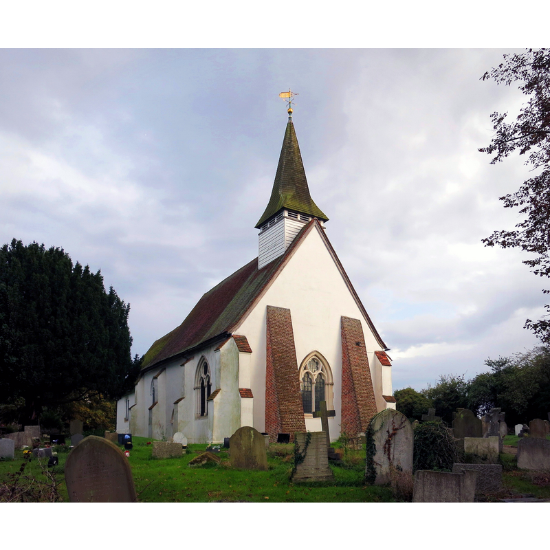
Scene Description: Source caption: "St. Mary's Church, Northolt. Better known as an airfield and a station on the London Underground, it's easy to forget that Northolt, like many places round here, is an ancient settlement. It was called Northala in the Domesday Book. The parish church is from the 13th century."
Copyright Statement: Image copyright © Des Blemkinsopp, 2014
Image Source: digital photograph taken 9 October 2014 by Des Blenkinsopp [www.geograph.org.uk/photo/4203985] [accessed 12 June 2019]
Copyright Instructions: CC-BY-SA-2.0
view of church exterior - southeast view
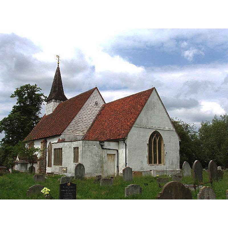
Copyright Statement: Image copyright © David Hawgood, 2005
Image Source: digital photograph taken 11 June 2005 by David Hawgood [www.geograph.org.uk/photo/17539] [accessed 12 June 2019]
Copyright Instructions: CC-BY-SA-2.0
INFORMATION
Font ID: 12880NOR
Object Type: Baptismal Font1
Font Century and Period/Style: 14th century (late?) [basin only] [composite font], late Medieval / composite
Workshop/Group/Artisan: heraldic font
Church / Chapel Name: Parish Church of St. Mary
Font Location in Church: Inside the church
Church Patron Saint(s): St. Mary the Virgin
Church Address: Ealing Rd, Northolt UB5 6AA, UKnited Kingdom
Phone: +44 20 8841 5691
Site Location: Greater London, South East, England, United Kingdom
Directions to Site: Located off (S) of Church Rd, N of the A40, 400-500 yards S of the Norholt Underground station, 18 km WNW of Charing Cross
Ecclesiastic Region: Diocese of London
Historical Region: Hundred of Elthorne -- formerly Middlesex
Additional Comments: altered font (the present font has an original basin on a replacement base) -- disappeared font? (the one from the Domesday-time church here)
Font Notes:
Click to view
There is an entry for Northolt [variant spelling] in the Domesday survey [https://opendomesday.org/place/TQ1284/northolt/] [accessed 12 June 2019]; it reports a priest and "0.5 church lands", but not a church itself in it, though there must have been one there. Pevsner (1951) writes: "Font. Octagonal, with simply decorated panels of late C14 character. The cover is 1624." The entry for this parish in the Victoria County History (Middlesex, vol. 4, 1971) notes: "There was a priest at Northolt in 1086. [...] A church is mentioned c. 1140, although the oldest parts of the present building have been assigned to the 13th century. [...] [it] dates in part from the early 14th century with early-16th-century additions. [...] The octagonal stone font dates from the 14th century. The bowl is decorated with simple relief carving, and the wooden cover is dated 1624" [the VCH footnotes the entry: "Hist. Mon. Com. Mdx. pl. 12"]. The Ealing web site [www.ealing.gov.uk] [accessed 27 March 2007] informs: "fourteenth century font, given by Nicholas Bembre, a lord of the Manor and Lord Mayor of London".
COORDINATES
UTM: 30U 682443 5713592
Latitude & Longitude (Decimal): 51.543889, -0.368889
Latitude & Longitude (DMS): 51° 32′ 38″ N, 0° 22′ 8″ W
MEDIUM AND MEASUREMENTS
Material: stone
Font Shape: octagonal, mounted
Basin Interior Shape: round
Basin Exterior Shape: octagonal
LID INFORMATION
Date: 1624
Material: wood, oak?
Notes: [cf. FontNotes]
REFERENCES
- Victoria County History [online], University of London, 1993-. URL: https://www.british-history.ac.uk.
- Pevsner, Nikolaus, Middlesex, Harmondsworth: Penguin Books, 1951, p. 127