Stoulton / Stoltun / Stowton / Stulton
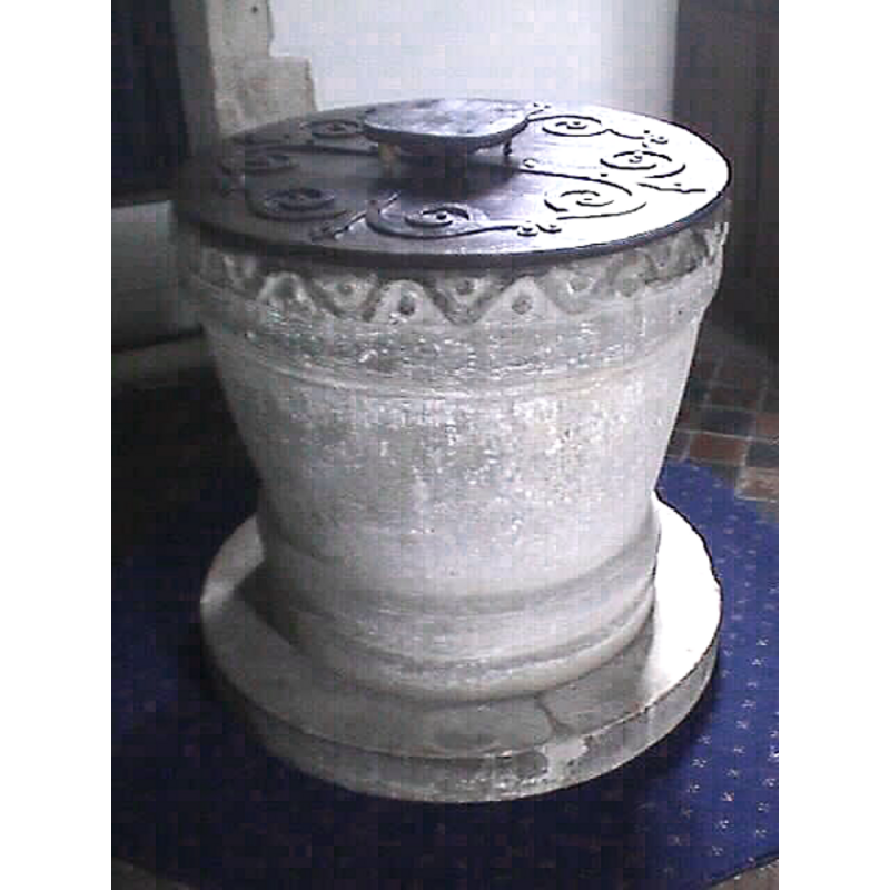
Image copyright © John Wilkes, 2008
Standing permission
Results: 6 records
view of font and cover
Copyright Statement: Image copyright © John Wilkes, 2008
Image Source: digital photograph by John Wilkes taken September 2008
Copyright Instructions: Standing permission
design element - motifs - wave - beaded-tape
Copyright Statement: Image copyright © John Wilkes, 2008
Image Source: digital photograph by John Wilkes taken September 2008
Copyright Instructions: Standing permission
design element - motifs - roll moulding
Copyright Statement: Image copyright © John Wilkes, 2008
Image Source: digital photograph by John Wilkes taken September 2008
Copyright Instructions: Standing permission
design element - motifs - roll moulding
Copyright Statement: Image copyright © John Wilkes, 2008
Image Source: digital photograph by John Wilkes taken September 2008
Copyright Instructions: Standing permission
view of church exterior - south view
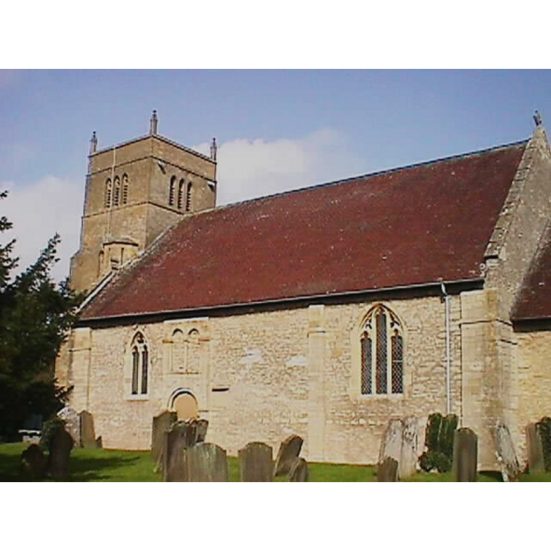
Copyright Statement: Image copyright © John Wilkes, 2008
Image Source: digital photograph by John Wilkes taken September 2008
Copyright Instructions: Standing permission
view of font

Copyright Statement: Image copyright © The Corpus of Romanesque Sculpture in Britain and Ireland, 2014
Image Source: B&W photograph [by?] G.L. Pearson in the CRSBI [www.crsbi.ac.uk/site/885/] [accessed 9 March 2007]
Copyright Instructions: PERMISSION NOT AVAILABLE -- IMAGE NOT FOR PUBLIC USE
INFORMATION
Font ID: 12789STO
Object Type: Baptismal Font1
Font Date: ca. 1120?
Font Century and Period/Style: 12th century (early?), Norman
Church / Chapel Name: Parish Church of St. Edmund, King and Martyr
Font Location in Church: Inside the church
Church Patron Saint(s): St. Edmund the Martyr [aka Edmund of East Anglia]
Church Address: Church Lane, Stoulton, Worcestershire WR7 4RS
Site Location: Worcestershire, West Midlands, England, United Kingdom
Directions to Site: Located 6 NW of Pershore
Ecclesiastic Region: Diocese of Worcester
Historical Region: Hundred of Oswaldslow [in Domesday] -- Hundred of Halfshire
Additional Comments: altered font? [cf. CRSBI suggestion in FontNotes] -- Message from John Wilkes: "Stoulton has a good Norman font but I was in a hurry because a wedding was imminent so sadly cut the picture off before saving it -- Exterior of St Edmund's attached "
Font Notes:
Click to view
There is an entry for Stoulton [variant spelling] in the Domesday survey [http://domesdaymap.co.uk/place/SO9049/stoulton/] [accessed 1 October 2014], but it mentions neither cleric nor church in it. Lewis' Dictionary of 1848 reports "a curious font" in this church. Noake (1848) notes: "The font is an interesting specimen of the early Norman: it is circular, large enough for total immersion, and its pedestal is in the shape of another basin, reversed; the top edge is ornamented with a roll and fillet, surmounted by a zigzag and pellets." Noted as a Norman font in Miller (1890). The Victoria County History (Worcester, vol. 3, 1913) notes: "The history of the church is simple, as it has never been enlarged since it was built about the year 1120. [...] the font [...] dates from the erection of the church [i.e., ca. 1120]; it is cut from one block 2 3/4 ft. wide by 2 1/3 ft. high, and is round on plan, with sides tapering to the base. It is moulded at the base and near the top." English Heritage (1965) reports: "The C12 tub font has a band of wavy lines around the rim." In Pevsner (1968): "Font. Norman, round, with tapering sides. Wavy top band." The Open Churches Trust web site [www.openchurchestrust.org.uk/Churches/Stoulton.htm] [accessed 9 March 2007] notes: "The font is the original placed in the church at the time of building [cf. supra], cut from one piece of stone tapering towards the base with wave and pellet mouldings." In Brooks & Pevsner (2007) as Norman. The CRSBI orpus of Romanesque Sculpture in Britain and Ireland (2008), which describes and illustrates this font, suggests that the upper rim of the basin "may have been cut down".
Credit and Acknowledgements: We are grateful to John Wilkes, of www.allthecotswolds.com, for his photographs of church and font
COORDINATES
UTM: 30U 558929 5777672
Latitude & Longitude (Decimal): 52.146406, -2.138786
Latitude & Longitude (DMS): 52° 8′ 47.06″ N, 2° 8′ 19.63″ W
MEDIUM AND MEASUREMENTS
Material: stone
Font Shape: bucket-shaped, unmounted
Basin Interior Shape: round
Basin Exterior Shape: round
Rim Thickness: 9.5 cm [calculated]
Diameter (inside rim): 65 cm**
Diameter (includes rim): 80 cm* / 84 cm**
Basin Depth: 33 cm**
Basin Total Height: 60 cm*
Font Height (less Plinth): 71.5 cm**
Notes on Measurements: * [given in feet in the VCH -- cf. FontNotes] -- ** [CRSBI (2008)]
REFERENCES
- Victoria County History [online], University of London, 1993-. URL: https://www.british-history.ac.uk.
- Brooks, Alan, Worcestershire, New Haven; London: Yale University Press, 2007, p. 610
- Corpus of Romanesque Sculpture in Britain and Ireland, The Corpus of Romanesque Sculpture in Britain and Ireland, The Corpus of Romanesque Sculpture in Britain and Ireland. URL: http://www.crsbi.ac.uk.
- Lewis, Samuel, A Topographical Dictionary of England, Comprising the Several Counties, Cities, Boroughs, Corporate and Market Towns, Parishes, Chapelries, and Townships, and the Islands of Guernsy, Jersey, and Man, with Historical and Statistical Descriptions [...], London: S. Lewis, 1831, [www.british-history.ac.uk/report.asp?compid=51310] [accessed 2 March 2007]
- Miller, George [Revd.], The Parishes of the Diocese of Worcester, Birmingham: Hall & English, 1890, vol. 2: 131
- Noake, John, The rambler in Worcestershire, or, Stray notes on churches and congregations, Worcester: Published and sold by all booksellers, 1848, p. 136
- Pevsner, Nikolaus, Worcestershire, Harmondsworth: Penguin, 1968, p. 267-268