Stonehouse / Stanhus
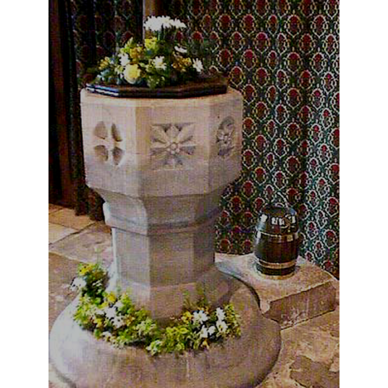
Image copyright © John Wilkes, 2008
Standing permission
Results: 7 records
view of font and cover
Scene Description: the modern font
Copyright Statement: Image copyright © John Wilkes, 2008
Image Source: digital photograph by John Wilkes, in The Gloucestershire Photo Library [http://www.allthecotswolds.com/] [accessed 5 January 2008]
Copyright Instructions: Standing permission
view of font and cover
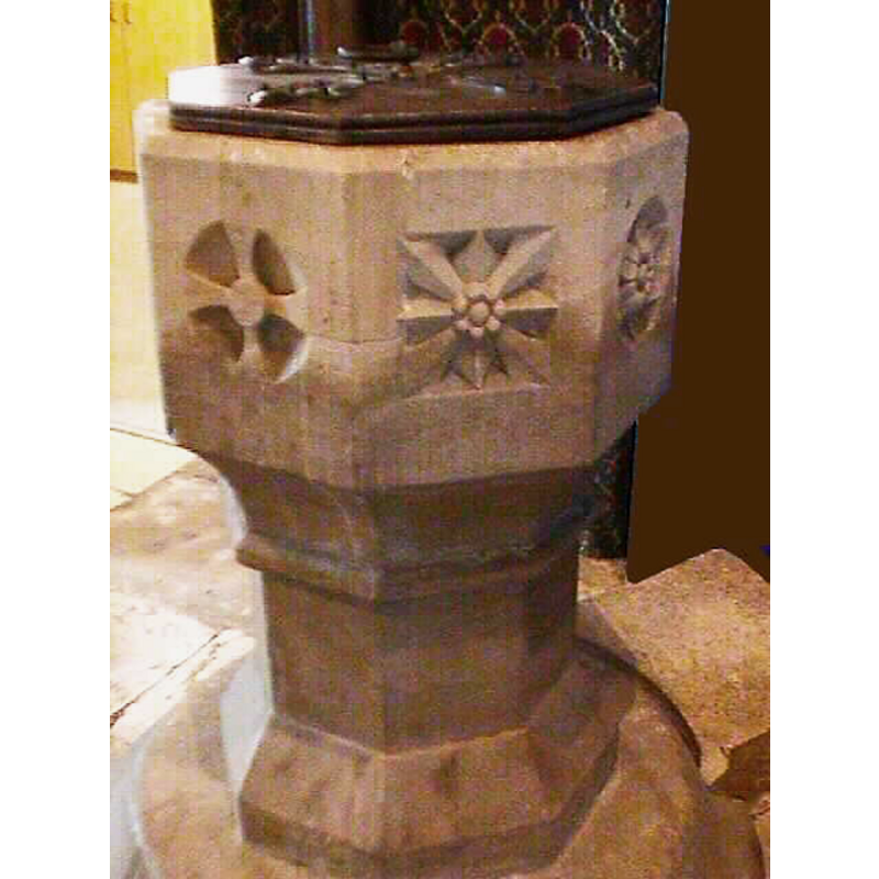
Scene Description: the modern font
Copyright Statement: Image copyright © John Wilkes, 2008
Image Source: digital photograph by John Wilkes, in The Gloucestershire Photo Library [http://www.allthecotswolds.com/] [accessed 5 January 2008]
Copyright Instructions: Standing permission
view of church exterior - east view
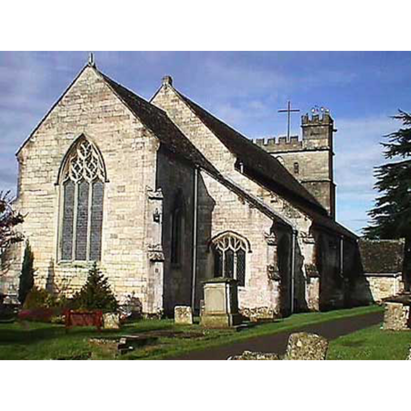
Copyright Statement: Image copyright © John Wilkes, 2008
Image Source: digital photograph by John Wilkes, in The Gloucestershire Photo Library [http://www.allthecotswolds.com/] [accessed 5 January 2008]
Copyright Instructions: Standing permission
view of church exterior - west end

Copyright Statement: Image copyright © John Wilkes, 2008
Image Source: digital photograph by John Wilkes, in The Gloucestershire Photo Library [http://www.allthecotswolds.com/] [accessed 5 January 2008]
Copyright Instructions: Standing permission
view of church interior - nave - looking east
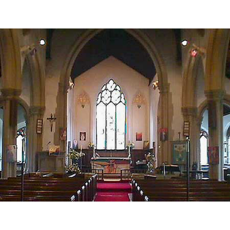
Copyright Statement: Image copyright © John Wilkes, 2008
Image Source: digital photograph by John Wilkes, in The Gloucestershire Photo Library [http://www.allthecotswolds.com/] [accessed 5 January 2008]
Copyright Instructions: Standing permission
symbol - star
![on the disappeared Norman font [cf. FontNotes]](/static-50478a99ec6f36a15d6234548c59f63da52304e5/others/image_not_available.jpg)
Scene Description: on the disappeared Norman font [cf. FontNotes]
![on the disappeared Norman font [cf. FontNotes]](/static-50478a99ec6f36a15d6234548c59f63da52304e5/bsi-testing-site/others/image_not_available.jpg)
design element - architectural - boss
Scene Description: on the disappeared Norman font [cf. FontNotes]
INFORMATION
Font ID: 12744STO
Object Type: Baptismal Font1
Font Century and Period/Style: 12th century, Late Norman? / Transitional?
Church / Chapel Name: Parish Church of St. Cyr
Font Location in Church: [cf. FontNotes]
Church Patron Saint(s): St. Cyricus [aka Cyriacus, Quiriac, Quiricus, Cyr]
Church Address: Church Ln, Stonehouse, Gloucester GL10 3QP, UK
Site Location: Gloucestershire, South West, England, United Kingdom
Directions to Site: Located off (N) the A419, 5 km WNW of Stroud
Ecclesiastic Region: Diocese of Gloucester
Historical Region: Hundred of Whitstone -- Hundred of Bachelaue [in Domesday]
Additional Comments: disappeared font (the Norman font of this church noted in Smith [cf. VCH footnote in FontNotes])
Font Notes:
Click to view
There is an entry for this Stonehouse [variant spelling] in the Domesday survey [https://opendomesday.org/place/SO8005/stonehouse/] [accessed 15 February 2019] but it mentions neither cleric nor church in it. The entry for this parish in the Victoria County History (Gloucester, vol. 10, 1972) notes: "The church at Stonehouse was probably founded by one of the lords of the manor in the 12th century [...] The oldest parts of the fabric of the earlier church were a Norman north doorway with billet ornament, and a window of the same period in the north wall of the chancel. The church also had a Norman font with star and boss ornament. [...] The north doorway and some of the decoration on the font, however, were copied from their Norman originals." [the latter references in the VCH is footnoted: "Smith, 'Book of Stonehouse', 43." -- this probably refers to C. L. Smith, 'The Book of Stonehouse' (1912)]. Verey & Brooks (1999-2002) note a font from ca. 1853. Baptismal font consisting of an octagonal basin with vertical sides, the panels carved with basin decorative motifs: cross, floral, etc.); upper rim chamfered; chamfered underbowl, slightly concave, with round moulding at the top of the octagonal stem; plain splaying lower base, also octagonal. Flat octagonal wooden cover with metal decoration and ring handle; modern. The font probably dates to the mid-19th century renovation of this church [NB: we have no information on the present whereabouts of the Norman font of this church].
Credit and Acknowledgements: We are grateful to John Wilkes, of The Gloucestershire Photo Library, for his photographs of church and font.
COORDINATES
UTM: 30U 549439 5733237
Latitude & Longitude (Decimal): 51.74785, -2.28386
Latitude & Longitude (DMS): 51° 44′ 52.26″ N, 2° 17′ 1.9″ W
MEDIUM AND MEASUREMENTS
Material: stone
REFERENCES
- Victoria County History [online], University of London, 1993-. URL: https://www.british-history.ac.uk.
- Verey, David, Gloucestershire, London: Penguin Books, 1999-2002, vol. 2: 699