Mollington / Molitone / Molletone / Mollitone
Image copyright © Basher Eyre, 2016
CC-BY-SA-2.0
Results: 5 records
design element - motifs - diaper
Scene Description: all around the upper rim
Copyright Statement: Image copyright © Basher Eyre, 2016
Image Source: digital photograph taken 31 August 2016 by Basher Eyre [www.geograph.org.uk/photo/5098726] [accessed 13 November 2017]
Copyright Instructions: CC-BY-SA-2.0
design element - architectural - arch-head - round - intersecting
Scene Description: all around the upper half of the basin
Copyright Statement: Image copyright © Basher Eyre, 2016
Image Source: digital photograph taken 31 August 2016 by Basher Eyre [www.geograph.org.uk/photo/5098726] [accessed 13 November 2017]
Copyright Instructions: CC-BY-SA-2.0
view of church exterior - northeast view
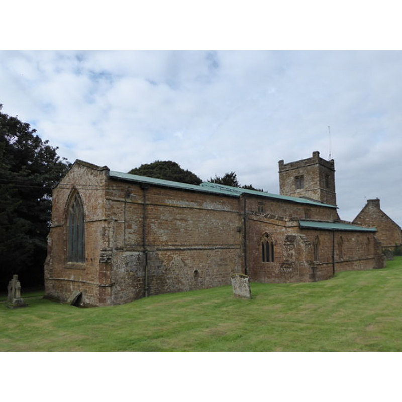
Copyright Statement: Image copyright © Basher Eyre, 2016
Image Source: digital photograph taken 31 August 2016 by Basher Eyre [www.geograph.org.uk/photo/5098705] [accessed 13 November 2017]
Copyright Instructions: CC-BY-SA-2.0
view of church exterior - northwest view
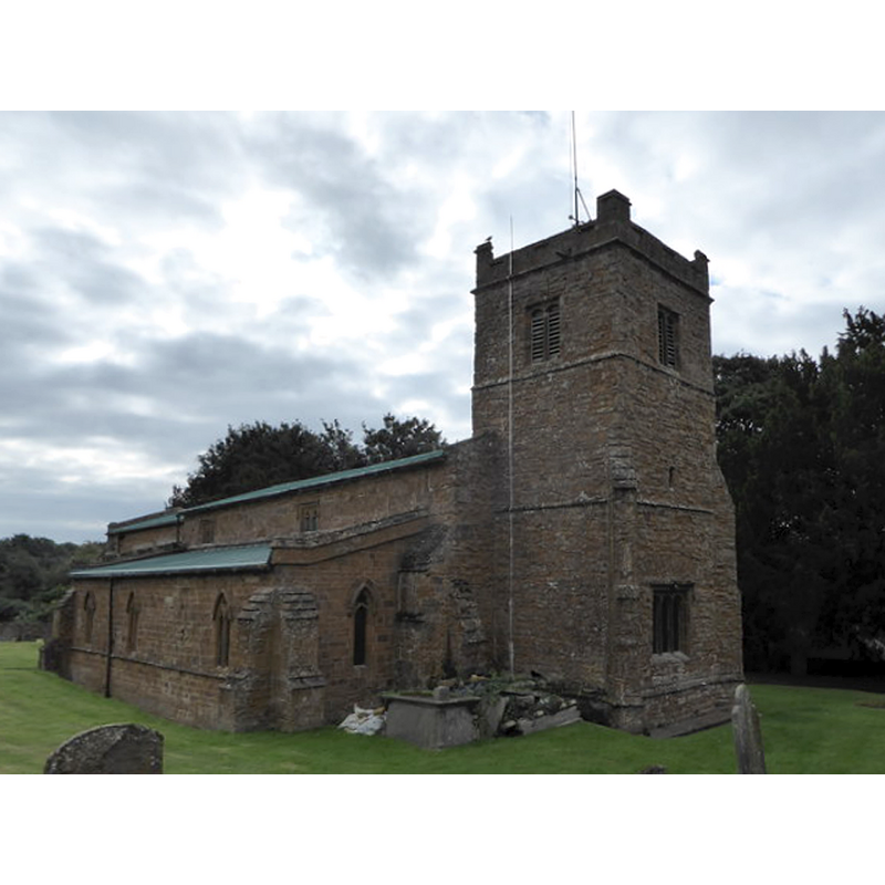
Copyright Statement: Image copyright © Basher Eyre, 2016
Image Source: digital photograph taken 31 August 2016 by Basher Eyre [www.geograph.org.uk/photo/5098702] [accessed 13 November 2017]
Copyright Instructions: CC-BY-SA-2.0
view of font and cover in context
Scene Description: the round stem and the polygonal lower base are modern, as is the font cover
Copyright Statement: Image copyright © Basher Eyre, 2016
Image Source: digital photograph taken 31 August 2016 by Basher Eyre [www.geograph.org.uk/photo/5098726] [accessed 13 November 2017]
Copyright Instructions: CC-BY-SA-2.0
INFORMATION
Font ID: 12714MOL
Object Type: Baptismal Font1
Font Century and Period/Style: 12th - 13th century [basin only], Transitional / Early English [altered]
Church / Chapel Name: Parish Church of All Saints
Font Location in Church: Inside the church
Church Patron Saint(s): All Saints
Church Address: Church Lane, Mollington, Oxfordshire, OX17 1BB, UK
Site Location: Oxfordshire, South East, England, United Kingdom
Directions to Site: Located off (E) the A423, 7 km NNW of Banbury
Ecclesiastic Region: Diocese of Oxford
Historical Region: Hundred of Hunesberi
Additional Comments: altered font / composite font [cf. FontNotes]
Font Notes:
Click to view
There are three entries for Mollington [variant spelling] in the Domesday survey [http://opendomesday.org/place/SP4447/mollington/] [accessed 13 November 2017], none of which mentions priest or church in it. Lewis' Dictionary of 1848 notes: "the font is semi-Norman". [NB: by 'semi-Norman' Lewis may mean that it is part Norman, which probably refers to the basin having been re-set on a later base, or that it is actually Transitional, which it probably is]. The Ecclesiastical and Architectural Topography of England: Oxfordshire (1850) notes: "The font is Transition N[orman]". Kelly's Directory of 1911 describes it as "Transition Norman". The Victoria County History informs (Oxford, vol. 10, 1972): "the font, which is decorated with dog-tooth ornament of the 13th century". Noted in Sherwood & Pevsner (1974): "Early C13, with blank intersecting arches and a band of dogtooth." The font consists of a bucket-shaped basin decorated with saw-tooth at the upper rim; short plain cylindrical stem; moulded base, modern. Flat round wooden cover with Latin cross finial/handle, probably modern as well.
COORDINATES
UTM: 30U 612203 5776097
Latitude & Longitude (Decimal): 52.124, -1.361
Latitude & Longitude (DMS): 52° 7′ 26.4″ N, 1° 21′ 39.6″ W
MEDIUM AND MEASUREMENTS
Material: stone
Font Shape: bucket-shaped, mounted
Basin Interior Shape: round
Basin Exterior Shape: round
LID INFORMATION
Date: modern
Material: wood
Apparatus: no
Notes: [cf. FontNotes]
REFERENCES
- Victoria County History [online], University of London, 1993-. URL: https://www.british-history.ac.uk.
- Kelly, Kelly's Directory of Oxfordshire, London: Kelly's Directories Ltd., 1911, p. 153 / [http://www.historicaldirectories.org/hd/d.asp] [accessed 22 July 2007]
- Lewis, Samuel, A Topographical Dictionary of England, Comprising the Several Counties, Cities, Boroughs, Corporate and Market Towns, Parishes, Chapelries, and Townships, and the Islands of Guernsy, Jersey, and Man, with Historical and Statistical Descriptions [...], London: S. Lewis, 1831, [www.british-history.ac.uk/report.asp?compid=51155] [accessed 19 February 2007]
- Parker, John Henry, The Ecclesiastical and architectural topography of England: Oxfordshire, Oxford, London: Published under the sanction of the Central Commitee of the Archaeological Institute of Great Britain and Ireland [by] John Henry Parker, 1850, [unpaged -- entry 137] / [http://books.google.ca/books?id=maikb1i3wSUC&pg=PT144&lpg=PT144&dq=longcot+church+font&source=web&ots=p3k5tJJE6J&sig=KYjkm8H5wOoAuH7BvnLp7JqMPus&hl=en&sa=X&oi=book_result&resnum=6&ct=result#PPA17,M1] [accessed 31 December 2008]
- Pevsner, Nikolaus, Oxfordshire, Harmondsworth: Penguin Books, 1974, p. 711