Field Dalling / Dalinga / Dalliga / Dallinga
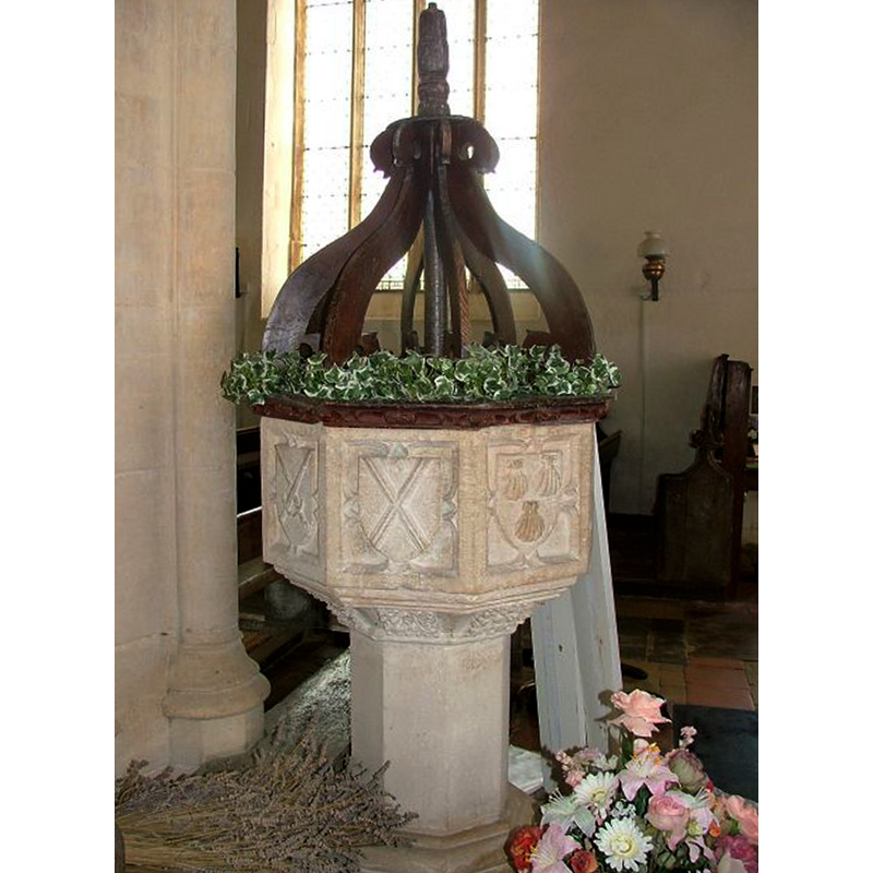
Image copyright © Simon Knott, 2004
Standing permission
Results: 10 records
view of font and cover
Copyright Statement: Image copyright © Simon Knott, 2004
Image Source: digital photograph November 2004 taken by Simon Knott [www.norfolkchurches.co.uk/fielddalling/fielddalling.htm] [accessed 11 December 2013]
Copyright Instructions: Standing permission
view of basin - detail
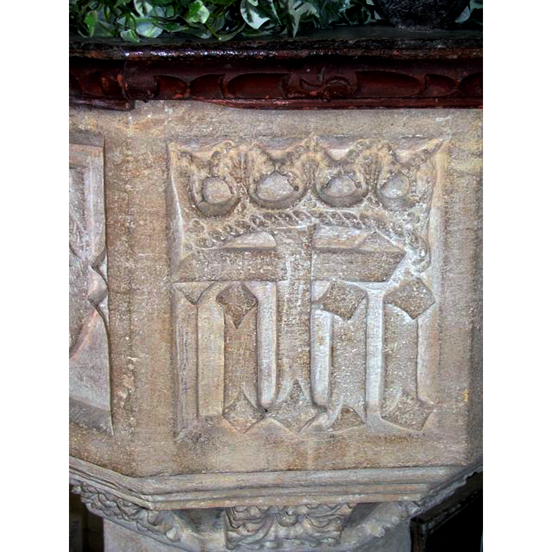
Scene Description: a re-carved emblem not inscribed in a shield
Copyright Statement: Image copyright © Simon Knott, 2004
Image Source: digital photograph November 2004 taken by Simon Knott [www.norfolkchurches.co.uk/fielddalling/fielddalling.htm] [accessed 11 December 2013]
Copyright Instructions: Standing permission
symbol - shield - coat of arms - 8
![most of them inscribed in shields; all modern re-cuts [cf. Font notes]](/static-50478a99ec6f36a15d6234548c59f63da52304e5/compressed/1131215038_compressed.png)
Scene Description: most of them inscribed in shields; all modern re-cuts [cf. Font notes]
Copyright Statement: Image copyright © Simon Knott, 2004
Image Source: digital photograph November 2004 taken by Simon Knott [www.norfolkchurches.co.uk/fielddalling/fielddalling.htm] [accessed 11 December 2013]
Copyright Instructions: Standing permission
view of basin
Scene Description: showing three of the re-cut panels and underbowl chamfer; notice also the detail work on the sides of the font cover platform
Copyright Statement: Image copyright © Simon Knott, 2004
Image Source: digital photograph November 2004 taken by Simon Knott [www.norfolkchurches.co.uk/fielddalling/fielddalling.htm] [accessed 11 December 2013]
Copyright Instructions: Standing permission
view of church exterior - southeast view
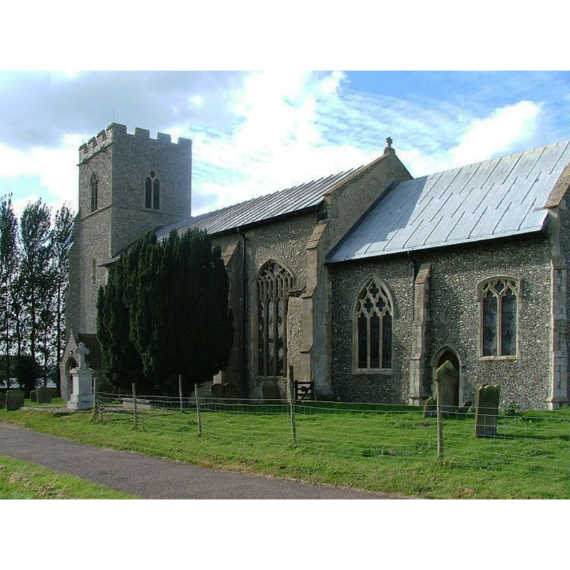
Copyright Statement: Image copyright © Simon Knott, 2004
Image Source: digital photograph November 2004 taken by Simon Knott [www.norfolkchurches.co.uk/fielddalling/fielddalling.htm] [accessed 11 December 2013]
Copyright Instructions: Standing permission
view of church exterior - south view
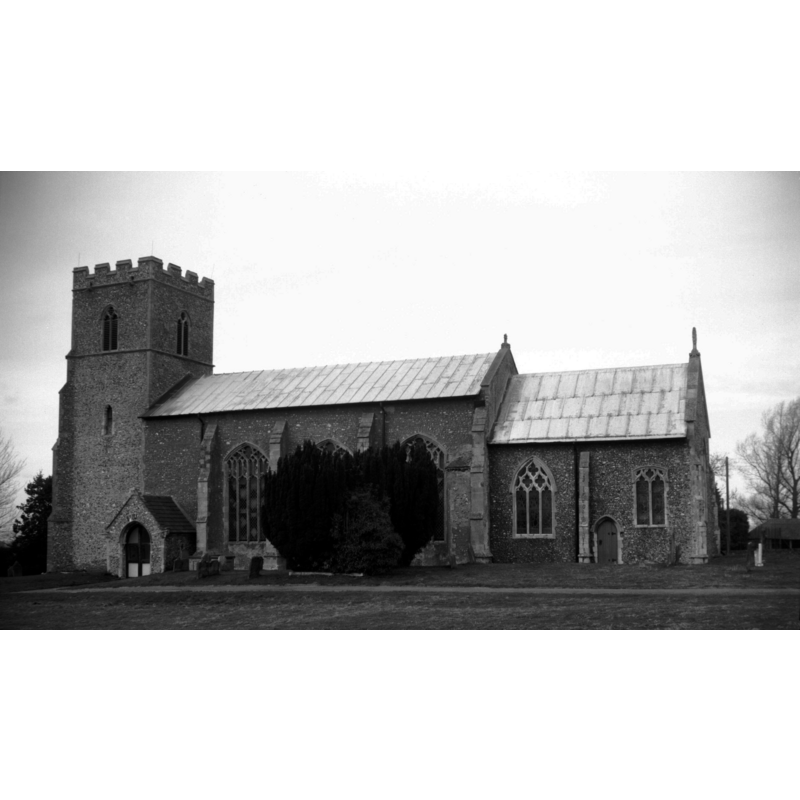
Scene Description: Photo caption: “Decorated west tower and chancel. Perpendicular nave. The tower is not in line with the nave"
Copyright Statement: Image copyright © George Plunkett, 2013
Image Source: B&W photograph taken 6 March 1994 by George Plunkett [www.georgeplunkett.co.uk/Norfolk/F/Field Dalling St Andrew's church south side [7111] 1994-03-06.jpg] [accessed 11 December 2013]
Copyright Instructions: Standing permission by Jonathan Plunkett
view of font and cover in context
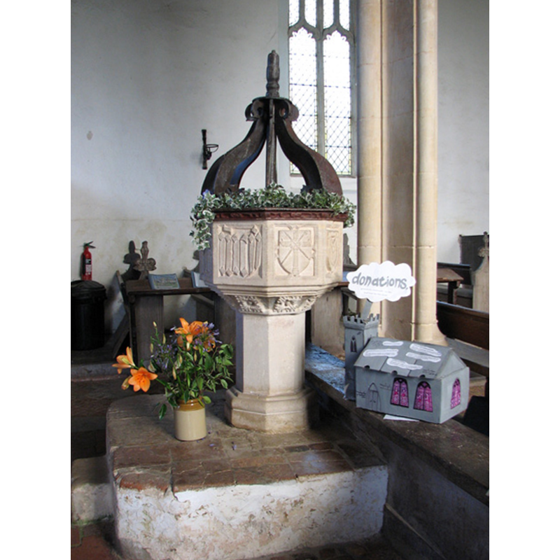
Scene Description: at the west end -- note the old encaustic tiles on the plinth
Copyright Statement: Image copyright © Evelyn Simak, 2010
Image Source: digital photograph taken 2 September 2010 by Evelyn Simak [www.geograph.org.uk/photo/2048497] [accessed 11 December 2013]
Copyright Instructions: CC-BY-SA-3.0
view of church interior - nave - looking west
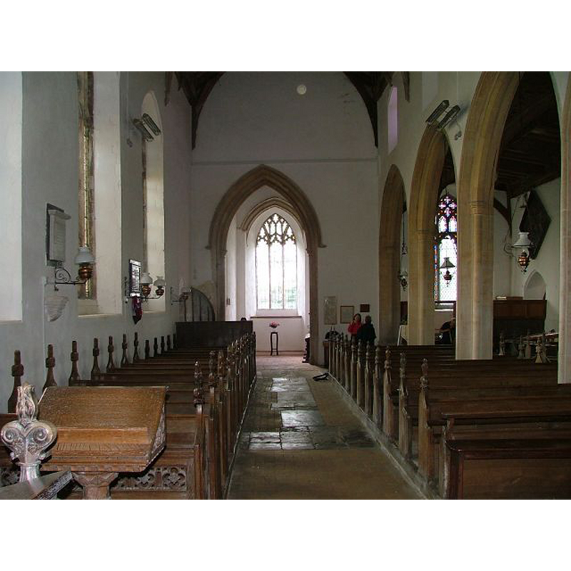
Copyright Statement: Image copyright © Simon Knott, 2004
Image Source: digital photograph November 2004 taken by Simon Knott [www.norfolkchurches.co.uk/fielddalling/fielddalling.htm] [accessed 11 December 2013]
Copyright Instructions: Standing permission
view of church interior - nave - looking east
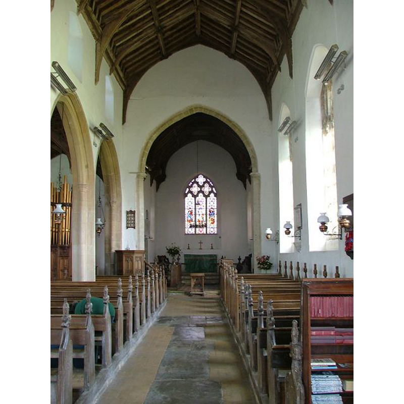
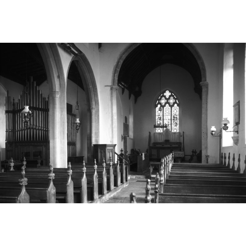
Copyright Statement: Image copyright © George Plunkett, 2013
Image Source: B&W photograph taken 6 March 1994 by George Plunkett [www.georgeplunkett.co.uk/Norfolk/F/Field Dalling St Andrew's church interior E [7112] 1994-03-06.jpg] [accessed 11 December 2013]
Copyright Instructions: Standing permission by Jonathan Plunkett
INFORMATION
Font ID: 12615FIE
Object Type: Baptismal Font1
Font Century and Period/Style: 15th century [re-cut], Perpendicular [altered?]
Church / Chapel Name: Parish Church of St. Andrew
Font Location in Church: Inside the church, at the W end
Church Patron Saint(s): St. Andrew
Church Address: Langham Road, Field Dalling, Norfolk NR25 7LG
Site Location: Norfolk, East Anglia, England, United Kingdom
Directions to Site: Located off Binham Road, 7 km WNW of Holt
Ecclesiastic Region: Diocese of Norwich
Historical Region: Hundred of North Greehow
Additional Comments: altered font (the present font appears to have been re-cut or restored) -- disappeared font (the one from the mid-12thC [cf. FontNotes]
Font Notes:
Click to view
There are four entries for Dalling [variant spellings] in the Domesday survey [http://domesdaymap.co.uk/place/TG0039/field-dalling/] [accessed 11 December 2013], Blomefield (1805-1810) metions the church here: "The Church is dedicated to St. Andrew, and is a vicarage [...] It was formerly a rectory [...] the priory of Castleacre: had a portion of tithe", and notes that "Richard de Saxlingham was rector about the reign of Henry II presented by Hardewine Bacun", and the rectors' list ends in 1384 with "Thomas in the Fen, [presented] by William in the Fen. In the fourth year of Richard II [i.e., 1381]. William Walsham, &c. aliened this rectory to the college of St. Mary in the fields, at Norwich, and Henry Bishop of Norwich appropriated it, on March 11, in the said year, [...] to the priory of Norwich, and a vicarage was settled", vicarage which starts in "1385, Roger Wychingham instituted vicar, presented by the dean, &c. of that college" [St. Mary in the Fields, Norwich]. It can therefore be assumed that the church here existed by the mid-12th century as a rectory. The present font here is reported in Lewis' Dictionary of 1848 simply as "a fine font". Farrer (1887 [1885?]) notes the emblems on the font: "II. Two swords in saltire, St Paul. -- III. A saltire, St, Andrew. -- IV. St. Andrew. -- V. Three escallops, St. James. -- VI. A cross surmounted of a crown of thorns, Shield of the Crucifixion. -- VII. The sacred monogram in Hebrew letters. -- VIII. A cross, with spear and reed in saltire. Shield of the Crucifixion. -- IX. Emblem of the Trinity." Described in Pevsner & Wilson (1997): "Font. Octagonal, Perp[endicular], drastically recut. Instruments of the Passion and emblem of the Trinity, St Andrew's Cross, crossed swords, monogram of Jesus, etc. Fleurons against the underside." Described and illustrated in Knott (2004). All the motifs mentioned above are on the basin and are actually re-cuts; the stem is a plain octagonal shaft, probably a replacement. The wooden font cover is of the Jacobean type consisting of an octagonal platform with eight raised scroll ribs around a centre pivot; probably 19th-century.
Credit and Acknowledgements: We are grateful to Simon Knott, of Norfolk Churches [www.norfolkchurches.co.uk], for his photographs of this church and font; we are also grateful to Jonathan Plunkett for the photographs of this church taken by his father, George Plunkett, in March 1994
COORDINATES
UTM: 31U 364352 5864282
Latitude & Longitude (Decimal): 52.911065, 0.982765
Latitude & Longitude (DMS): 52° 54′ 39.83″ N, 0° 58′ 57.95″ E
MEDIUM AND MEASUREMENTS
Material: stone
Font Shape: octagonal, mounted
Basin Interior Shape: round
Basin Exterior Shape: octagonal
LID INFORMATION
Date: 19th-century?
Material: wood
Apparatus: no
Notes: [cf. FontNotes]
REFERENCES
- Blomefield, Francis, An essay towards a topographical history of Norfolk, 1805-1810, vol. 9: 219-222 / [www.british-history.ac.uk/report.aspx?compid=78531] [accessed 11 December 2013]
- Knott, Simon, The Norfolk Churches Site, Simon Knott, 2004. [standing permission to reproduce images received from Simon (February 2005]. URL: www.norfolkchurches.co.uk.
- Lewis, Samuel, A Topographical Dictionary of England, Comprising the Several Counties, Cities, Boroughs, Corporate and Market Towns, Parishes, Chapelries, and Townships, and the Islands of Guernsy, Jersey, and Man, with Historical and Statistical Descriptions [...], London: S. Lewis, 1831, [www.british-history.ac.uk/report.asp?compid=50962] [accessed 5 February 2007]
- Pevsner, Nikolaus, Norfolk 1: Norwich and North-East [2nd ed.], Harmondsworth: Penguin Books, 1997, p. 468
- Torrens Alzu, Miguel A., "Baptisteria Sacra: índice iconográfico de pilas bautismales", 2 (Junio 2006), Románico: revista de arte de Amigos del Románico, 2006, pp. 24-27; vol. 2: 346