Donington nr. Spalding / Donninctune / Donintune / Duninctune
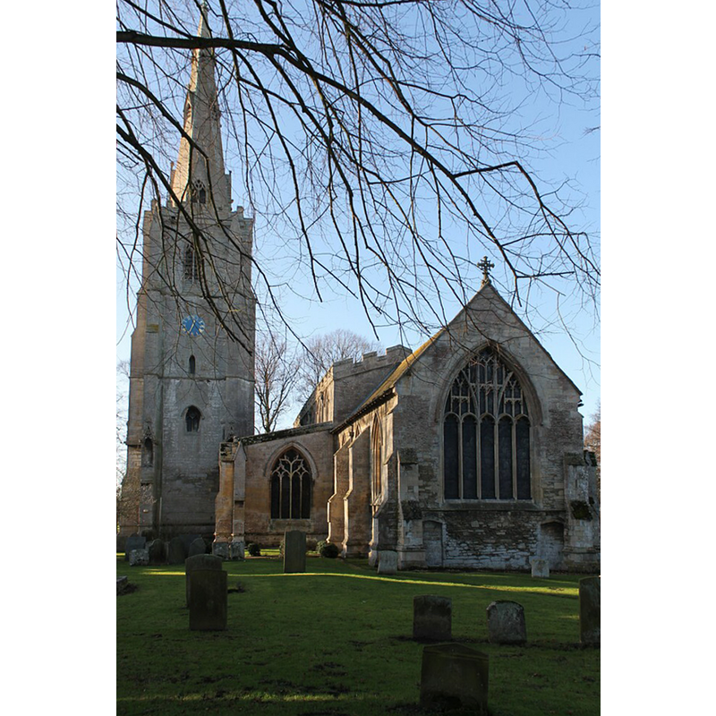
Image copyright © J. Hannan-Briggs, 2012
CC-BY-SA-2.0
Results: 3 records
view of church exterior - east view
Scene Description: Source caption: "St Mary & The Holy Rood church, Donington. The church is mainly late Decorated and Perpendicular (1300-1400) in style, but traces of Norman (1100) and Early English (1200) masonry can be found in its walls."
Copyright Statement: Image copyright © J. Hannan-Briggs, 2012
Image Source: digital photograph taken 2 January 2012 by J.Hannan-Briggs [www.geograph.org.uk/photo/2763456] [accessed 31 October 2018]
Copyright Instructions: CC-BY-SA-2.0
view of church interior - chancel
![Source caption: "Chancel, St Mary & Holy Rood church, Donington. [...] The Chancel walls, built of irregular rubble masonry, incorporate some of the oldest parts of the building. The oldest known part of the church is the east wall where two doorways, one each side of Holy Table and now walled up, seem to indicate that a chapel for relics once existed. The large 15th century window above the altar was enriched with stained glass in 1884 and shows the Ascension of Christ. Below the window and behind the altar is a beautiful Victorian-Gothic reredos which shows the four Evangelists in a marble mosaic. On the north wall, near its eastern end, masonry in the form of steps, suggests that there was once a room above the relic room before the large east window was erected in the 15th century."](/static-50478a99ec6f36a15d6234548c59f63da52304e5/compressed/1181031002_compressed.png)
Scene Description: Source caption: "Chancel, St Mary & Holy Rood church, Donington. [...] The Chancel walls, built of irregular rubble masonry, incorporate some of the oldest parts of the building. The oldest known part of the church is the east wall where two doorways, one each side of Holy Table and now walled up, seem to indicate that a chapel for relics once existed. The large 15th century window above the altar was enriched with stained glass in 1884 and shows the Ascension of Christ. Below the window and behind the altar is a beautiful Victorian-Gothic reredos which shows the four Evangelists in a marble mosaic. On the north wall, near its eastern end, masonry in the form of steps, suggests that there was once a room above the relic room before the large east window was erected in the 15th century."
Copyright Statement: Image copyright © J. Hannan-Briggs, 2012
Image Source: digital photograph taken 2 January 2012 by J.Hannan-Briggs [www.geograph.org.uk/photo/2763523] [accessed 31 October 2018]
Copyright Instructions: CC-BY-SA-2.0
design element - architectural - window
![[cf. Font notes]](/static-50478a99ec6f36a15d6234548c59f63da52304e5/others/image_not_available.jpg)
Scene Description: [cf. Font notes]
![[cf. Font notes]](/static-50478a99ec6f36a15d6234548c59f63da52304e5/bsi-testing-site/others/image_not_available.jpg)
INFORMATION
Font ID: 12597DON
Object Type: Baptismal Font1, fragment?
Font Century and Period/Style: 13th century, Early English
Church / Chapel Name: Parish Church of St. Mary and the Holy Rood
Font Location in Church: Inside the church, near the later font
Church Patron Saint(s): St. Mary the Virgin & Holy Cross
Church Address: Church St, Donington, Spalding PE11 4UA, UK
Site Location: Lincolnshire, East Midlands, England, United Kingdom
Directions to Site: Located off (S) the A52, 4 km NNW of Quadring, about 14 km NNW of Spalding
Ecclesiastic Region: Diocese of Lincoln
Historical Region: Hundred of Kirton
Additional Comments: disused font (the original 13thC font) / the present font in use is Victorian
Font Notes:
Click to view
There are three entries for this Donington [variant spellings] in the Domesday survey [https://opendomesday.org/place/TF2035/donington/] [accessed 29 October 2018], none of which mentions cleric or church in it. Pevsner, Harris and Antram (1989) mention a second font after the description of the Victorian font in use ["octagonal, stem and bowl in one, Dec window patterns under crocketted gables"]: "The upper part of the original font nearby. This also had blank window patterns". The entry for this church in Historic England [Listing NGR: TF2082035941] notes: "Parish church. C13, C14, C15, restored in 1868 and 1896. [...] Tall late C14 octagonal font with traceried and crocketed panels."
COORDINATES
UTM: 30U 688022 5865630
Latitude & Longitude (Decimal): 52.9074, -0.204
Latitude & Longitude (DMS): 52° 54′ 26.64″ N, 0° 12′ 14.4″ W
MEDIUM AND MEASUREMENTS
Material: stone
REFERENCES
- Pevsner, Nikolaus, Lincolnshire, London: Penguin, 1989, p. 256