Asterby / Estrebi
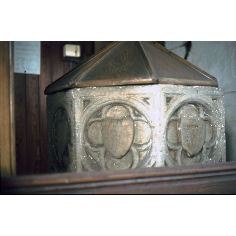
Image copyright © Society for Lincolnshire History and Archaeology, 2019
CC-BY-SA-2.0
Results: 4 records
view of basin and cover
Scene Description: Source caption: "The medieval font at the rear of the church. Valerie Hinkins, c.1980"
Copyright Statement: Image copyright © Society for Lincolnshire History and Archaeology, 2019
Image Source: digital image of a photograph taken ca. 1980 by Valery Hinkins, in the Society for Lincolnshire History and Archaeology [http://www.slha.org.uk/photogallery/?thistopic=Churches_InteriorFonts] [accessed 28 January 2019]
Copyright Instructions: CC-BY-SA-2.0
symbol - shield - blank - in a quatrefoil - in a circle - in a square - 8
Copyright Statement: Image copyright © Society for Lincolnshire History and Archaeology, 2019
Image Source: digital image of a photograph taken ca. 1980 by Valery Hinkins, in the Society for Lincolnshire History and Archaeology [http://www.slha.org.uk/photogallery/?thistopic=Churches_InteriorFonts] [accessed 28 January 2019]
Copyright Instructions: CC-BY-SA-2.0
view of church exterior - west view
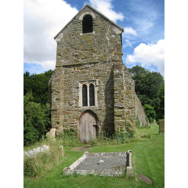
Scene Description: Source caption: "St. Peter's, Asterby, west tower. St. Peter's is marked on OS maps as not having a tower but it clearly does have one, albeit not very high. The upper part dates from 1900 the lower part from the late fifteenth century."
Copyright Statement: Image copyright © Jonathan Thacker, 2012
Image Source: digital photograph taken 18 August 2012 by Jonathan Thacker [www.geograph.org.uk/photo/3091114] [accessed 28 January 2019]
Copyright Instructions: CC-BY-SA-2.0
view of church exterior - southwest view
![Source caption: "St Peter's church, Asterby. [...] The church dates from the mid-14th century onwards. It is built from green sandstone, limestone and redbrick. The church consists of a western tower, nave, chancel and a north aisle which is truncated. The west tower is late 15th century it was altered in the early 19th century. The north aisle was originally four bays, the two western bays were removed and patched with brick in the early 19th century. The piers are octagonal. The chancel arch is 14th century, most of the other fittings are 19th century. The village of Asterby was once a thriving village, but now there is very little left. The church was declared redundant in 1983 and is now privately owned."](/static-50478a99ec6f36a15d6234548c59f63da52304e5/compressed/1190128022_compressed.png)
Scene Description: Source caption: "St Peter's church, Asterby. [...] The church dates from the mid-14th century onwards. It is built from green sandstone, limestone and redbrick. The church consists of a western tower, nave, chancel and a north aisle which is truncated. The west tower is late 15th century it was altered in the early 19th century. The north aisle was originally four bays, the two western bays were removed and patched with brick in the early 19th century. The piers are octagonal. The chancel arch is 14th century, most of the other fittings are 19th century. The village of Asterby was once a thriving village, but now there is very little left. The church was declared redundant in 1983 and is now privately owned."
Copyright Statement: Image copyright © J. Hannan-Briggs, 2012
Image Source: digital photograph taken 9 December 2012 by J. Hannan-Briggs [www.geograph.org.uk/photo/3254942] [accessed 28 January 2019]
Copyright Instructions: CC-BY-SA-2.0
INFORMATION
Font ID: 12521AST
Object Type: Baptismal Font1
Font Century and Period/Style: 15th century, Perpendicular
Workshop/Group/Artisan: heraldic font
Church / Chapel Name: Parish Church of St. Peter [redundant 1983; deconsecrated; now a private residence]
Font Location in Church: [cf. FontNotes]
Church Patron Saint(s): St. Peter
Church Address: Asterby Ln, Asterby, Louth LN11 9UF, UK
Site Location: Lincolnshire, East Midlands, England, United Kingdom
Directions to Site: Located between Goulceby and Scamblesby, 12 km N of Horncastle, W of Louth
Ecclesiastic Region: [Diocese of Lincoln]
Historical Region: Hundred of Gartree
Additional Comments: disappeared font? (the one from the mid-14thC church here)
Font Notes:
Click to view
There is an entry for Asterby [variant spelling] in the Domesday survey [https://opendomesday.org/place/TF2679/asterby/] [accessed 28 January 2019] but it mentions neither cleric nor church in it. The entry for this church in Allen's The history of the county of Lincoln (London: John Saunders, 1834), vol. 2, p. 86, gives a rather disdainful note: "The ehurch dedicated to St. Peter is a small structure, containing nothing of interest". Pevsner, Harris and Antram (1989) note: "Font. Octagonal, Perp[endicular]." The entry for this church in Historic England [Listing NGR: TF2639079514] notes: "Parish church, now redundant. Mid C14, late C15, early C19, late C19"; no font mentioned in it. [NB: there is a photograph of the font "at the rear of the church" dated ca. 1980, but we have no information on the whereabouts of the font after the deconsecration and sale of the church].
Credit and Acknowledgements: We are grateful to Ken Redmore, Website Editor, the Society for Lincolnshire History and Archaeology, for the photograph of this font
COORDINATES
UTM: 30U 692855 5909306
Latitude & Longitude (Decimal): 53.2978, -0.106
Latitude & Longitude (DMS): 53° 17′ 52.08″ N, 0° 6′ 21.6″ W
MEDIUM AND MEASUREMENTS
Material: stone
Font Shape: octagonal, mounted
Basin Interior Shape: round
Basin Exterior Shape: octagonal
LID INFORMATION
Date: modern?
Material: wood, oak?
Apparatus: no
Notes: low pyramidal octagon with raised arrises; appears modern
REFERENCES
- Pevsner, Nikolaus, Lincolnshire, London: Penguin, 1989, p. 108