Allington / Adelinctune / Adelingetone / West Allington
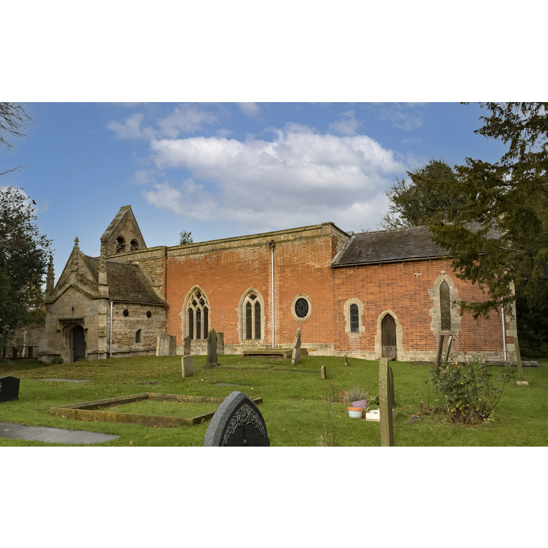
Image copyright © Julian P Guffogg, 2021
CC-BY-SA-2.5
Results: 5 records
view of church exterior - northeast view
Scene Description: Source caption: "Holy Trinity church, Allington. From the south east."
Copyright Statement: Image copyright © Julian P Guffogg, 2021
Image Source: digital photograph 3 December 2021 by Julian P Guffogg [https://www.geograph.org.uk/photo/7034927] [accessed 19 November 2023]
Copyright Instructions: CC-BY-SA-2.5
design element - motifs - floral
![[cf. Font notes]](/static-50478a99ec6f36a15d6234548c59f63da52304e5/others/image_not_available.jpg)
Scene Description: [cf. Font notes]
![[cf. Font notes]](/static-50478a99ec6f36a15d6234548c59f63da52304e5/bsi-testing-site/others/image_not_available.jpg)
human figure - head
Scene Description: [cf. Font notes]
symbol - shield
Scene Description: [cf. Font notes]
design element - motifs - foliage
Scene Description: [cf. Font notes]
INFORMATION
Font ID: 12516ALL
Object Type: Baptismal Font1
Font Century and Period/Style: 15th century (late?), Perpendicular
Workshop/Group/Artisan: heraldic font
Church / Chapel Name: Parish Church of the Holy Trinity
Font Location in Church: Inside the church
Church Patron Saint(s): The Holy Trinity
Church Address: Allington, Grantham NG32 2EB, United Kingdom -- Tel.: +44 1400 281524
Site Location: Lincolnshire, East Midlands, England, United Kingdom
Directions to Site: Located off (S) the A1, 9 km NW of Grantham
Ecclesiastic Region: Diocese of Lincoln
Historical Region: hundred of Winnibriggs [in Domesday]
Additional Comments: disappeared font? (the one from the ca.1150 church here; the Domesday survey reports two churches here)
Font Notes:
Click to view
There are three entries for [East and West] Allington [variant spellings] in the Domesday survey [https://opendomesday.org/place/XX0000/east-and-west-allington/] [accessed 19 November 2023]; the one in the lordship of Robert of Tosny reports a church in it, and the one in the lordship of Beregar of Tosny reports a church and 0.5 church lands in it. Noted in Pevsner, Harris and Antram (1989): "Font. Octagonal, Perp[endicular]. Stem with leaf motifs. On the bowl, lozenge-shaped fields with flowers, heads, and a shield." The entry for this church in Historic England [Listing NGR: SK8552840262] notes: "Parish Church, c.1150, C13, C15, C16, late C18, c.1914 [...] Late C15 octagonal font with panels containing heads, flowers and a shield on an octagonal support with deeply cut foliage in small panels. 2 fragments near font, one of C12 chevron, the other of C11 plaited cable."
COORDINATES
UTM: 30U 652630 5869436
Latitude & Longitude (Decimal): 52.9528, -0.728
Latitude & Longitude (DMS): 52° 57′ 10.08″ N, 0° 43′ 40.8″ W
MEDIUM AND MEASUREMENTS
Material: stone
Font Shape: octagonal, mounted
Basin Interior Shape: round
Basin Exterior Shape: octagonal
REFERENCES
- Pevsner, Nikolaus, Lincolnshire, London: Penguin, 1989, p. 97