Whitwell nr. Oakham / Whightwell / Whitewell / Whithewelle / Whytewell / Whitwell / Witewelle / Wittwell / Wytewell
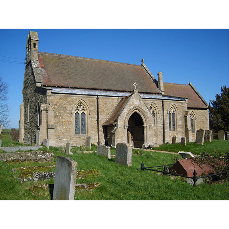
Image copyright © Carl Baker, 2007
CC-BY-SA-2.0
Results: 4 records
view of church exterior - southwest view
Copyright Statement: Image copyright © Carl Baker, 2007
Image Source: digital photograph taken 5 Match 2007 by Carl Baker [www.geograph.org.uk/photo/376117] [accessed 20 July 2015]
Copyright Instructions: CC-BY-SA-2.0
design element - motifs - foliage
![on two [original?] side [cf. Font notes]](/static-50478a99ec6f36a15d6234548c59f63da52304e5/others/image_not_available.jpg)
Scene Description: on two [original?] side [cf. Font notes]
![on two [original?] side [cf. Font notes]](/static-50478a99ec6f36a15d6234548c59f63da52304e5/bsi-testing-site/others/image_not_available.jpg)
symbol - cross
Scene Description: on two [original?] side [cf. Font notes]
design element - architectural - arch
Scene Description: on two [original?] side [cf. Font notes]
INFORMATION
Font ID: 12512WHI
Object Type: Baptismal Font1
Font Century and Period/Style: 11th - 12th century [basin only] [altered?], Medieval / composite
Church / Chapel Name: Parish Church of St. Michael and All Angels
Font Location in Church: Inside the church, behind (W) the westernmost pillar of the arcade separating the nave from the S aisle
Church Patron Saint(s): St. Michael & All Angels
Church Address: Bull Brigg Lane, Whitwell, Rutland, LE15 8BL, UK
Site Location: Rutland, East Midlands, England, United Kingdom
Directions to Site: Located off (S) the A606, 6 km E of Oakham
Ecclesiastic Region: Diocese of Peterborough
Historical Region: Hundred of Alstoe
Additional Comments: altered font? re-cut? (is this the 11th-12thC font re-cut in the 14thC?)
Font Notes:
Click to view
There are two entries for this Whitwell [variant spelling] in the Domesday survey [http://opendomesday.org/place/SK9208/whitwell/] [accessed 20 July 2015], each of which mentions a priest and a church in it. The Victoria County History (Rutland, vol. 2, 1935) notes: "The bowl of the late 12th-century font was originally square, the sides ornamented with rudely incised patterns (crosses, arches, etc.), but the angles have been cut away, reducing the bowl to an irregular octagon. It stands on a modern circular stem and base and has a flat 17th-century cover"; the VCH shows the location of the font behind (west of) the westernmost pillar of the arcade that separates the nave from the south aisle. Noted in Pevsner (1984): "Font. Formerly square and seemingly re-cut. Two faces appear to have been carved free-hand, but the others were apparently laid out with instruments. The original faces with a foliage pattern, perhaps late Saxon (D. Parsons)". The entry in English Heritage [Listing NGR: SK9236508804] (1954) reads: "Font, octagonal with incised decoration, C14.?
COORDINATES
UTM: 30U 659895 5838064
Latitude & Longitude (Decimal): 52.6689, -0.6353
Latitude & Longitude (DMS): 52° 40′ 8.04″ N, 0° 38′ 7.08″ W
MEDIUM AND MEASUREMENTS
Material: stone
Font Shape: square [re-cut?]
Basin Exterior Shape: square [re-cut?]
REFERENCES
- Victoria County History [online], University of London, 1993-. URL: https://www.british-history.ac.uk.
- Pevsner, Nikolaus, Leicestershire and Rutland, Harmondsworth: Penguin Books, 1984, p. 522