Whiston nr. Northampton / Wicentone / Wicetone
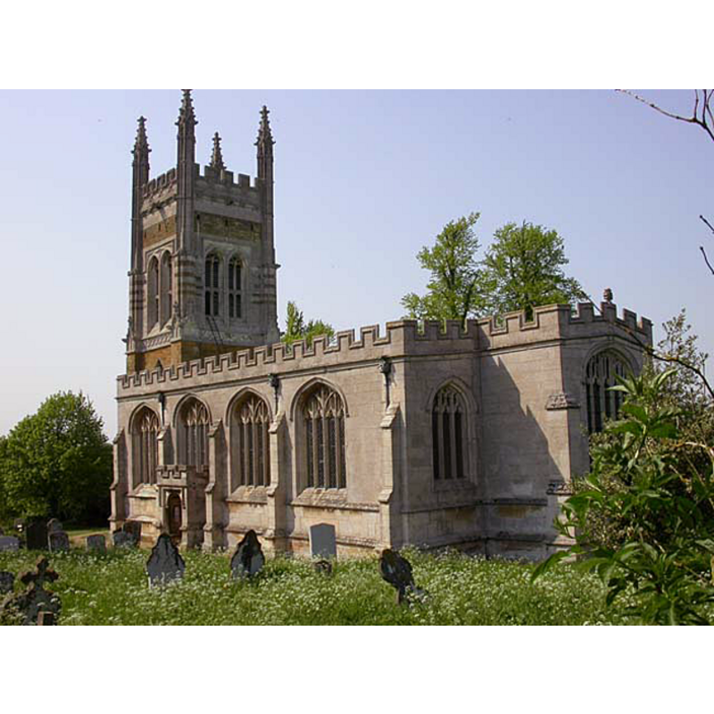
Image copyright © Kokai, 2006
CC-BY-SA-3.0
Results: 3 records
B01: symbol - shield - in a quatrefoil
![[cf. Font notes]](/static-50478a99ec6f36a15d6234548c59f63da52304e5/others/image_not_available.jpg)
Scene Description: [cf. Font notes]
![[cf. Font notes]](/static-50478a99ec6f36a15d6234548c59f63da52304e5/bsi-testing-site/others/image_not_available.jpg)
UB01: design element - motifs - panel
Scene Description: [cf. Font notes]
view of church exterior - southeast view
Copyright Statement: Image copyright © Kokai, 2006
Image Source: digital photograph taken 11 May 2006 Kokai [www.geograph.org.uk/photo/169404] [accessed 5 June 2012]
Copyright Instructions: CC-BY-SA-3.0
INFORMATION
Font ID: 12511WHI
Object Type: Baptismal Font1
Font Date: ca. 1534?
Font Century and Period/Style: 16th century(early?), Perpendicular
Workshop/Group/Artisan: heraldic font
Church / Chapel Name: Parish Church of St. Mary the Virgin
Font Location in Church: Inside the church, in the W end of the nave
Church Patron Saint(s): St. Mary the Virgin
Church Address: Whiston, Northamptonshire, NN7 1NP, UK
Site Location: Northamptonshire, East Midlands, England, United Kingdom
Directions to Site: Located 7 km ESE of Northampton
Ecclesiastic Region: Diocese of Peterborough
Historical Region: Hundred of Wymersley [in Domesday]
Font Notes:
Click to view
Noted in Lewis' Dictionary of 1848: "The font is octagonal, with panelled sides handsomely executed". In Rickman (1861): "The font, of the date of the church and of good composition, octagon, with panelled sides". Described in the Victoria County History (Northampton, vol. 4, 1937): "The font is contemporary with the church ["The church was built in 1534"], and consists of an octagonal panelled bowl and pedestal on two square steps. It has an interesting Jacobean oak cover with twisted balusters supporting a small canopy." The interior plan in the VCH shows the font located in the nave, by the inner side of the western-most pillar of the arcade that separates the nave from the south aisle. Described in Pevsner & Cherry (1973): "Font. Octagonal, Perp[endicular], with panelled stem and shields in quatrefoils on the bowl. Font canopy. Of oak, with five turned cork-screw posts supporting a pyramidal top, an unusual design. Probably mid-C17 (Alec Clifton-Taylor).""
COORDINATES
UTM: 30U 653381 5789677
Latitude & Longitude (Decimal): 52.23611, -0.753789
Latitude & Longitude (DMS): 52° 14′ 10″ N, 0° 45′ 13.64″ W
MEDIUM AND MEASUREMENTS
Material: stone
Font Shape: octagonal, mounted
Basin Interior Shape: round
Basin Exterior Shape: octagonal
LID INFORMATION
Date: 17th-century (mid?)
Material: wood, oak
Notes: [cf. FontNotes]
REFERENCES
- Victoria County History [online], University of London, 1993-. URL: https://www.british-history.ac.uk.
- Lewis, Samuel, A Topographical Dictionary of England, Comprising the Several Counties, Cities, Boroughs, Corporate and Market Towns, Parishes, Chapelries, and Townships, and the Islands of Guernsy, Jersey, and Man, with Historical and Statistical Descriptions [...], London: S. Lewis, 1831, [www.british-history.ac.uk/report.asp?compid=51397] [accessed 11 January 2007]
- Pevsner, Nikolaus, Northamptonshire, Harmondsworth: Penguin Books, 1973, p. 459-460
- Rickman, Thomas, An Attempt to Discriminate the Styles of Architecture in England, from the Conquest to the Reformation, with a Sketch of the Grecian and Roman Orders, An [7th ed. -- orig. published in 1817], Oxford and London: Parker and Co., 1881, p. 282